
More than 10 tornadoes rip through Texas as severe weather sweeps across central U.S.
Severe weather swept across the central United States on Thursday, April 24, 2025, spawning over 16 tornadoes in six states, with 10 reported in Texas alone. Large hail of over 11 cm (4.5 inches) was also reported in multiple areas as storms passed over the Central and Southern Plains.
Severe weather, including thunderstorms and tornadoes, brought widespread damage across much of the central United States on Thursday, April 25, spawning tornadoes in six states. Texas was the most affected, reporting at least 10 tornadoes, according to the Storm Prediction Center (SPC).
Two tornadoes were reported in Oklahoma, and one each in Colorado, Louisiana, Iowa, and Nebraska on April 25. The total number is expected to increase as additional reports are received through April 26.
Large hail measuring over 11.4 cm (4.5 inches) was reported in parts of Texas, including Matador, where a significant tornado touched down on the evening of April 25.
The tornado in Matador was reported by multiple observers on social media, with indications that it passed approximately 18 km (11 miles) west of Matador at around 19:25 local time (LT).
Tornadoes were also reported in Floyd, Crosby, Motley, Garza, and Roberts Counties in Texas. The National Weather Service (NWS) issued multiple tornado and flash flood warnings throughout the region.
The NWS office in Lubbock confirmed multiple tornado sightings throughout April 25 and reported that the severe weather threat had moved out of the state by 23:05 LT.
Silverton tornado just roped out @NWSLubbock #txwx pic.twitter.com/TiMpwqkIYL
— Andrew Justin (@andrewjustinWX) April 24, 2025
Big time wedge continues. 7:25pm @NWSLubbock pic.twitter.com/vF2FsZcGMm
— Chad Casey (@WxFanaticCC) April 25, 2025
The storms were triggered by a larger weather system, with a frontal boundary stretching from the Great Lakes to the Central Plains, and a dry line extending southward across western Texas, creating favorable conditions for strong supercells in the region.
The barrage of severe weather over the central U.S. isn’t over yet. After a brief period of relative calm over the weekend, a shortwave trough ejecting from the Central Rockies on Monday, April 28, will bring severe weather to the Midwest and possibly over parts of the Southern Plains.
Thunderstorms, large hail, and possible tornadoes are forecast for Iowa, Oklahoma, Texas, Kansas, and Wisconsin.
Iowa, along with parts of northeast Kansas, will be at the greatest risk of severe weather through Monday.
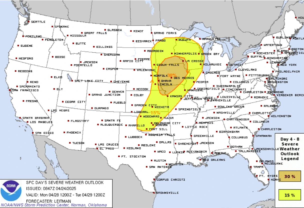
The Storm Prediction Center (SPC) has outlined an area of Enhanced Risk (30% chance) of severe weather over Iowa and parts of surrounding states for Monday. A larger area of Slight Risk (15 % chance) of severe weather, extending from the Great Lakes to the Southern Plains.
References:
1 SPC Storm Reports for April 24, 2025 – SPC – April 25, 2025
Feature image credit: Chad Casey

I am an Assistant Editor and Severe Weather & Science Journalist at The Watchers, specializing in real-time severe weather coverage, geophysical event reporting, and research-driven scientific analysis. You can reach me at rishav(at)watchers(.)news.
Does anyone ever wonder if this ay be a warning from Almighty God? Lots of extreme weather in Texas…