
Powerful storm to slam California with heavy rain, strong winds, and heavy snowfall, U.S.

Image credit: NOAA/GOES-West, RAMMB/CIRA, The Watchers
A strong storm will move ashore across California today accompanied by strong winds, heavy rain and heavy snow for the higher terrain. Flooding will be of great concern for Southern California into portions of Arizona through Wednesday, March 22, 2023. Several feet of snow is expected across central and southern California Mountains into the central Great Basin. Snow will impact the northern Plains into tonight.
- The storm center is expected to approach and possibly make landfall near San Francisco this evening, bringing potentially damaging wind gusts, especially as the system acquires some sub-tropical characteristics near the center under an anomalously cold upper low over the ocean. A strong pressure gradient is also anticipated, which could lead to maximum wind gusts near 120.7 km/h (75 mph) across southern California.
California and several other southwestern states are bracing for a major weather event as a strong storm makes its way ashore. This system is expected to bring heavy rain, strong winds, and heavy snowfall to higher elevations. The storm will slam onshore across California, the Great Basin, Four Corners, and through the central and southern Rockies through Thursday morning.
According to NWS, this storm is being caused by a low-pressure system developing rapidly over the Pacific, which will deliver a powerful weather event over the southwestern quadrant of the country over the next couple of days. The outer edge of the precipitation associated with this system is already moving onshore across southern California.
As the storm system moves across the region, potentially damaging wind gusts may accompany the system, especially as the storm center approaches or makes landfall near San Francisco this evening. Farther south, maximum wind gusts could reach up to 120 km/h (75 mph) across southern California.
Moreover, the storm is also expected to bring heavy rain to central coastline and southern California, leading to rapid runoff and areas of flooding. In the mountainous regions of central and southern California, heavy snowfall is anticipated with accumulations of up to 91 to 122 cm (3 to 4 feet) in some spots. This could lead to difficult travel conditions and strain infrastructure in areas still recovering from a record-breaking snowpack.
The second half of Tuesday is expected to bring heavy snow to elevated terrain from central Nevada to western Colorado. Dangerous travel conditions are likely with most mountain ranges experiencing over 30 cm (1 foot) of snowfall.
Numerous wind, flood, and winter warnings have been issued for the upcoming storm. Residents are advised to check with their local forecast office for more information and to take necessary precautions.
The storm is anticipated to bring heavy flooding and snowfall to the southwestern region, so it is imperative to remain safe during this impactful weather event.
California is currently experiencing a winter season like no other, as snowpack statewide has exceeded double the normal levels for this time of year.
While the excess moisture is a much-welcomed relief for the state’s drought, the back-to-back winter storms have caused flooding around rivers and creeks, particularly in Porterville and Kernville in central California.
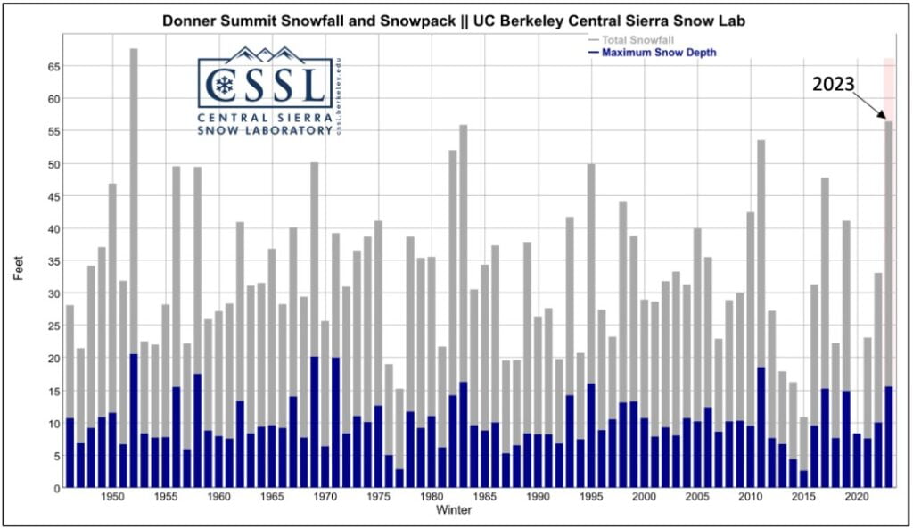
Despite the overwhelming moisture, the southern Sierra has experienced the most significant benefits of the active winter season. This season, Soda Springs, California has received 17.2 m (56.4 feet) of snow, marking the second snowiest season since records began in 1946.
References:
1 Short Range Forecast Discussion – NWS Weather Prediction Center College Park MD – 420 AM EDT Tue Mar 21 2023
2 From drought to deluge: California experiences second snowiest winter on record – The Watchers – March 21, 2023

Teo Blašković founded The Watchers in 2011 and edited it until 2026, covering seismic and volcanic activity, extreme weather, space weather and near-Earth objects. Articles on this page are his archive.
Published in the last 24 hours
- 2 atmospheric rivers to bring heavy Sierra snow and California flood risk
- The storms drenching California this week are fed by a river in the sky, a band of water vapor that can carry up to 15 times the flow of the Mississippi River, and this winter’s near-record El Niño could keep aiming more of them at the West Coast
- Atmospheric river brings moderate risk of heavy rain, mountain snow and high winds to northern California and southwest Oregon on November 24-25
- 190 mm of rain and 131 km/h gusts hit New Zealand's South Island, flooding West Coast highways
