
From drought to deluge: California experiences second snowiest winter on record
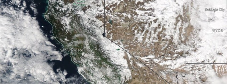
Image credit: NASA Aqua/MODIS. Acquired on March 20, 2023
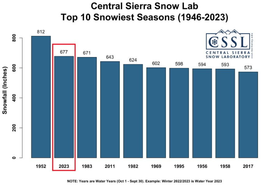
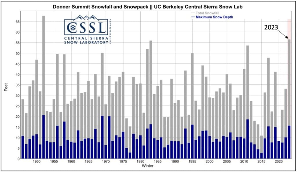
This winter season in California has been one for the books, with snowpack statewide doubling the normal levels and much above what’s typical by April 1st, historically the deepest snow depth of the season. Despite widespread flooding and mandatory evacuations around rivers and creeks, the southern Sierra region, particularly Soda Springs, has seen an impressive amount of snowfall, marking the second snowiest winter on record with over 17 m (56 feet) of snow. While still shy of the record set during the 1951-52 season, with more snow predicted, it’s expected to come close in the next couple of weeks.
California is currently experiencing a winter season like no other, as snowpack statewide has exceeded double the normal levels for this time of year. While the excess moisture is a much-welcomed relief for the state’s drought, the back-to-back winter storms have caused flooding around rivers and creeks, particularly in Porterville and Kernville in central California.
Despite the overwhelming moisture, the southern Sierra has experienced the most significant benefits of the active winter season. This season, Soda Springs, California has received 17.2 m (56.4 feet) of snow, marking the second snowiest season since records began in 1946.
Although the area is about 3.35 m (11 feet) shy of the record set during the 1951-52 season, with more snow predicted in the next couple of weeks, it’s expected to come very close to or even exceed that record.
Another area of low pressure in California’s upper atmosphere is expected to team up with Pacific moisture to continue to bring heavy snowfall and gusty winds to the southwest through mid-week.
A significant weather event is forecast to hit California and the southwestern quadrant of the United States over the next few days as a low-pressure system rapidly develops over the Pacific. The outer edge of the precipitation associated with this system is already moving onshore across southern California. The National Weather Service predicts heavy rain and mountain snow to expand through California, the Great Basin, the Four Corners, and the central and southern Rockies as the system moves across these areas through Thursday morning.
The storm center is expected to approach and possibly make landfall near San Francisco this evening, bringing potentially damaging wind gusts, especially as the system acquires some sub-tropical characteristics near the center under an anomalously cold upper low over the ocean. A strong pressure gradient is also anticipated, which could lead to maximum wind gusts near 120.7 km/h (75 mph) across southern California.
The surge of subtropical moisture accompanying the system will create a ripe environment for heavy rain from the central coastline to southern California. Heavy rain is likely to lead to rapid runoff and areas of flooding across southern California, with isolated flooding instances possible for regions to the north. The mountainous terrain of the southern/central Sierra Nevada and Southern California will see heavy snow as snowfall accumulations add up to as much as 91.4 cm (3 to 4 feet) in spots. This additional snowfall will lead to difficult travel and could strain infrastructure in areas still buried under a record-breaking snowpack for the year-to-date.
The impacts of the storm are expected to spread farther inland during the second half of Tuesday across the Southwest, central Great Basin, and south/central Rockies. Gusty southwesterly winds up to 96.6 km/h (60 mph) are possible across the Desert Southwest, with heavy rain and localized flash flooding possible across parts of central Arizona. Elevated terrain from central Nevada to western Colorado can expect heavy snow to last into Wednesday, with most mountain ranges experiencing over a foot of snowfall.
Winter alerts are in place for the Sierra Nevada and San Gabriel mountains through Wednesday for heavy snow and gusty winds. Northern California has also been issued winter storm warnings, watches, and advisories, especially in the Sierra Nevada region, where snowfall totals are expected to be quite significant.
References:
1 California Snowfall: Now the Second Snowiest Winter ever on Record – Weather Nation – March 21, 2023
2 Short Range Forecast Discussion – NWS Weather Prediction Center College Park MD – 420 AM EDT Tue Mar 21 2023
The Watchers team and our contributors bring the latest on extreme weather, earthquakes, volcanic eruptions, space weather, and all things science. We're all about making sense of the natural world and keeping you informed on what’s happening. Got a tip or a question? Hit us up using the form at newstips!
Commenting rules and guidelines
We value the thoughts and opinions of our readers and welcome healthy discussions on our website. In order to maintain a respectful and positive community, we ask that all commenters follow these rules.