
Powerful storm continues across Northern U.S., Ice Storm Warnings issued
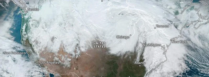
Image credit: NOAA/GOES-East, Zoom Earth, The Watchers. Acquired at 19:10 UTC on December 15, 2022
The powerful and massive multi-day storm continues across the Northern U.S. and in Florida on Thursday, December 15, 2022. Heavy snow, gusty winds and blizzard conditions continue across the Upper Midwest, while frozen precipitation of ice and snow begins in the central Appalachians and interior portions of the Northeast.
Heavy snow and blizzard conditions persist this morning across the Northern Tier of the central U.S. beneath a deep upper-level low as a plume of warmer, moist air flows over colder temperatures around a low at the surface, NWS forecaster Putnam noted.1
This low is forecast to slowly move to the northeast across the Upper Midwest through Saturday, December 17.
Snow will begin to taper off first over the Northern High Plains with little additional accumulations expected outside of the vicinity of the Black Hills.
Snow is forecast to continue into the day Thursday farther east in the Northern Plains and Upper Midwest.
Additional accumulations should be generally between 100 and 200 mm (4 – 8 inches), with higher amounts of 200 – 300+ mm (8 – 12+ inches) possible in the Red River Valley and in the Arrowhead of Minnesota.
Strong, gusty winds upwards of 80 km/h (50 mph) will lead to blizzard conditions for the Arrowhead of Minnesota while blowing snow will remain a concern over the High Plains even after the snow has concluded.
Snow should begin to taper off for the Upper Midwest as well late Thursday night into Friday. There will be a wintry mix further east over Michigan and the Lower Great Lakes with some light snow and ice accumulations possible through Thursday evening.
Snow will linger longer and higher accumulations are expected along the eastern shores of Lake Michigan and Lake Erie as flow turns easterly over the lakes and lake-effect snow ramps up late Friday, December 16 and continuing into Saturday, December 17.
Rain, a wintry mix, and snow have begun to overspread the Mid-Atlantic and Carolinas ahead of the frontal system to the west, Putnam said.
Heavy rain near the coast, significant freezing rain in the central/northern Appalachians, and heavy snow for the northern Appalachians and northern Mid-Atlantic are expected through Thursday as another low pressure center forms near the coast of the Carolinas and moves up the Eastern Seaboard.
Ice Storm Warnings are in effect for far northwestern Virginia, northeastern West Virginia, the far western Maryland Panhandle, and into south-central Pennsylvania.
Accumulations of 2.5 – 6 mm (0.1 – 0.25 inches) at lower elevations and 6 – 12 mm (0.25 to 0.5 inches) at higher elevations generally over 300 m (1 000 feet) are expected through the day Thursday.
Heavy snow totals between 150 – 300 mm (6 – 12 inches) are forecast from central Pennsylvania north into interior Upstate New York. Higher totals between 450 – 610 mm (18 – 24 inches) will be possible for the Catskills and Adirondacks.
Portions of central Pennsylvania are most likely to see both accumulating ice and snow.
The snow will expand into interior New England on Friday as the low moves northward up the coast.
Snow totals between 150 – 300 mm (6 – 12 inches), with locally higher amounts upwards of 450 – 610 mm (18 – 24 inches) for higher elevations in the Berkshires and the Green and White Mountains are expected here as well.
While the precipitation should remain mostly rain along the I-95 corridor, some freezing rain will be possible early Thursday morning potentially impacting the morning commute.
Heavy rain totals between 25 and 50 mm (1 – 2 inches) are forecast in the Mid-Atlantic Thursday and into New England Friday.
Forecast models suggest significantly colder air is expected to push into U.S. from Canada starting on December 19 and 20 and spread to most of the country by December 25.
References:
1 Short Range Forecast Discussion – NWS Weather Prediction Center College Park MD – 300 AM EST Thu Dec 15 2022
I'm a dedicated researcher, journalist, and editor at The Watchers. With over 20 years of experience in the media industry, I specialize in hard science news, focusing on extreme weather, seismic and volcanic activity, space weather, and astronomy, including near-Earth objects and planetary defense strategies. You can reach me at teo /at/ watchers.news.
Commenting rules and guidelines
We value the thoughts and opinions of our readers and welcome healthy discussions on our website. In order to maintain a respectful and positive community, we ask that all commenters follow these rules.