
Severe storms across the Plains – large hail, damaging wind gusts and tornadoes expected, U.S.
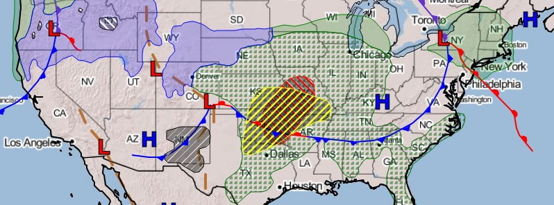
Image credit: WPC/SPC/NHC
Severe storms are expected to develop over central to southern Plains into the Ozarks Monday afternoon into the evening, rising the threat of large hail, damaging wind gusts and tornadoes.
A wave of low pressure over the Central/Southern High Plains on Monday, May 2, 2022, will move eastward to the northern Mid-Atlantic by Wednesday, May 4. In addition, moisture from the Western Gulf of Mexico will move northward over the Southern/Central Plains, NWS Ziegenfelder noted.1
The associated boundary and moisture will aid in destabilizing the atmosphere producing showers and thunderstorms from the Central High Plains to the Southern Plains.
Therefore, the SPC has issued an Enhanced Risk of severe thunderstorms over parts of the Central/Southern Plains through Tuesday morning, May 3.
The hazards associated with these thunderstorms are frequent lightning, severe thunderstorm wind gusts, hail, and a few tornadoes.
In addition, there is an increased risk for EF2 to EF5 tornadoes and large hail, 5 cm (2 inches) or greater over the area.
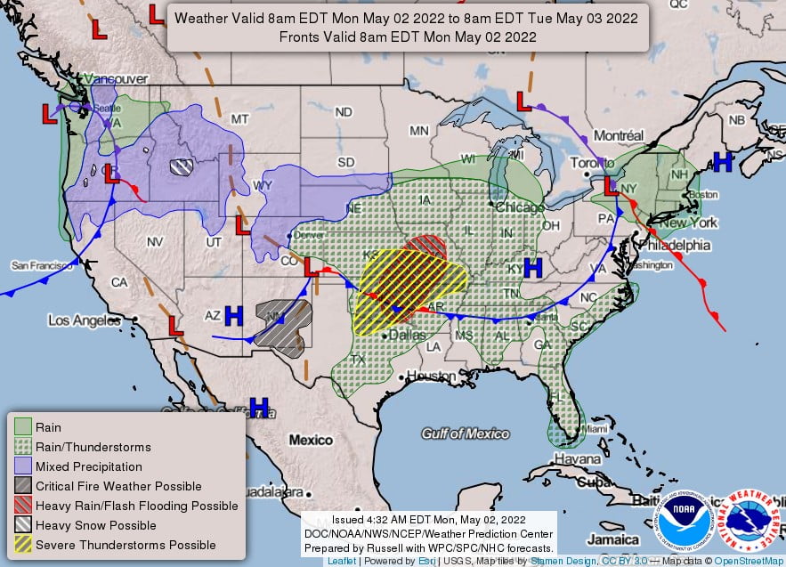
In addition, the threat of excessive rainfall increases over parts of the Central/Southern Plains and Middle/Lower Mississippi Valley through Tuesday morning.
Therefore, the WPC has issued a Slight Risk of excessive rainfall over parts of Central/Southern Plains and Middle/Lower Mississippi Valley through Tuesday morning.
The associated heavy rain will create mainly localized areas of flash flooding, with urban areas, roads, and small streams being the most vulnerable.
Furthermore, the upper-level energy associated with the system will aid in producing light snow over parts of the Central Rockies and snow/rain over the Central Plains.
Additionally, cold high pressure will build in the system s wake, allowing temperatures to become 5 to 14 °C (10 to 25 °F) below average over Northern/Central Plains and the Upper Mississippi Valley.
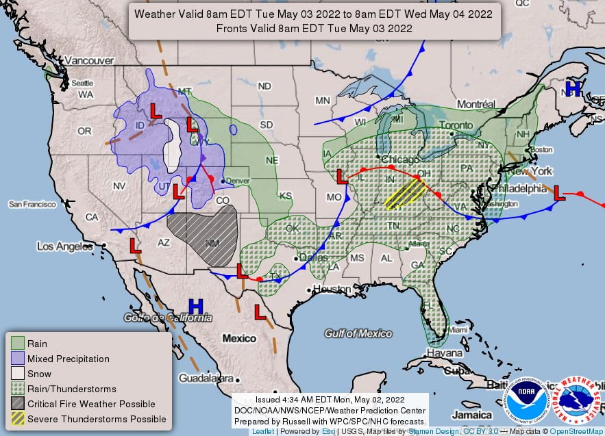
On Tuesday, as the front moves eastward, the threat of severe thunderstorms moves eastward to the Ohio Valley. Ahead of the front, moisture will stream into the Ohio Valley, aiding in destabilizing the atmosphere.
Therefore, the SPC has issued a Slight Risk of severe thunderstorms over parts of the Ohio Valley on Tuesday into Wednesday morning. The hazards associated with these thunderstorms are frequent lightning, severe thunderstorm wind gusts, hail, and a few tornadoes.
In addition, moderate to heavy rain will be associated with these thunderstorms, and the storms will be going over areas sensitive to excessive rainfall.
Therefore, the WPC has issued a Marginal Risk of excessive rainfall over the Lower Great Lakes parts into the Central Appalachians on Tuesday into Wednesday morning.
The associated heavy rain will create localized areas of flash flooding, affecting areas that experience rapid runoff with heavy rain.
References:
1 Short Range Forecast Discussion – NWS Weather Prediction Center College Park MD – 408 AM EDT Mon May 02 2022
I'm a dedicated researcher, journalist, and editor at The Watchers. With over 20 years of experience in the media industry, I specialize in hard science news, focusing on extreme weather, seismic and volcanic activity, space weather, and astronomy, including near-Earth objects and planetary defense strategies. You can reach me at teo /at/ watchers.news.
Commenting rules and guidelines
We value the thoughts and opinions of our readers and welcome healthy discussions on our website. In order to maintain a respectful and positive community, we ask that all commenters follow these rules.