
Earth from Orbit: Volcanic eruption at Soufriere St. Vincent
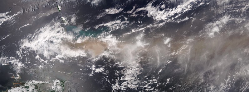
Image credit: NOAA
La Soufrière volcano on the Caribbean island of Saint Vincent began erupting on April 9, 2021, spewing ash at least 7.6 km (25 000 feet) above sea level. The volcano continued to erupt over the next several days, with multiple violent explosions, allowing satellites to capture stunning imagery of the eruptions and provide critical monitoring of the resulting volcanic emissions and ash clouds. La Soufrière last erupted in 1979 (VEI 3).
Ash blanketed Saint Vincent and winds carried ash to Barbados, about 200 km (120 miles) east, NOAA and NASA scientists noted on April 15, adding the region is preparing for possibly weeks of ashfall events.
A violent eruption on April 12 generated pyroclastic flows, a high-density mix of hot lava blocks, pumice, ash, and volcanic gas that moves at very high speeds down volcanic slopes. The eruptions also caused widespread power outages and evacuations.
Volcanic emissions often contain gasses and volcanic ash and generate complex clouds that can affect local, regional, and even global weather. Given the remote location of most volcanoes and the rapid formation and expansion of volcanic clouds, geostationary satellites, like NOAA’s GOES-16 and GOES-17, are the primary tool for monitoring volcanic clouds.
Because they orbit 35 785 km (22 236 miles) above Earth’s equator, at the same speed Earth rotates, GOES satellites have a constant view of the same area. This means they can monitor volcanic eruptions in near real-time, making timely and accurate detection and tracking of volcanic ash which is critical for maintaining safety and minimizing economic loss.
Volcanic ash rose up to 16 km (52 000 feet) above sea level over the past couple of days, according to Washington VAAC.
"At those altitudes, these aerosols [from volcanoes and smoke from wildfires] can stay in the atmosphere for a long time, and easily circle the Earth for days, weeks, and even months, and their presence can affect the radiation reaching the Earth’s surface, and therefore temperature, said NASA’s atmospheric scientist Colin Seftor.
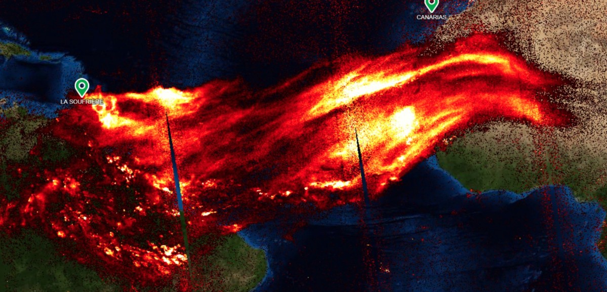
SO2 produced by the eruption at La Soufriere volcano acquired on April 13, 2021. Credit: Copernicus EU/Sentinel-5P, Adam Platform, Antonio Vecoli
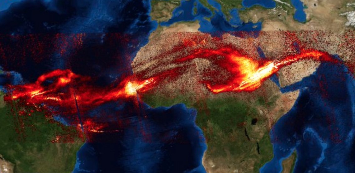
SO2 produced by the eruption at La Soufriere volcano acquired on April 15, 2021. Credit: Copernicus EU/Sentinel-5P, Adam Platform, Antonio Vecoli
Read more:
Red alert issued for La Soufriere volcano, evacuation ordered, St. Vincent and the Grenadines – April 9, 2021
Powerful explosive eruption at La Soufriere volcano, ash to 12 km (40 000 feet) a.s.l., St. Vincent and the Grenadines – April 9, 2021
Vincentians waking up to extremely heavy ashfall and strong sulfur smell, St. Vincent and the Grenadines – April 10, 2021
Massive power outage following another explosive event at La Soufriere volcano, ash rising up to 16 km (52 000 feet) a.s.l., St. Vincent – April 11, 2021
New massive eruption at Soufriere St. Vincent, SO2 emissions spreading over two continents – April 13, 2021
I'm a dedicated researcher, journalist, and editor at The Watchers. With over 20 years of experience in the media industry, I specialize in hard science news, focusing on extreme weather, seismic and volcanic activity, space weather, and astronomy, including near-Earth objects and planetary defense strategies. You can reach me at teo /at/ watchers.news.
Commenting rules and guidelines
We value the thoughts and opinions of our readers and welcome healthy discussions on our website. In order to maintain a respectful and positive community, we ask that all commenters follow these rules.