
Massive power outage following another explosive event at La Soufriere volcano, ash rising up to 16 km (52 000 feet) a.s.l., St. Vincent
Featured image: Volcanic ash produced by St. Vincent on April 10, 2021. Credit: NASA/NOAA Suomi NPP/VIIRS
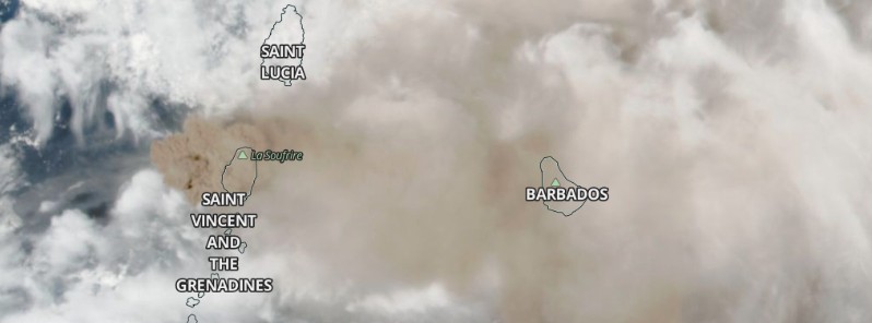
The majority of St. Vincent and the Grenadines is without power and covered in ash on April 11, 2021, following another explosive event at La Soufriere volcano.
Volcanic ash is rising up to 16 km (52 000 feet) above sea level and extending up to 3 000 km (1 850 miles), especially to the ENE but becomes rather diffuse, the Washington VAAC reported at 00:59 UTC on April 11.
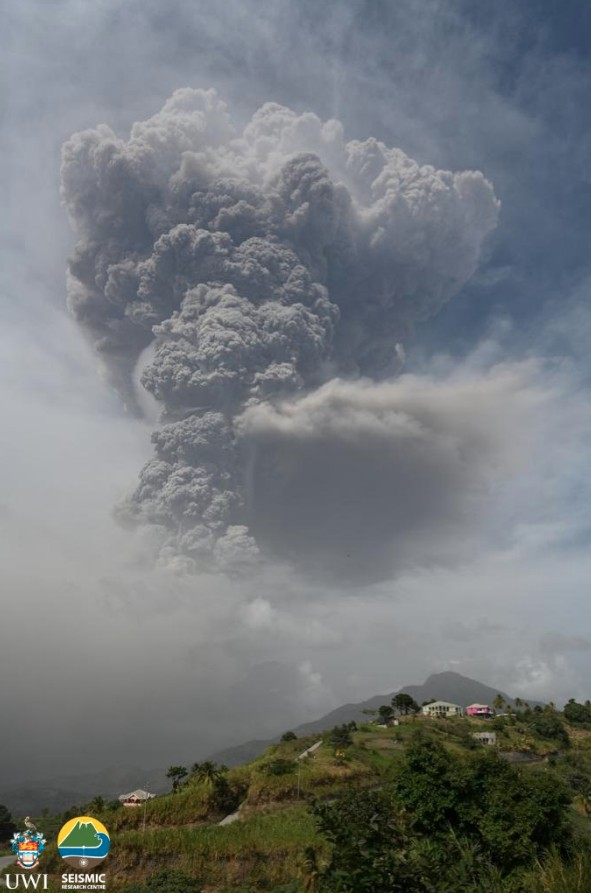
Image credit: UWI-SRC
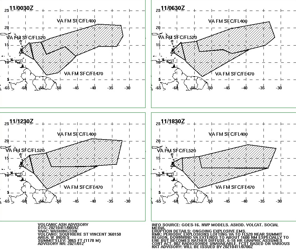

Image credit: USGS/Landsat-8, TW. Acquired April 9, 2021
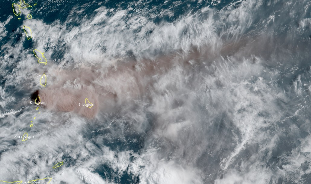
Volcanic ash produced by La Soufriere volcano, St. Vincent and the Grenadines. Credit: NOAA/GOES-16, RAMMB/CIRA, TW
The National Emergency Management Organization (NEMO) is urging residents with respiratory problems to take necessary precautions to remain safe and healthy and drivers to be careful on the roads which have become treacherous as a result of the ash flow from the volcano.
Volcanic activity (Soufriere) continues on St. Vincent today as seen in the animation below. Animated clockwise from top left are GOES-E CIMSS natural color, IR, SO2, and Ash products. pic.twitter.com/M7lTQtxQVW
— NWS OPC (@NWSOPC) April 10, 2021
Where parts of the #seashore of #StVincent is hidden in the ash of La #Soufriere's #Volcano #Eruption pic.twitter.com/ke2BYRtarC
— Juan Goulbourne (@GoulbourneJuan) April 11, 2021
My brother's video of the eruption of La Soufriere in St. Vincent. To all our Vincy family and friends stay safe. Stay safe. #thegrenadines #stvincentvolcano #stvincent pic.twitter.com/mBfPGavSox
— TNLewis (@tnsweetdreams) April 10, 2021
Sandy bay 10/05/2021 pic.twitter.com/K5b8ZRQI3U
— Agent Eddie (@agent_eddie) April 10, 2021
The landscape of beautiful #stvincent is shrouded in #ash from overnight #explosions and #ashventing from #lasoufriere #volcano #still-dangerous @uwiseismic pic.twitter.com/tvE1NZF6mC
— richard robertson (@VincieRichie) April 11, 2021
Video on the left was taken by me on February 17th 2021.
Video on the right was taken this morning April 10th 2021. #LaSoufrière #Volcano #Eruption #StVincent #VolcanicEruption #Explosion #AshFall pic.twitter.com/vnwD4NHvrw— འօʍąìղ (@whoshottya) April 10, 2021
Abc highway between Warrens and Hothersal in Barbados earlier today. pic.twitter.com/oj9CkXgD7Y
— Lavern King (@Lavern_King) April 10, 2021
#Barbados the morning after the #volcano eruptions in #StVincent
Prayers to all affected pic.twitter.com/CA70aDuaGt— Island Fit 246 (@luv2run25) April 10, 2021
Fresh scoria from #lasoufriere #svg collected at #rabaccariver ~7.4km from #volcano @uwiseismic pic.twitter.com/5qu3T6SP6O
— richard robertson (@VincieRichie) April 11, 2021
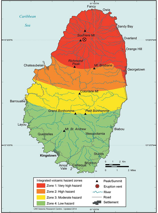
Volcanic Hazard Map – St. Vincent.
The map only shows hazard zone on land. However, lahars and pyroclastic falls, flows and surges will also impact areas offshore to varying degrees, and as such, the hazard zones must be envisaged as extending some distance offshore.
Hazard Zone 1 (Red Zone) – Very High Hazard:
This includes all areas expected to experience maximum damage in the short term and is the zone where all hazardous events have their greatest influence. It is defined by the zone of expected total destruction from pyroclastic flows, surges, and mudflows and by the zone of maximum expected damage from all projectiles. This zone is likely to experience more than 30 cm (12 inches) of ash. During the course of an eruption, this zone would be unsuitable for human habitation.
Hazard Zone 2 (Orange Zone) – High Hazard:
This includes all areas of moderate pyroclastic flow and surge hazard, areas within the 5 km (3.1 miles) projectile zone, and areas likely to experience between 10 and 30 cm (4 – 12 inches) of ashfall. These areas will be affected in a similar manner as Zone 1 during large scale eruptions.
Hazard Zone 3 (Yellow Zone) – Moderate Hazard:
This zone will be free from the effects of flows and surges but will be affected by 5 to 10 cm (2 – 4 inches) thick ashfalls, minor earthquakes and lightning strikes. This zone will experience significantly less physical damage than Zones 1 and 2.
Hazard Zone 4 (Green Zone) – Low Hazard:
This zone includes areas likely to be relatively safe from hazardous events, except for minor ashfall of less than 5 cm (2 inches). Crop damage and disruption of water supply due to ashfall will be the main effect but other physical damage will be minimal.
Geological summary
Soufrière St. Vincent is the northernmost and youngest volcano on St. Vincent Island. The NE rim of the 1.6 km (1 mile) wide summit crater is cut by a crater formed in 1812.
The crater itself lies on the SW margin of a larger 2.2 km (1.3 miles) wide Somma crater, which is breached widely to the SW as a result of slope failure.
Frequent explosive eruptions since about 4 300 years ago produced pyroclastic deposits of the Yellow Tephra Formation, which blanket much of the island.
The first historical eruption took place in 1718; it and the 1812 eruption produced major explosions.
Much of the northern end of the island was devastated by a major eruption in 1902 that coincided with the catastrophic Mont Pelée eruption on Martinique.
A lava dome was emplaced in the summit crater in 1971 during a strictly effusive eruption, forming an island in a lake that filled the crater prior to an eruption in 1979.
The lake was then largely ejected during a series of explosive eruptions, and the dome was replaced with another. (GVP)
I'm a dedicated researcher, journalist, and editor at The Watchers. With over 20 years of experience in the media industry, I specialize in hard science news, focusing on extreme weather, seismic and volcanic activity, space weather, and astronomy, including near-Earth objects and planetary defense strategies. You can reach me at teo /at/ watchers.news.
Wait until Yellowstone erupts, and then you will see the amazing height of ash
First point: I doubt it will erupt in 1,000 years.
Second point: If you live in North America and Yellowstone does erupt then have a good chance of never seeing the heights of the ash cloud, you’d be dead. However, future archeologists would puzzle over your bone, like they do at Pompeii.