
Ice storm warnings in effect for portions of Nebraska and Iowa, U.S.
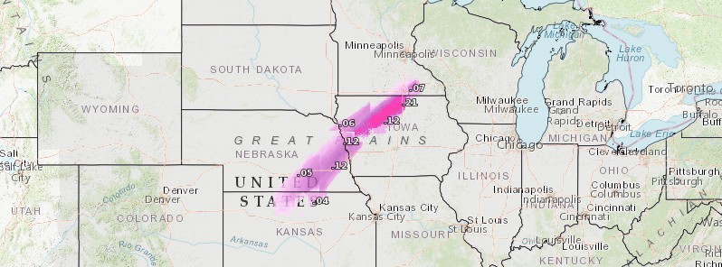
Featured image: Ice accumulation in inches for November 10, 2020. Credit: NWS, TW
A swath of freezing rain and sleet may lead to a period of heavy snow from eastern Nebraska into northern Wisconsin on Tuesday, November 10, 2020, NWS warns.
- Ice Storm Warning is in effect until 15:00 CST on November 10 for portions of east-central and northeast Nebraska and west-central Iowa.
- NWS forecasters warned significant icing is expected with additional snow accumulations of 25 – 50 mm (1- 2 inches) and ice accumulations of around 6 mm (0.25 inches).
- Power outages and tree damage are likely due to ice – prepare.
- Travel could be difficult — due to downed trees and powerlines — and is strongly discouraged. If you must travel, keep an extra flashlight, food and water in your vehicle in case of an emergency.
Precipitation will change to all snow by Tuesday morning and will continue into at least the first half of the day on Tuesday, NWS office in Hastings, Nebraska said.
"Colder air accompanying a strong cold front will bring the potential for accumulating snow to much of the area, along with the potential for a wintry mix including freezing rain and sleet."

Ice accumulation in inches for November 10, 2020. Credit: NWS, TW
"Anomalously warm air will linger across the Midwest and Northeast ahead of an approaching low pressure system from the Plains," NWS forecaster Kebede said.
Temperatures are likely to be warm enough to contribute to widespread records being broken from the Midwest to the Northeast, where high temperatures are expected to be up to 22 °C (40 °F) above average today.
The warm airmass will recede into the Northeast and Mid-Atlantic on Wednesday, November 11 where high temperatures are expected to be similarly anomalous than they were on Tuesday.
A weak low pressure system approaching the Pacific Northwest will be the focus for heavy snow across the Cascades and Northern Rockies over the next 2 days.
Snowfall totals of over 30 cm (1 feet) are expected for those areas. Meanwhile, the main low pressure system during the last few days will continue to be the focus for rain and thunderstorms as it moves east today.
Some thunderstorms may be severe according to The Storm Prediction Center.
Heavy snow is a possibility on the backside of this system, particularly over the Upper-Midwest. Snowfall totals may reach 15 cm (6 inches) with locally higher amounts possible.
Freezing rain/ice accumulations may reach 2.5 mm (0.1 inches) across parts of the Upper-Mississippi Valley.
Winter Weather Watches/Advisories are currently in effect for the Plains and Upper Midwest.
By the time the Plains system reaches the East Coast on Wednesday, it will have dropped up to 75 mm (3 inches), with locally higher amounts possible, of rainfall over the Mid-Atlantic/Southeast.
Therefore, a Slight Risk of Excessive Rainfall leading to Flash Flooding is expected over the Mid-Atlantic on Wednesday.
I'm a dedicated researcher, journalist, and editor at The Watchers. With over 20 years of experience in the media industry, I specialize in hard science news, focusing on extreme weather, seismic and volcanic activity, space weather, and astronomy, including near-Earth objects and planetary defense strategies. You can reach me at teo /at/ watchers.news.
Commenting rules and guidelines
We value the thoughts and opinions of our readers and welcome healthy discussions on our website. In order to maintain a respectful and positive community, we ask that all commenters follow these rules.