
At least 13 killed as worst rains in more than 100 years flood Hyderabad, India
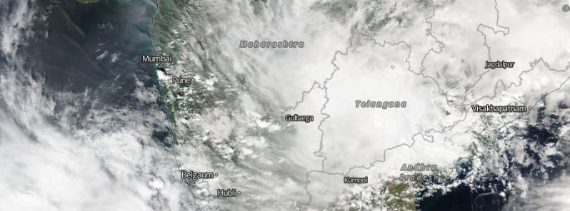
Image credit: NOAA-20/VIIRS. Acquired October 13, 2020
A deep depression that crossed Andhra Pradesh coast near Kakinada on Tuesday, October 13, 2020, brought unprecedented rainfall over Hyderabad, capital of the Indian state of Telangana, from Tuesday night to Wednesday morning, claiming the lives of at least 13 people. Authorities are urging residents to stay indoors and remain cautious as more heavy rainfall is expected in the days ahead. Meteorologists said the rains that hit the region are rare and unseasonal.
According to the India Meteorological Office, Ghatkesar on the city outskirts received record rainfall of 322 mm (12.6 inches) from Tuesday night to Wednesday morning. This is the heaviest rainfall the city has seen in more than a century.
During the same period, Hayathnagar recorded 294 mm (11.5 inches) and Hastinapuram 283 mm (11.1 inches).
The resulting floods submerged dozens of colonies in the city and its suburbs, forced authorities to deploy rescue boats and evacuate hundreds of people from their homes.
Local media reported hundreds of vehicles stranded on the Hyderabad-Vijayawada highway. Traffic was slow or brought to a standstill on the Hyderabad-Bengaluru highway and toward Hyderabad Airport at Shamshabad.
Some parts of the city were without power for over 12 hours, TWC India reports.
According to local media reports, 9 people were killed and 3 others injured when a wall collapsed and fell on two houses in Bandlaguda in the old city of Hyderabad. 2 people drowned and 2 others went missing in the Gaganpahad area in Shamshabad on the outskirts of Hyderabad. 2 more persons were feared killed in Abdullahpur, also on the outskirts.
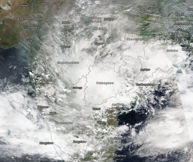
Image credit: NOAA-20/VIIRS. Acquired October 13, 2020
The system responsible for record rainfall over Hyderabad is expected to continue moving in a WNW direction towards Maharashtra and will get weaken further into a low pressure area before the end of the day.
Rain activities will increase over most parts of Marathwada, adjoining part of Vidarbha, and over many parts of Madhya Maharashtra. Rains will start subsiding over Marathwada by the evening of October 14 (LT) as the low pressure area will move further westwards toward Konkan and Goa. On October 14 and 15 many parts of Konkan and Goa including Mumbai may get intense rain and shower activities, SkymetWeather meteorologists warn.
"These rains are considered as unseasonal rains, particularly for Telangana and Maharashtra. However, Telangana sometimes receives moderate to heavy showers in the wake of depression of cyclones forming over the Bay of Bengal but for Maharashtra, these rains are rare and unseasonal."
I'm a dedicated researcher, journalist, and editor at The Watchers. With over 20 years of experience in the media industry, I specialize in hard science news, focusing on extreme weather, seismic and volcanic activity, space weather, and astronomy, including near-Earth objects and planetary defense strategies. You can reach me at teo /at/ watchers.news.
Kuzunki..The content made me interested.. will you please explain in detail or mail me..
just spending a few minutes looking at the image at the top enlarging it, they have been playing weather mod, you can see the trails of the ships of shame dumping “bunker”fuels into the cloud cover. Millions of tons of it. This can only be done by a navy or a dark shipping company that contracts to pump this “fake” cloud, usually at night but anywhere anytime is the operation. causing particle binding, they can get rain, too much of it, as china’s CCP ego found out but wont admit !! the image tells us lots, the rain was fabricated, and miscalculated, not being a precise technology, this much rain falls when too many HAARP arrays and such are active. the ships and planes contributing to this mess as usual not seen. but this is seen off the west coast of the US, where thousands of kilometers of ocean are constantly being deliberately polluted, in some vain attempt to steer storms, elicit rains, etc. The College Du Page has a very insightful web page, where you can examine this man made phenomena. Roosevelt addressed a Campus in 1952, that weather modification was the future, and that work was very advanced. China, only recently completed the worlds largest, most disastrous array across the Hymalayas. This is NOT over. Gaia is going to respond. this is a beginning. There has already been one huge flooding deluge that devastated this planet of all life, are we going to see another, brought on by our “advanced ” civilisation??” We must be the most unbelievable species that ever existed, going down in the annals of cosmic history , that we polluted the planet so baldy, it died. We died. the only way to contribute to the damage that has been done to the earth in our time, is to STOP IT GLOBALLY…. NOW!