
Volcanic activity remains high at Nishinoshima, Japan
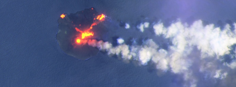
Image credit: USGS/Landsat-8, Antonio Vecoli. Acquired June 6, 2020
Volcanic activity remains high at the Japanese Nishinoshima volcano, with large lava flows and ash emissions. Nishinoshima is the summit of a massive submarine volcano that has prominent satellitic peaks to the S, W, and NE.
A near-crater warning is in effect since December 16, 2019. The marine exclusion zone was defined as a radius of about 2.6 km (1.6 miles) from the island.
The satellite image below was acquired by Landsat-8 on June 6, 2020, and processed by remote sensing engineer Antonio Vecoli:
![]()
![]()
Image credit: USGS/Landsat-8, Antonio Vecoli. Acquired at 01:05 UTC on June 6, 2020
Nishinoshima (meaning 'western island' in Japanese) is a volcanic island located around 940 km (580 miles) SSE of Tokyo. It's a part of the Volcano Islands arc.
Originally the above-water part of the ridge of an underwater caldera, Nishinoshima was enlarged in 1974 after fresh eruptions created a new section of the island. Another eruption that began in November 2013 further enlarged the island and attracted worldwide attention.
A volcanic cone soon formed, raising to an estimated height of 142 m (466 feet) by July 2016. The eruptions ceased by November 2015, but emissions of volcanic gases continued for several months afterward.
In 2016, the island was about 2.7 km2 (1.0 mi2) but further eruptions since 2017 increased the island size to more than 2.89 km2 (1.12 mi2).
Animation courtesy: JAXA
Thanks to 3rd Regional Coast Guard Headquarters of the Japan Coast Guard we can see fresh images of the island, cinder cone and lava flows acquired June 7, 2020:
![]()
Nishinoshima volcano on June 7, 2020. Image credit: JCG
![]()
Nishinoshima volcano on June 7, 2020. Image credit: JCG
![]()
Nishinoshima volcano on June 7, 2020. Image credit: JCG
Geological summary
The small island of Nishinoshima was enlarged when several new islands coalesced during an eruption in 1973-74. Another eruption that began offshore in 2013 completely covered the previously exposed surface and enlarged the island again. Water discoloration has been observed on several occasions since.
The island is the summit of a massive submarine volcano that has prominent satellitic peaks to the S, W, and NE. The summit of the southern cone rises to within 214 m (702 feet) of the sea surface 9 km (5.6 miles) SSE. (GVP)
I'm a dedicated researcher, journalist, and editor at The Watchers. With over 20 years of experience in the media industry, I specialize in hard science news, focusing on extreme weather, seismic and volcanic activity, space weather, and astronomy, including near-Earth objects and planetary defense strategies. You can reach me at teo /at/ watchers.news.
Commenting rules and guidelines
We value the thoughts and opinions of our readers and welcome healthy discussions on our website. In order to maintain a respectful and positive community, we ask that all commenters follow these rules.