
Very rare derecho hits central Rockies and northern Plains
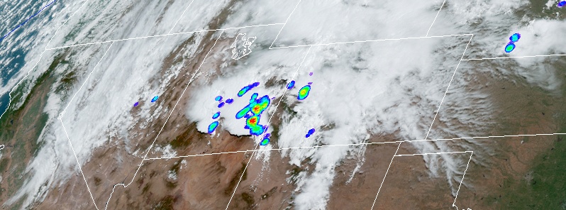
Image credit: NOAA/GOES-16. Acquired 16:20 UTC on June 6, 2020.
Widespread, long-lived wind storm known to meteorologists as 'derecho' affected the central Rockies and northern Plains on Saturday, June 6, 2020.
Derechos are very rare for parts of Utah, Wyoming, and Colorado, NWS Storm Prediction Center said. In fact, only two other Derechos are well-documented west of the Rockies — first on May 31, 1994 and the second on June 1, 2020.
The 2020 central Rockies/northern Plains derecho began at around 15:00 UTC (09:00 MDT) on June 6. The last severe wind report was received at 02:52 UTC on June 7 (20:52 MDT).
Severe wind reports span at least 1 200 km (750 miles) from far southeastern Utah to southwest North Dakota.
The storm produced severe wind reports for nearly 12 hours and tracked northeast at an average pace of 96 km/h (60 mph).
The highest measured gust was 177 km/h (110 mph) at Winter Park Ski Area in Grand County, Colorado.
Rare derecho stretching from Utah to the Dakotas today.
A Rocky Mountain special. pic.twitter.com/tkNC8lLRmj
— Dakota Smith (@weatherdak) June 7, 2020
A derecho affected the central Rockies and northern Plains on Saturday (6/6/20). Derechos are very rare for parts of UT, WY & CO. In fact, only two other derechos are well-documented west of the Rockies. Interested in learning more about derechos? Visit: https://t.co/Na0e8JB4bc pic.twitter.com/XcUI8j5pQQ
— NWS Storm Prediction Center (@NWSSPC) June 8, 2020
Based on @akrherz’s archive, these are the two largest warning polygons issued by @NWSBoulder by quite a margin #cowx pic.twitter.com/OaxOFJOYTp
— Russ Schumacher (@russ_schumacher) June 6, 2020
Indeed they are. Here’s a Derecho Climatology from SPC. Derechos for the High Plains are rare. #cowx https://t.co/KLOEA2XrPg pic.twitter.com/9Kff0Hqw3r
— Sam Ng (@DocWX) June 7, 2020
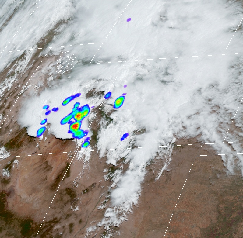
Image credit: NOAA/GOES-16. Acquired 16:20 UTC on June 6, 2020
"What appeared to be a fairly typical Colorado afternoon of wind-producing storms Saturday morphed into possibly the most widespread wind-specific thunderstorm event in the state’s recorded history," said Russ Schumacher, Colorado's state climatologist.
"In the storm data record from 1955 – 2018, the most severe wind reports on a single day in Colorado is 30, on May 22, 2006. On Saturday, there were 91. The most significant wind gusts (120 km/h / 75 mph or greater) on a single day was 7, on a couple of different occasions. On Saturday, there were 17," Schumacher said.
"I think it’s fair to say we’ve never had such a widespread damaging thunderstorm wind event in Colorado, at least since reliable records have been collected."
I'm a dedicated researcher, journalist, and editor at The Watchers. With over 20 years of experience in the media industry, I specialize in hard science news, focusing on extreme weather, seismic and volcanic activity, space weather, and astronomy, including near-Earth objects and planetary defense strategies. You can reach me at teo /at/ watchers.news.
Commenting rules and guidelines
We value the thoughts and opinions of our readers and welcome healthy discussions on our website. In order to maintain a respectful and positive community, we ask that all commenters follow these rules.