
Tropical Storm “Cristobal” makes landfall in Louisiana, U.S.
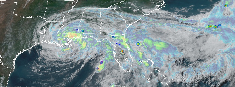
Featured image: Tropical Storm "Cristobal" making landfall in Louisiana, U.S. at 22:00 UTC on June 7, 2020. Credit: NOAA/GOES-16, RAMMB/CIRA
The center of Tropical Storm "Cristobal" made landfall in southeast Louisiana at 22:00 UTC (17:00 CDT) on June 7, 2020, between the mouth of the Mississippi River and Grand Isle with maximum sustained winds near 85 km/h (50 mph) and minimum central pressure of 992 hPa. Since that time, the storm has turned north-northwestward with the center passing very near New Orleans. Cristobal is forecast to weaken into tropical depression in the hours ahead, with its remnants tracking north through the Mississippi Valley all the way to Canada by Wednesday, June 10.
- Cristobal formed from the remnants of Tropical Storm "Amanda" — the first named storm of the 2020 Pacific hurricane season.
- Cristobal is the third named storm of the 2020 Atlantic hurricane season, the earliest third named storm in the Atlantic, beating the previous record set by Tropical Storm "Colin" which formed on June 5, 2016, and the first June Atlantic tropical cyclone to make landfall in Mexico since Tropical Storm "Danielle" in 2016.
- The National Hurricane Center (NHC) forecasts Cristobal tracking farther west across Wisconsin than any other post-tropical system on record since the mid-1800s.
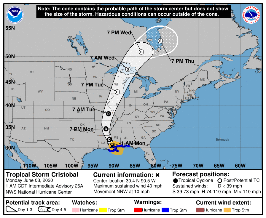
At 00:00 UTC (19:00 CDT) on June 8, its center was located about 55 km (35 miles) SSE of New Orleans, Louisiana. The storm had maximum sustained winds near 85 km/h (50 mph) and continued moving N at 11 km/h (7 mph) with minimum central pressure of 993 hPa.
Winds decreased to 65 km/h (40 mph) by 06:00 UTC when Cristobal's center was located about 55 km (35 miles) NW of New Orleans. The storm was moving at 17 km/h (10 mph) and had minimum central pressure of 994 hPa. The storm is forecast to weaken to a tropical depression during the next several hours.
This general motion with an increase in forward speed is expected through today. A turn toward the north is forecast on tonight, followed by a northeastward motion late Tuesday and Wednesday.
A Storm Surge Warning is in effect for the Mouth of the Mississippi River to Ocean Springs Mississippi; and Lake Borgne. A Tropical Storm Warning is in effect for Morgan City, Louisiana to the Okaloosa/Walton County Florida line; and Lake Pontchartrain and Lake Maurepas.
On the forecast track, the center of Cristobal will move farther inland across southeastern Louisiana for the next several hours, northward across Arkansas and Missouri this afternoon (LT) into Tuesday, and then move over Wisconsin Tuesday night and into Canada on Wednesday, June 10.
Additional gradual weakening is anticipated while the cyclone moves over the central U.S. through Tuesday, but some slight re-strengthening is possible due to strong baroclinic forcing during the extratropical transition around midweek.
As the system completes its extratropical transition, strong gusty winds are possible mid-week behind an associated front over portions of the Midwest and Great Lakes regions.
Although Cristobal has begun weakening, tropical-storm-force winds and life-threatening storm surge is expected to continue over a portion of the northern Gulf coast overnight. Heavy rains associated with the system will also spread over portions of the central United States over the next couple of days.
The combination of a dangerous storm surge and the tide will cause normally dry areas near the coast to be flooded by rising waters moving inland from the shoreline, NWS noted.
The water could reach the following heights above ground somewhere in the indicated areas if the peak surge occurs at the time of high tide:
Mouth of the Mississippi River to Ocean Springs MS including Lake Borgne: 0.9 – 1.5 m (3 – 5 feet)
Morgan City LA to Mouth of the Mississippi River: 0.3 – 0.9 m (1 – 3 feet)
Ocean Springs MS to Okaloosa/Walton County Florida line, including Mobile Bay and Pensacola Bay: 0.3 – 0.9 m (1 – 3 feet)
The deepest water will occur along the immediate coast in areas of onshore winds and will likely extend along the coast well to the east of the center. Surge-related flooding depends on the relative timing of the surge and the tidal cycle, and can vary greatly over short distances.
Tropical storm conditions are expected within the Tropical Storm Warning area along the northern Gulf Coast for the next several hours.
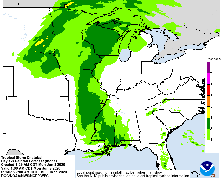
Cristobal is expected to produce storm total rainfall accumulations of 125 – 250 mm (5 to 10 inches) across portions of the central to eastern Gulf Coast into the Lower Mississippi Valley, with isolated amounts to 380 mm (15 inches).
Rainfall totals of 50 – 100 mm (2 to 4 inches) with local amounts to 150 mm (6 inches) are expected across portions of the Mid to Upper Mississippi Valley and Northern Plains near and in advance of Cristobal.
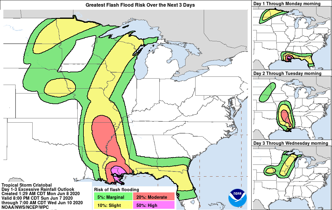
This rainfall will likely lead to flash flooding and widespread flooding on smaller streams across portions of the central Gulf Coast into the Lower Mississippi Valley. New and renewed significant river flooding is possible along the central Gulf Coast and into the Mississippi Valley.
Isolated tornadoes are still possible this morning across southeastern Louisiana, southern Mississippi, and southern Alabama.
Swells generated by Cristobal will affect portions of the northern and eastern Gulf coast through today. These swells are likely to cause life-threatening surf and rip current conditions.
Three tornadoes touched down in Florida on Saturday, June 6, with one coming close to impacting downtown Orlando.
The Orlando tornado was determined an EF-1. It touched down near Ferncreek and Lake Margaret but began as a waterspout on Lake Conway and lifted near Lake Lawsona. The tornado intensified as it moved north, with winds estimated around 62 – 65 km/h (100 – 105 mph).
There are no reports injuries.
WATCH: Video of possible tornado over Lake Conway in Orlando. pic.twitter.com/tynvuNMUN1
— Justin Warmoth (@News6Justin) June 6, 2020
Wow! Tornado touchdown in #orlando tonight! #seriousweather #tornado #stormseason #stormchasersHQ #stormchaser pic.twitter.com/mQWahdP9SM
— Matt collis (@matt_golfer) June 7, 2020
Tornado East of Summerlin in Downtown Orlando. @WFTVWeather pic.twitter.com/Dl1rZtLH1E
— Wayne Allred (@wallred5) June 6, 2020
Two boys, aged 8 and 10, were killed after they were caught in an undertow and swept away by a rip current off the coast of Louisiana on June 5.
First responders in Hancock County, MS used a high-water vehicle to evacuate about 100 Silver Slipper Casino employees stuck at work after flooding blocked the roadway. Authorities said crews spent more than 3 hours taking employees from the casino entrance to the employee parking lot at Lakeshore Road and Lower Bay Road.
Water levels at Shell Beach, LA rose up to 1.9 m (6.2 feet) above normal tide level Sunday afternoon at Shell Beach, Louisiana. Storm surge in New Orleans surpassed 1 m (3.5 feet) on the south shore of Lake Pontchartrain Sunday afternoon (LT), causing water to pile up on Lakeshore Drive, TWC reported.
Storm surge caused water to cover roads near Waveland and Bay St. Louis, Mississippi, where water levels rose to nearly 1.8 m (6 feet) above normal Sunday afternoon.
Cristobal formed from the remnants of Tropical Storm "Amanda" — the second tropical cyclone and first named storm of the 2020 Pacific hurricane season — which killed at least 33 people and affected more than 500 000 in parts of Central America following its landfall in Guatemala on May 30, 2020. Amanda rapidly weakened after making landfall but its remnants emerged in the Gulf of Mexico and regenerated into Tropical Depression Three and then into Tropical Storm "Cristobal" on June 2.
Cristobal is the third named storm of the 2020 Atlantic hurricane season, the earliest third named storm in the Atlantic, beating the previous record set by Tropical Storm "Colin" which formed on June 5, 2016, and the first June Atlantic tropical cyclone to make landfall in Mexico since Tropical Storm "Danielle" in 2016.
Amanda caused flooding and landslides that affected hundreds of thousands across El Salvador, Guatemala, and Honduras.
Two of the fatalities occurred in Guatemala, where nearly 1 500 shelters have been opened for those affected.
In El Salvador, torrential rainfall caused major damage along the coastal cities as rivers became swollen, sweeping away buildings. 27 deaths were reported in the country, six of which died due to flash flooding and one from a collapsed home.
More than 900 houses were damaged across the nation, and 1 200 families were evacuated to 52 shelters across La Libertad, San Salvador, Sonsonate, and San Vicente.
In the capital city of San Salvador, 50 houses were destroyed and 23 vehicles fell into a sinkhole.
The UN Office for the Coordination of Humanitarian Affairs said on June 5 that there are about 150 000 affected people in El Salvador, 306 000 in Guatemala, and 1 200 in Honduras, where four deaths were also reported.
At 13:35 UTC on June 3, reports from an Air Force Reserve Unit Hurricane Hunter aircraft indicated that Cristobal had made landfall near Atasta, Mexico, just to the west of Ciudad del Carmen, with sustained winds of 95 km/h (60 mph).
Cristobal began to slowly weaken as the day went on while it pushed further southeast into the Mexican state of Campeche, signified by a decrease in thunderstorm activity near the center.
On June 4, it weakened into a tropical depression, with its satellite appearance degrading. The depression lost most of its banding features due to prolonged interaction with land, and most of its convection was limited to the northeastern quadrant.
Unexpectedly, the depression moved northward at a faster pace than forecast, resulting in it getting better organized on satellite imagery. Cristobal briefly entered Guatemala before starting to move northwards.
As it continued its northward motion, convection increased in the northern side of the system and it was re-upgraded to a tropical storm at 15:00 UTC on June 5.
Cristobal gradually intensified but lost its core tropical structure due to dry air and moderate wind shear, resulting in it having an asymmetric structure on satellite resembling that of a subtropical cyclone.
I'm a dedicated researcher, journalist, and editor at The Watchers. With over 20 years of experience in the media industry, I specialize in hard science news, focusing on extreme weather, seismic and volcanic activity, space weather, and astronomy, including near-Earth objects and planetary defense strategies. You can reach me at teo /at/ watchers.news.
Commenting rules and guidelines
We value the thoughts and opinions of our readers and welcome healthy discussions on our website. In order to maintain a respectful and positive community, we ask that all commenters follow these rules.