
Record-setting wave measured in the Adriatic Sea, Croatia
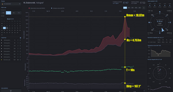
Image credit: HHI
A powerful Mediterranean storm named Victoria affected the Mediterranean Sea and surrounding countries, including Algeria, Tunisia, Italy, Slovenia and Croatia, this week. The storm produced many notable events, including the largest wave ever recorded in Croatia and the largest flood in Venice since the 1950s.
The largest wave, measuring 10.87 m (35.66 feet) was recorded near the island of Sveti Andrija, Elafiti Islands, Dubrovnik at 15:00 UTC on November 12, 2019 (Sea state 6; Hmax=10.87 m; Hs=4.75 m; T=10s; Dirp=167.1°).
The previous record was 10.80 m (35.43 feet) registered in February 1986 at PANON platform located in northern Adriatic.

Image credit: HHI
Although unofficial reports coming from the archipelago at the end of the 1980s mention waves larger than 11 m (36.08 feet), this is the first official confirmation of the largest wave.
"We've seen waves over 9 m (29.52 feet) over the past few months, but something like this has never been recorded," said Srđan Čupić, head of the Oceanographic department of Croatian Hydrographic Institute.
Theoretical calculations suggest the largest waves in the Adriatic Sea can reach up to 14 m (45.9 feet).
A wind gust of 134 km/h (83.2 mph) was registered at the meteorological station located in Marjan, Split on November 12. This is the third strongest wind gust registered at the station since the 1950s. In northern Adriatic, wind gusts reached as high as 150 km/h (93.2 mph).
Extreme sea levels were recorded by tide gauge stations Split and Ploče on November 13, 2019. At 03:02 UTC, tide gauge station Split measured a sea level of 1.515 m (4.97 feet) above tidal datum, or 91.1 cm (35.8 inches) above mean sea level.
This is the highest sea level measured since 1955, when this tide gauge station started continuous measurements.
At 02:29 UTC on the same day, tide gauge station Ploče measured a sea level of 2.128 m (6.98 feet) above tidal datum, or 88.7 cm (34.9 feet) above mean sea level. This is the highest sea level measured since 2002, when this tide gauge station started continuous measurements.
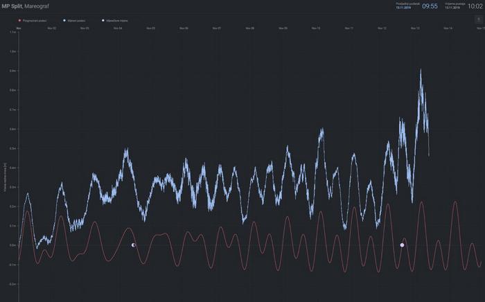
Image credit: HHI
In case you missed it, the same weather system produced the largest floods in Venice since the 1950s (Aqua Alta), submerging 85% of the city.
The water level reached 1.87 m (6.1 feet) which is the highest in 50 years and the second-highest on record (1.94 m / 6.3 feet in 1966). Official records in the city started in 1923.
Two fatalities have been reported – one elderly man was electrocuted after floods swept through his home on the island of Pellestrina, while another man was found lifeless in his home.
I'm a dedicated researcher, journalist, and editor at The Watchers. With over 20 years of experience in the media industry, I specialize in hard science news, focusing on extreme weather, seismic and volcanic activity, space weather, and astronomy, including near-Earth objects and planetary defense strategies. You can reach me at teo /at/ watchers.news.
Commenting rules and guidelines
We value the thoughts and opinions of our readers and welcome healthy discussions on our website. In order to maintain a respectful and positive community, we ask that all commenters follow these rules.