
Massive wildfires burning in Alberta, Canada
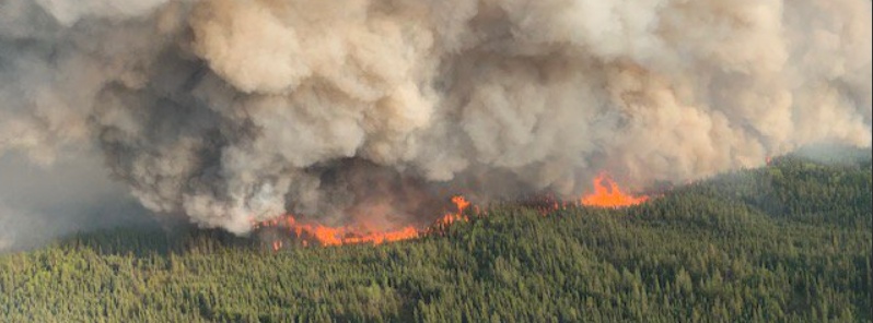
Image credit: Alberta Wildfire
Several wildfires have broken out through Northern Alberta Region, Canada since May 23, forcing authorities to evacuate thousands of people.
Provincial authorities reported 17 active fires on May 23, with the most affected area near the town of High Level, Mackenzie County where nearly 5 000 people have been evacuated. More than 92 000 hectares (227 000 acres) have been scorched.
A State of Local Emergency has been declared for the county.
The wildfire was rated as Level 6, the top of the wildfire intensity scale.
The Government of Alberta has issued a warning from a very high to an extreme fire danger across the Northern Alberta Region, including an extreme fire danger for the Slave Lake Forest Area.
According to Meteorological Service of Canada, smoke from wildfires in northern Alberta is causing poor air quality and reducing visibility, in the already affected areas.
"We can't always rely on our experience and the history of what we've seen in fire; we're moving into new territory," Mike Flannigan, a professor of wildland fire at the University of Alberta told CBC Radio's special Smoked Out.
"Lock doors and windows, take small personal belongings including pets, identification, medication cash," the provincial government said in an emergency alert. "Within your homes please ensure all fuel and gas appliances are shut off, and hot water tanks are turned down if able to."
Another wildfire sprung up over the weekend near a remote community in northwestern Alberta, which has been put on alert to evacuate on short notice, Global News reports.
The wildfire is 14 km (8.7 miles) SE of the community of Trout Lake and the nearby Peerless Lake First Nation. Alberta Emergency Alert said the communities should be prepared to evacuate if necessary and to follow the directions of local authorities.
A new wildfire has started 14 kilometers southeast of Trout Lake. It is classified as out of control and is estimated to be 300 hectares in size.
Visit https://t.co/9aBj4F74nd for the latest information. pic.twitter.com/YJTh8JIAls
— Alberta Wildfire (@AlbertaWildfire) May 27, 2019
According to Natural Resources Canada, about 3.4 million hectares of land was consumed by wildfires in 2017. This is well beyond the annual average. Ministry data shows in recent years fire destruction has steadily climbed in terms of area covered.
In 2013, for example, some 6 300 forest fires burned over 4.2 million ha (10.4 million acres). The following year, nearly 4.6 million ha (11.3 million acres) were scorched by about 5 200 wildfires.
Growing wildfire prompts evacuation of 5000 people in Alberta town, Canada. pic.twitter.com/U3gGfPMpfo
— Fourth Television (@4thtelevision) May 21, 2019
Firefighters continued to carry out a controlled burn around the town of High Level in Alberta, Canada yesterday in an effort to control the wildfire that has ravaged over 97,600 hectares of forest and threatened the small Canadian town. pic.twitter.com/uli77GV5yF
— BBC Weather (@bbcweather) May 24, 2019
Commenting rules and guidelines
We value the thoughts and opinions of our readers and welcome healthy discussions on our website. In order to maintain a respectful and positive community, we ask that all commenters follow these rules.