Salton Buttes lava domes: Mud volcano threatens railroad track and state highway, California
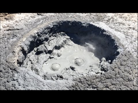
One of the mud geysers near the town of Niland, California's Imperial County, is growing rapidly, threatening nearby railroad track and state highway which may soon have to be closed.
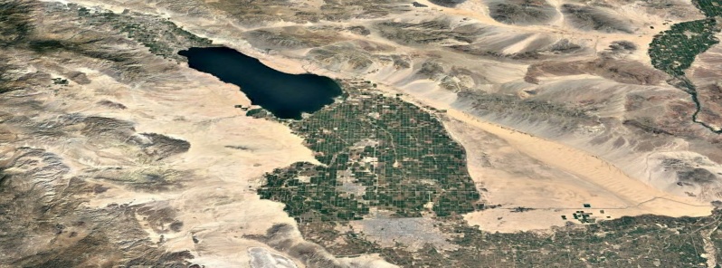
This area consists of a group of volcanoes in the Niland Field, known as Salton Buttes, Salton Sea Mud Volcanoes and locally as the Davis-Schrimpf Seep Field. You can explore the area in detail using map below.
The field is located close to the southeastern rim of the Salton Sea and consists of about 7 km2 (4.3 mi2)-long row of five lava domes, named Mullet Island, North Red Hill, Obsidian Butte, Rock Hill and South Red Hill. They are closely associated with a fumarolic field and a geothermal field, and there is evidence of buried volcanoes underground.
According to officials, one of the mud geysers in the field recently moved about 18 m (60 feet) in just one day and is now threatening crucial infrastructure in the area.
The geyser is located approximately 1 km (0.6 miles) south of the intersection of SR -111 (Highway 111) and Gillespie Road in Imperial County and is releasing water and carbon dioxide.

The geyser is located approximately 1 km (0.6 miles) south of the intersection of SR -111 (Highway 111) and Gillespie Road, just NNW of Mundo
"This natural-occurring geyser has been in existence since 1953," Imperial County officials said June 26, 2018. "In the past 11 years, the geyser has moved slowly however recently the rate of movement has increased and has been encroaching on the railroad."
The County of Imperial made an emergency declaration on June 26, 2018 due to the geyser migrating toward and threatening the Union Pacific Railroad (UPRR) railroad tracks, SR -111, a petroleum pipeline, fiber optic telecommunications lines and other buried utilities in the area.
Union Pacific Railroad is leading the effort to mitigate the situation by moving the fluid out of the area and is working closely with officials from the County of Imperial, Cal OES, Caltrans, and the Colorado River Basin Regional Water Quality Control Board.
A steel wall, about 23 m (75 feet) deep and 36 m (120 feet) long, was build during the summer. However, muddy fluids seeped under it during October and moved even closer to the tracks.
Alternate tracks were built and Pacific Union is considering building a bridge. However, State Route 111 in this area will most likely have to be closed and traffic diverted.
This area is being monitored by the California Volcano Observatory for possible future volcanic activity. Geophysical evidence shows that liquid magma is still present underneath the Salton Buttes.
Since the volcanoes have erupted in the past, there is present-day unrest, and there are areas of high population density nearby, the Salton Buttes are considered high-hazard volcanos.
Some geologists claim that its future eruptions may generate pyroclastic flows and pyroclastic surges, which could endanger people within 10 km (6.2 miles) of the vents.


The Salton Buttes lie within the Salton Trough, a tectonic depression formed by the San Andreas Fault and the San Jacinto Faults. The depression forms the northward extension of the Gulf of California, and is separated from it by the Colorado River Delta.
The age of the Salton Buttes has variously been considered to be late Pleistocene or early Holocene based on different dating techniques, according to the GVP.
Recent paleomagnetic dating calibrated by radiocarbon ages suggests that the Salton Buttes domes were erupted during an interval of about 500 years between about 2300 and 1800 years ago, with the possible exception of Mullet Island at the northern end of the field, which could be as much as 5000 years older.
The present-day saline Salton Sea was formed in the early 20th century by unintended flooding into the basin formerly occupied by Pleistocene Lake Cahuilla Lake during diversion of the Colorado River for irrigation purposes. The Salton Sea geothermal field produces saline brines.
Featured image: Salton Buttes, California. Credit: USGS/Landsat, ESA/Copernicus, Google, TW
Interesting stuff. Thanks for the info and the videos.