
Tropical Storm “Khanun” passing over Philippines, heading toward Hainan and flood-ravaged Vietnam
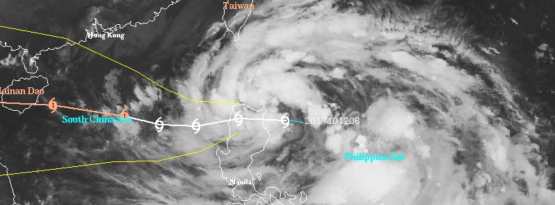
Featured image: Tropical Storm "Khanun" at 13:30 UTC on October 12, 2017. Credit: UW-CIMSS
Tropical Storm "Khanun" formed October 12, 2017 just east of the northern Philippines as the 20th named storm of the 2017 Pacific typhoon season, 24th if you count those named by PAGASA. The system will make landfall in the northern Philippines today, exit into the South China Sea and strengthen as it heads toward Hainan and flood-ravaged Vietnam. Khanun is known in the Philippines as Odette.
At 15:00 UTC on October 12, the center of Tropical Storm "Khanun" was located 431 km (268 miles) NE of Manila, Philippines. Its maximum sustained winds were 65 km/h (40 mph) with gusts to 83 km/h (52 mph).
Khanun (Odette) is moving westward at 16 km/h (9 mph) and is about to make landfall over Santa Ana, Cagayan sometime between 15:00 and 18:00 UTC today.
TCWS signal #2 is in effect for Batanes and Cagayan, including Babuyan group of islands, Apayao and Ilocos Norte. Signal #2 is in effect for Isabela, Abra, Kalinga, Mountain Province, Ifugao and Ilocos Sur.
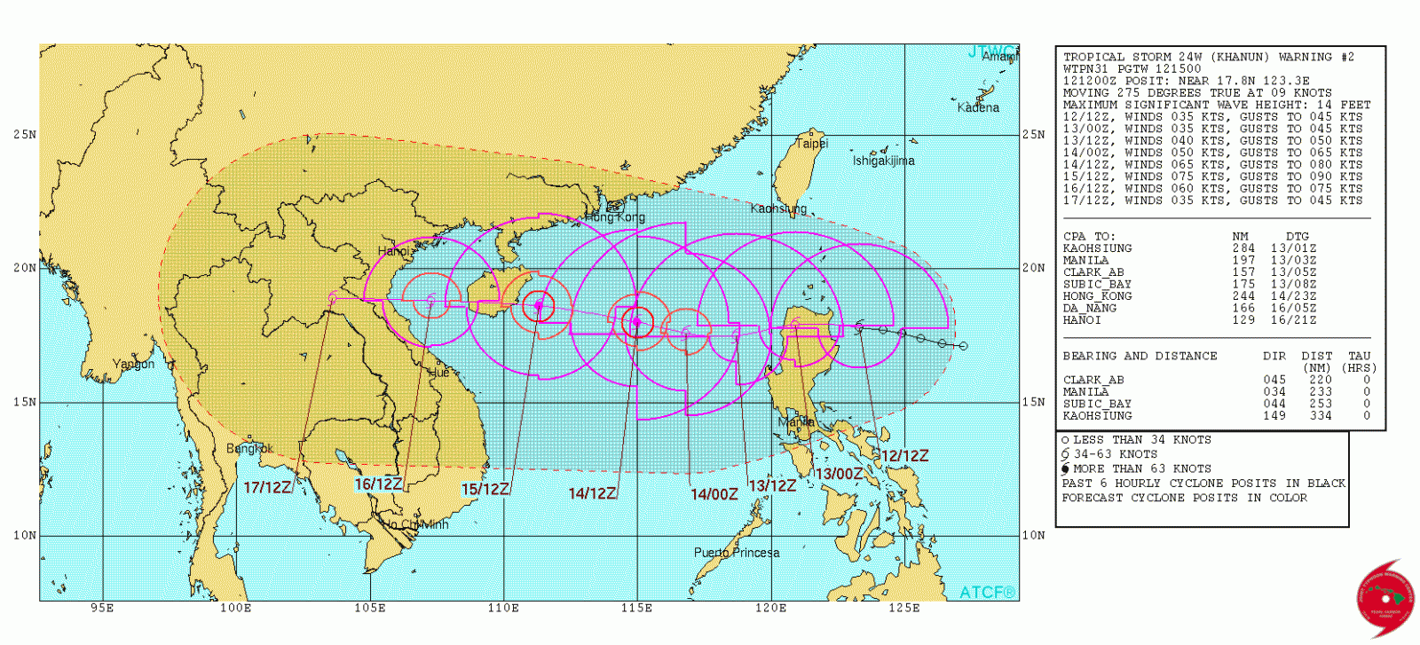
Tropical Storm "Khanun" by JTWC forecast track October 12, 2017
According to PAGASA, estimated rainfall amount is from moderate to heavy within 350 km (217 miles) from the center.
Khanun is expected to keep tracking westward as it remains on the southern periphery of the deep-layered subtropical ridge, JTWC noted.
The storm will maintain its intensity as it transits over Luzon and intensify upon entering the South China Sea. Over the next 24 hours, Khanun will increase to 74 km/h (46 mph) as it moves farther from Luzon and out over warm ocean water with sea surface temperatures of 29 – 30 °C (84.2 – 86 °F).
By 13:00 UTC on October 14, Khanun is expected to start moving WNW, reach a peak intensity of 140 km/h (87 mph) by 15:00 UTC on October 15 and make a landfall in southern Hainan just after that.
The system will make landfall again in northern Vietnam on October 16 (UTC) and weaken rapidly as it moves inland.

Teo Blašković founded The Watchers in 2011 and edited it until 2026, covering seismic and volcanic activity, extreme weather, space weather and near-Earth objects. Articles on this page are his archive.
Published in the last 24 hours
- Strong El Niño reinforces above-normal winter precipitation outlook across southern and eastern U.S.
- Scientists directly observe how submarine landslides unfold in western Canada Epicenter
- Odisha evacuated 983,642 people before Phailin crossed near Gopalpur on 12 October 2013 with winds of 200-210 km/h gusting to 220, and 44 died, against 9,885 in the 1999 super cyclone. Cyclone Akvan crossed the same coast on 20 November 2026. Epicenter
- Lava fountains reached 1,900 feet (580 m) at Kīlauea Iki in 1959, the highest ever recorded at Kīlauea, as USGS forecasts episode 57 fountaining at Halemaʻumaʻu for November 22-26. Epicenter
