
Extremely dangerous M7.1 earthquake hits Puebla, Mexico – more than 300 killed
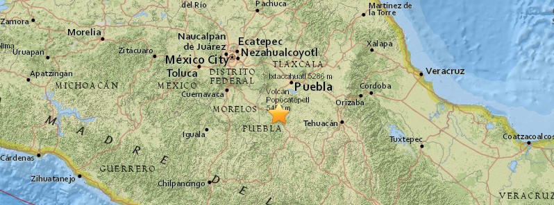
Image credit: USGS
A major earthquake registered by the USGS as M7.1 hit Puebla, Mexico at 18:14 UTC (13:14 local time) on September 19, 2017. The agency is reporting a depth of 51 km (31.7 miles). EMSC is reporting M7.1 at a depth of 30 km (18.6 miles).
This earthquake comes just 12 days after major M8.1 quake near the coast of Chiapas, Mexico and on the anniversary of the devastating 1985 M8.0 Michoacan earthquake, which caused extensive damage to Mexico City and the surrounding region. The 1985 earthquake caused between 5 000 and 45 000 deaths (found and missing). However, the most commonly cited figures are around 10 000.
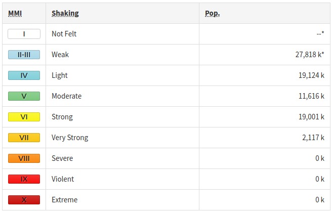
There are 8 500 000 people living within 100 km (62 miles). 77 000 are living within 10 km (6.2 miles).
Some 2 117 000 people are estimated to have felt very strong shaking, 19 001 000 felt strong shaking.
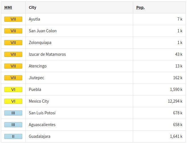
The epicenter was located 4.5 km (2.8 miles) NE of Raboso (population 4 374), 7.2 km (4.5 miles) ESE of Izúcar de Matamoros (population 42 936), 23.6 km (14.7 miles) ENE of Atencingo (population 12 910), 36.1 km (22.4 miles) S of Atlixco (population 85 891), and 55 km (34.1 miles) SSW of Puebla (population 1 590 256), Mexico.
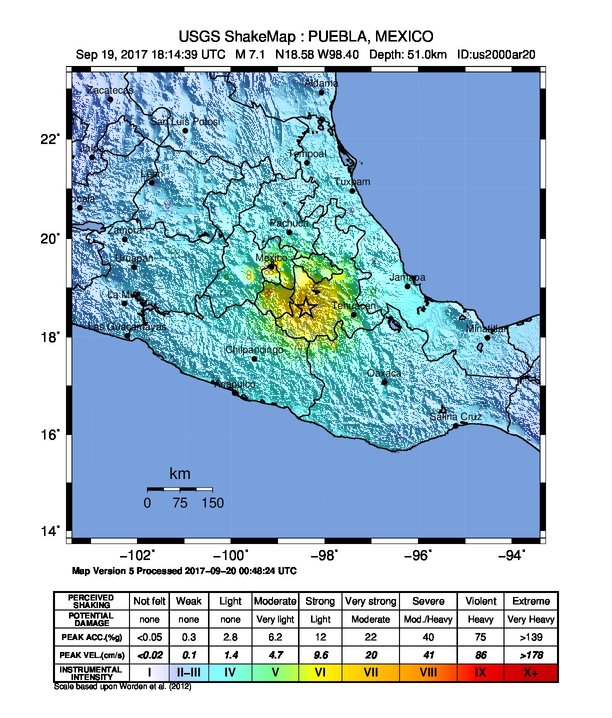
USGS issued an orange alert for shaking-related fatalities. Significant casualties are likely.
A red alert was issued for economic losses. Extensive damage is probable and the disaster is likely widespread. Estimated economic losses are less than 1% of GDP of Mexico. Past events with this alert level have required a national or international level response.
Overall, the population in this region resides in structures that are a mix of vulnerable and earthquake resistant construction. The predominant vulnerable building types are adobe block with concrete bond beam and mud wall construction.
Recent earthquakes in this area have caused secondary hazards such as tsunamis and landslides that might have contributed to losses.
Estimated population exposure to earthquake shaking
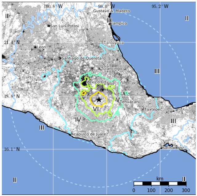
Selected cities exposed
Tectonic summary
The September 19, 2017, M7.1 earthquake in Central Mexico occurred as the result of normal faulting at a depth of approximately 50 km (31 miles). Focal mechanism solutions indicate that the earthquake occurred on a moderately dipping fault, striking either to the southeast or to the northwest. The event is near, but not directly on, the plate boundary between the Cocos and North America plates in the region.
At the location of this event, the Cocos plate converges with North America at a rate of approximately 76 mm/yr, in a northeast direction. The Cocos plate begins its subduction beneath Central America at the Middle America Trench, about 300 km (186 miles) to the southwest of this earthquake. The location, depth, and normal-faulting mechanism of this earthquake indicate that it is likely an intraplate event, within the subducting Cocos slab, rather than on the shallower megathrust plate boundary interface.
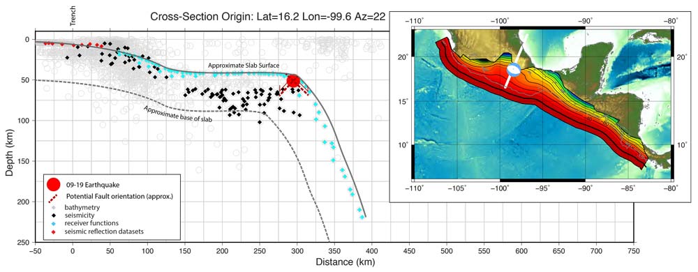
While commonly plotted as points on maps, earthquakes of this size are more appropriately described as slip over a larger fault area. Normal-faulting events of the size of the September 19th, 2017 earthquake are typically about 50×20 km / 31 x 12 miles (length x width).
Over the preceding century, the region within 250 km (155 miles) of the hypocenter of the September 19th, 2017 earthquake has experienced 19 other M6.5+ earthquakes. Most occurred near the subduction zone interface at the Pacific coast, to the south of the September 19 event. The largest was a M7.6 earthquake in July 1957, in the Guerrero region, which caused between to 50 – 160 fatalities, and many more injuries. In June 1999, a M7.0 at 70 km (43 miles) depth, just to the southeast of the September 19, 2017 earthquake, caused 14 fatalities, around 200 injuries, and considerable damage in the city of Puebla (MMI VIII).
September 19 was the anniversary of the devastating 1985 M8.0 Michoacan earthquake, which caused extensive damage to Mexico City and the surrounding region. That event occurred as the result of thrust faulting on the plate interface between the Cocos and North America plates, about 450 km (280 miles) to the west of the September 19, 2017 earthquake.
Today's earthquake also occurs 12 days after a M8.1 earthquake offshore of Chiapas, in southern Mexico. The epicenter of the M8.1 event is located about 650 km (404 miles) to the southeast of today's quake. That earthquake also occurred as the result of normal faulting within the subducting Cocos Plate, at a depth of 50 – 70 km (31 – 43 miles).
Updates
September 20
06:49 UTC
According to 2017 Earthquake Impact Database (source), the death toll now stands at 248 (Mexico City 117, Puebla 43, Morelos 72, Oaxaca 1, Guerrero 3). At least 731 people were injured and 45 buildings collapsed.
The death toll is expected to rise.
September 22
09:41 UTC
According to EID, the death toll has risen to 308 and the number of injured to 1 192.
Multimedia
Seismotectonics of Mexico
Located atop three of the large tectonic plates, Mexico is one of the world's most seismically active regions. The relative motion of these crustal plates causes frequent earthquakes and occasional volcanic eruptions. Most of the Mexican landmass is on the westward moving North American plate. The Pacific Ocean floor south of Mexico is being carried northeastward by the underlying Cocos plate. Because oceanic crust is relatively dense, when the Pacific Ocean floor encounters the lighter continental crust of the Mexican landmass, the ocean floor is subducted beneath the North American plate creating the deep Middle American trench along Mexico's southern coast. Also as a result of this convergence, the westward moving Mexico landmass is slowed and crumpled creating the mountain ranges of southern Mexico and earthquakes near Mexico's southern coast. As the oceanic crust is pulled downward, it melts; the molten material is then forced upward through weaknesses in the overlying continental crust. This process has created a region of volcanoes across south-central Mexico known as the Cordillera Neovolcánica.
The area west of the Gulf of California, including Mexico's Baja California Peninsula, is moving northwestward with the Pacific plate at about 50 mm per year. Here, the Pacific and North American plates grind past each other creating strike-slip faulting, the southern extension of California's San Andreas fault. In the past, this relative plate motion pulled Baja California away from the coast forming the Gulf of California and is the cause of earthquakes in the Gulf of California region today.
Mexico has a long history of destructive earthquakes and volcanic eruptions. In September 1985, a magnitude 8.1 earthquake killed more than 9,500 people in Mexico City. In southern Mexico, Volcán de Colima and El Chichón erupted in 2005 and 1982, respectively. Paricutín volcano, west of Mexico City, began venting smoke in a cornfield in 1943; a decade later this new volcano had grown to a height of 424 meters. Popocatépetl and Ixtaccíhuatl volcanos ("smoking mountain" and "white lady", respectively), southeast of Mexico City, occasionally vent gas that can be clearly seen from the City, a reminder that volcanic activity is ongoing. In 1994 and 2000 Popocatépetl renewed its activity forcing the evacuation of nearby towns, causing seismologists and government officials to be concerned about the effect a large-scale eruption might have on the heavily populated region. Popocatépetl volcano last erupted in 2010. (USGS) More information on regional seismicity and tectonics
I'm a dedicated researcher, journalist, and editor at The Watchers. With over 20 years of experience in the media industry, I specialize in hard science news, focusing on extreme weather, seismic and volcanic activity, space weather, and astronomy, including near-Earth objects and planetary defense strategies. You can reach me at teo /at/ watchers.news.
Séisme ouragan ces catastrophes naturelles des punitions d’ ALLAH pour éviter un tsunami en Mexique et en Amérique aux mexicains aux américains du Nord et du Sud de se convertir a l’islam le 21.9.2017 si la fin du monde 22.9.2017 pour éviter l’enfer l’augmentation des séismes en islam signe de la fin du monde.