
Hilary strengthens to Category 4 hurricane, significant and rare impacts expected in California and Nevada

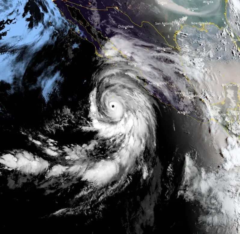
Featured image: Hurricane "Hilary" at 13:10 UTC on August 18, 2023. Image credit: NOAA/GOES-18, RAMMB/CIRA, The Watchers
Hilary rapidly strengthened into a Category 4 hurricane at 06:00 UTC on August 18, 2023, and continued moving WNW toward Baja California Peninsula, Mexico. Significant flooding impacts are possible across portions of the Baja California Peninsula and the southwestern United States.
- Heavy rainfall associated with Hilary may produce areas of flash flooding and result in landslides over portions of the Baja California Peninsula from late today into late Sunday, August 20. Rainfall impacts from Hilary within the Southwestern United States are expected to peak this weekend into Monday. Flash, urban, and arroyo flooding is expected with the potential for significant impacts.
- The threat of hurricane-force wind impacts is increasing along the west-central coast of the Baja California Peninsula, where a hurricane watch is in effect. Tropical storm conditions are expected to begin across the southern portion of the Baja California Peninsula later today and then spread northward through the weekend.
- The threat of significant wind impacts continues to increase for the northern portions of the Baja California Peninsula and the Southwestern United States, especially in areas of mountainous terrain. Although it is too soon to determine the location and magnitude of these impacts, interests in these areas should monitor the progress of Hilary and updates to the forecast. Watches could be issued for portions of this area, including along the southern California coast, later today.
- Large swells from Hilary will spread northward along the coast of southwestern Mexico and the Baja California Peninsula. These swells will reach the Gulf of California and northern portions of the Baja California Peninsula later this weekend.
A Hurricane Watch is in effect for the Baja California Peninsula north of Punta Abreojos to San Jose de Las Palmas. A Tropical Storm Warning is in effect for the Baja California Peninsula from Punta Abreojos southward and the Baja California Peninsula from Loreto southward. A Tropical Storm Watch is in effect for the Baja California Peninsula north of Loreto to Bahia de Los Angeles and mainland Mexico from Huatabampito to Bahia Kino.
At 12:00 UTC on August 18, the center of Hurricane “Hilary” was located about 165 km (100 miles) S of Socorro Island and about 640 km (400 miles) S of Cabo San Lucas, Mexico.
The system had maximum sustained winds of 230 km/h (145 mph) and a minimum central pressure of 942 hPa. It was moving WNW at 20 km/h (13 mph).
A turn toward the northwest and north-northwest is expected today and tonight, followed by a faster motion toward the north on Saturday night and Sunday (LT). On the forecast track, the center of Hilary will move close to the west coast of the Baja California Peninsula over the weekend and reach southern California by Sunday night, August 20.
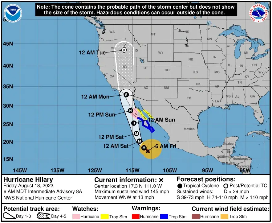
Fluctuations in intensity are likely over the next day or so. Weakening is expected to begin by Saturday, but Hilary will still be a hurricane when it approaches the west coast of the Baja California Peninsula Saturday night and Sunday.
The system is expected to weaken to a tropical storm by Sunday afternoon before it reaches southern California.
Hurricane-force winds extend outward up to 75 km (45 miles) from the center and tropical-storm-force winds extend outward up to 465 km (290 miles).
Hazards affecting land
Rainfall
Hilary is expected to produce rainfall amounts of 75 to 150 mm (3 to 6 inches), with isolated maximum amounts up to 250 mm (10 inches), across portions of the Baja California Peninsula through Sunday night. Flash flooding, locally significant, will be possible.
Heavy rainfall in association with Hilary is expected to impact the Southwestern United States through next Wednesday, August 23, peaking on Sunday and Monday. Rainfall amounts of 75 to 150 mm (3 to 6 inches), with isolated maximum amounts up to 250 mm (10 inches), are expected across portions of southern California and southern Nevada, which would lead to significant and rare impacts. Elsewhere across portions of the Western United States, rainfall totals of 25 to 75 mm (1 to 3 inches) are expected.
Wind
Hurricane conditions are possible within the hurricane watch area by Saturday night or Sunday morning, with tropical storm conditions possible by Saturday. Tropical storm conditions are expected within the warning area by late today (LT) and are possible within the watch area by early Saturday.
Storm surge
A storm surge could produce coastal flooding along the western Baja California Peninsula of Mexico near where the center passes the coast in areas of onshore winds, or east of the center if Hilary makes landfall. The surge will be accompanied by large and destructive waves.
Surf
Large swells generated by Hilary will affect portions of the coast of southwestern Mexico and the Baja California Peninsula over the next few days. These swells are likely to cause life-threatening surf and rip current conditions.
References:
1 Hurricane Hilary – Intermediate Advisory Number 8A – NWS National Hurricane Center Miami FL EP092023 – 600 AM MDT Fri Aug 18 2023
I'm a dedicated researcher, journalist, and editor at The Watchers. With over 20 years of experience in the media industry, I specialize in hard science news, focusing on extreme weather, seismic and volcanic activity, space weather, and astronomy, including near-Earth objects and planetary defense strategies. You can reach me at teo /at/ watchers.news.
Commenting rules and guidelines
We value the thoughts and opinions of our readers and welcome healthy discussions on our website. In order to maintain a respectful and positive community, we ask that all commenters follow these rules.