
Winter-like storm sets new records across Nevada
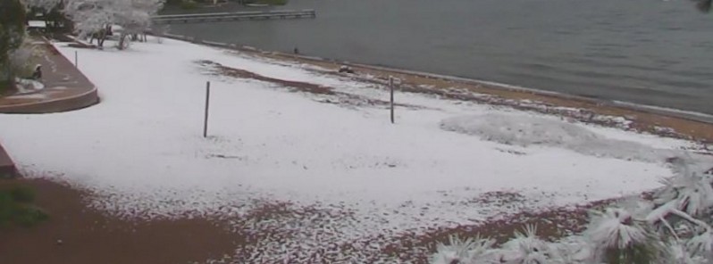
Featured image: Rare snow at Lake Tahoe, Nevada on June 12, 2017. Credit: NWS Reno, NV
An unusually strong and cold low pressure system caused several daily low temperatures and precipitation records to be set on Monday, June 12, 2017 across central and northern Nevada. On the same day, state's mountainous regions received an estimated 6 – 12 inches (152 – 305 mm) of snow.
A rare, winter-like storm hit parts of California and Nevada on July 11 and 12, 2017, bringing sharp temperatures drop, heavy rain, hail, frequent lightning, and even snow. Measurable snow was recorded at Lake Tahoe in the Sierra Nevada Mountains, on the border of California and Nevada. According to NWS Reno, this is something that happens in June about every 5 to 10 years.
Record daily low maximum temperatures were recorded at 3 locations:
- Elko Airport: New record is 45 °F (7.2 °C); Old record was 56 °F (13.3 °C) set in 1970
- Eureka Airport: New record is 52 °F (11.1 °C); Old record was 55 °F (12.8 °C) set in 2010
- Tonopah Airport: Tied with 62 °F (16.7 °C); Old record was 62 °F set in 1998
- Winnemucca Airport: New record is 50 °F (10 °C); Old record was 58 °F (14.4 °C) set in 1923
Record daily low temperature was measured at:
- Tonopah Airport with 34 °F (1.1 °C). The old record was 37 °F (2.8 °C) set in 1980.
Record daily precipitation was measured at 2 stations:
- Elko Airport: New record is 0.55 inches (14 mm); Old record was 0.30 inches (7.6 mm) set in 2016
- Winnemucca Airport: New record is 0.78 inches (19.8 mm); Old record was 0.36 inches (9.1 mm) set in 1885
Some measurable snow was reported for the first time at Elko and Ely airports.
On June 13, NWS Reno said a high pressure is building across the region resulting in a rapid warm-up in temperatures this week. "The temperatures may reach record levels by early next week," it said.
The name of our state means “snow-covered”! Estimated 6-12 inches of snow fell in NV Mountains Monday. #Nevada #nvwx pic.twitter.com/JMs0kdSAbi
— NWS Reno (@NWSReno) June 14, 2017
#snow in #Juneary for the Sierra! Yes, this is real. Measurable snow at #laketahoe in June happens about every 5-10 years. #summerwillreturn pic.twitter.com/0p89PUfSoc
— NWS Reno (@NWSReno) June 12, 2017
#Juneary #Snow in the Sierra! Dumping in Truckee right now at 5800'. More to come the next few hours. Drive safe this "summer" evening. pic.twitter.com/bUKxGNozRD
— NWS Reno (@NWSReno) June 12, 2017
High pressure building across the region resulting in a rapid warm-up in temps this week. Temps may reach record levels by early next week. pic.twitter.com/5dkt4Nz3ul
— NWS Reno (@NWSReno) June 13, 2017
Data source: NWS Elko, Nevada
The Watchers team and our contributors bring the latest on extreme weather, earthquakes, volcanic eruptions, space weather, and all things science. We're all about making sense of the natural world and keeping you informed on what’s happening. Got a tip or a question? Hit us up using the form at newstips!
Commenting rules and guidelines
We value the thoughts and opinions of our readers and welcome healthy discussions on our website. In order to maintain a respectful and positive community, we ask that all commenters follow these rules.