
Stormy Christmas in store for UK, as Storm “Barbara” approaches
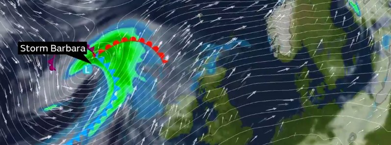
Image credit: UK Met Office
A spell of stormy weather is expected to affect the UK, starting on December 23, 2016, as an intense low pressure system is currently brewing in the west Atlantic. Storm "Barbara" will bring heavy rainfall and strong winds across the UK, especially in the north and west of Scotland.
A storm named Barbara, by the UK Met Office, will be the second named storm of the 2016/17 season. The National Severe Weather Warnings are already in place in the north and west of the UK while other regions will also experience windy weather.
The cold Arctic air sinking southward has already brought cold weather conditions to portions of the North America. As the cold air mass encounters the warmer air in the western Atlantic, a strong temperature gradient is created along the boundary separating the two air masses. These conditions contribute to the strengthening of the jet stream which then comes east across the Atlantic, driving regions of low air pressure toward the UK.
"Storm Barbara is now forming in the west Atlantic and will pass close to the northwest of the UK during Friday, bringing very strong winds and heavy rain, especially across the north and west of Scotland. This brings the potential for some structural damage, disruption to power supplies and travel, with restrictions on bridges and disruption to ferries likely," explained Chris Tubbs, Deputy Chief Meteorologist at UK Met Office.
"The disturbed conditions look like continuing through the Christmas weekend with another vigorous low pressure system waiting in the wings. So, whatever your plans over the next few days it's worthwhile staying up to date with the latest Met Office forecasts, which is easy to do on our app," he added.
A Yellow wind warning is currently in place in the north and northwest Scotland while the rainfall is also expected across parts of the southern England.
Video credit: UK Met Office
#StormBarbara affecting the UK on Friday. Some travel disruption likely. Keep up to date with the latest information on our website and app pic.twitter.com/1zHbB4XUp5
— Met Office (@metoffice) December 20, 2016
An Amber wind warning has been put in effect for northern and western parts of Scotland for December 23 until December 25. South and southwesterly winds are expected across the entire country while wind gusts between 96.6 and 112.6 km/h (60 and 70 mph) are most likely to affect regions under the warning. Westerly gusts between 128.7 and 144.8 km/h (80 and 90 mph) are expected in portions of western and northern Scotland on the evening of December 23 into December 24 (local time). These winds will ease down by the morning of December 24.
The storm will likely cause disruptions to traffic and power supplies while some infrastructural damage may also occur.
“Our National Traffic Control Centre will be operational across the period with our Multi Agency Response Team active on the days leading up to Christmas. Ferries are particularly susceptible to disruption due to high winds and we may also see some disruption to flights. Those planning to fly or use ferries should check with their operators for the latest information and consider the forecast as part of their plans,” said Humza Yousaf, Scotland Transport Minister.
A Yellow wind warning is also in place for December 25, for regions of Scotland, Northern Ireland, and northern England where the wind gusts between 80.5 and 96.6 km/h (50 and 60 mph) are expected. Parts of northern Scotland are likely to see winds between 96.6 and 112.6 km/h (60 and 70 mph) while some places in the far Northern Islands may even experience gusts exceeding 128.7 km/h (80 mph). Large waves are in store for the coastal areas.
“The weather is taking a decided turn for the worse as we near Christmas itself, and drivers are going to need to be on their guard. Heavy downpours and extremely gusty winds will join forces to make the going tough for anyone driving on Friday especially. Early indications are that more storms could also roll in in the days to come. Anyone wanting to avoid the worst conditions on the roads should look for the calmer weather windows – right now, Thursday and the afternoon of Christmas Eve look better, but we urge drivers to keep a close eye on the forecast and plan any longer trips carefully,” said Rod Dennis, a spokesman for the RAC Traffic Watch.
Commenting rules and guidelines
We value the thoughts and opinions of our readers and welcome healthy discussions on our website. In order to maintain a respectful and positive community, we ask that all commenters follow these rules.