
Massive M7.8 earthquake hits Solomon Islands, tsunami waves forecast
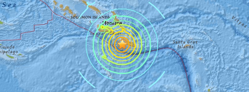
Image credit: USGS
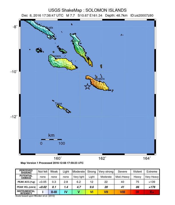
A powerful earthquake registered by the USGS as M7.8 hit near the coast of Solomon Islands at 17:38 UTC (04:38 local time) on December 8, 2016. The agency is reporting a depth of 41 km (25.4 miles). Geoscience Australia is reporting M8.1 at a depth of 35 km (21.7 miles). USGS initially reported M8.0.
The epicenter was located 68.2 km (42.4 miles) WSW of Kirakira (population 1 122) and 203.9 km (126.7 miles) SE of Honiara (population 56 298), Solomon Islands.
There are about 33 822 people living within 100 km (62 miles).
Based on the preliminary earthquake parameters, widespread hazardous tsunami waves are possible, PTWC said.
Hazardous tsunami waves are possible within the next three hours along some coasts of Solomon Islands, Vanuatu, Papua New Guinea, Nauru, New Caledonia, Tuvalu and Kosrae.
Updated PTWC threat message (18:54 UTC)
EVALUATION
----------

  * AN EARTHQUAKE WITH A PRELIMINARY MAGNITUDE OF 7.8 OCCURRED IN
    THE SOLOMON ISLANDS AT 1739 UTC ON THURSDAY DECEMBER 8 2016.

  * BASED ON ALL AVAILABLE DATA... HAZARDOUS TSUNAMI WAVES ARE
    FORECAST FOR SOME COASTS.


TSUNAMI THREAT FORECAST...UPDATED
---------------------------------

  * TSUNAMI WAVES REACHING 1 TO 3 METERS ABOVE THE TIDE LEVEL ARE
    POSSIBLE ALONG SOME COASTS OF

      SOLOMON ISLANDS.


  * TSUNAMI WAVES REACHING 0.3 TO 1 METERS ABOVE THE TIDE LEVEL
    ARE POSSIBLE FOR SOME COASTS OF

      PAPUA NEW GUINEA.

  * TSUNAMI WAVES ARE FORECAST TO BE LESS THAN 0.3 METERS ABOVE
    THE TIDE LEVEL FOR THE COASTS OF

      FRENCH POLYNESIA.

  * FOR OTHER AREAS TSUNAMI WAVES ARE FORECAST TO BE MUCH LESS
    THAN 0.3 METERS ABOVE THE TIDE LEVEL.

  * ACTUAL AMPLITUDES AT THE COAST MAY VARY FROM FORECAST
    AMPLITUDES DUE TO UNCERTAINTIES IN THE FORECAST AND LOCAL
    FEATURES. IN PARTICULAR MAXIMUM TSUNAMI AMPLITUDES ON ATOLLS
    AND AT LOCATIONS WITH FRINGING OR BARRIER REEFS WILL LIKELY
    BE MUCH SMALLER THAN THE FORECAST INDICATES.

  * FOR OTHER AREAS COVERED BY THIS PRODUCT A FORECAST HAS NOT
    YET BEEN COMPUTED. THE FORECAST WILL BE EXPANDED IF
    NECESSARY IN SUBSEQUENT PRODUCTS.

RECOMMENDED ACTIONS
-------------------

  * GOVERNMENT AGENCIES RESPONSIBLE FOR THREATENED COASTAL AREAS
    SHOULD TAKE ACTION TO INFORM AND INSTRUCT ANY COASTAL
    POPULATIONS AT RISK IN ACCORDANCE WITH THEIR OWN
    EVALUATION... PROCEDURES AND THE LEVEL OF THREAT.

  * PERSONS LOCATED IN THREATENED COASTAL AREAS SHOULD STAY ALERT
    FOR INFORMATION AND FOLLOW INSTRUCTIONS FROM NATIONAL AND
    LOCAL AUTHORITIES.

ESTIMATED TIMES OF ARRIVAL
--------------------------

  * ESTIMATED TIMES OF ARRIVAL -ETA- OF THE INITIAL TSUNAMI WAVE
    FOR PLACES WITHIN THREATENED REGIONS ARE GIVEN BELOW. ACTUAL
    ARRIVAL TIMES MAY DIFFER AND THE INITIAL WAVE MAY NOT BE THE
    LARGEST. A TSUNAMI IS A SERIES OF WAVES AND THE TIME BETWEEN
    WAVES CAN BE FIVE MINUTES TO ONE HOUR.

    LOCATION         REGION             COORDINATES    ETA(UTC)
    ------------------------------------------------------------
    KIRAKIRA         SOLOMON ISLANDS   10.4S 161.9E   1808 12/08
    AUKI             SOLOMON ISLANDS    8.8S 160.6E   1813 12/08
    HONIARA          SOLOMON ISLANDS    9.3S 160.0E   1820 12/08
    MUNDA            SOLOMON ISLANDS    8.4S 157.2E   1831 12/08
    GHATERE          SOLOMON ISLANDS    7.8S 159.2E   1843 12/08
    PANGGOE          SOLOMON ISLANDS    6.9S 157.2E   1903 12/08
    WOODLARK ISLAND  PAPUA NEW GUINEA   9.0S 152.9E   1904 12/08

POTENTIAL IMPACTS
-----------------

  * A TSUNAMI IS A SERIES OF WAVES. THE TIME BETWEEN WAVE CRESTS
    CAN VARY FROM 5 MINUTES TO AN HOUR. THE HAZARD MAY PERSIST
    FOR MANY HOURS OR LONGER AFTER THE INITIAL WAVE.

  * IMPACTS CAN VARY SIGNIFICANTLY FROM ONE SECTION OF COAST TO
    THE NEXT DUE TO LOCAL BATHYMETRY AND THE SHAPE AND ELEVATION
    OF THE SHORELINE.

  * IMPACTS CAN ALSO VARY DEPENDING UPON THE STATE OF THE TIDE AT
    THE TIME OF THE MAXIMUM TSUNAMI WAVES.

  * PERSONS CAUGHT IN THE WATER OF A TSUNAMI MAY DROWN... BE
    CRUSHED BY DEBRIS IN THE WATER... OR BE SWEPT OUT TO SEA.
The maximum estimated tsunami wave height is 1.5 m (4.9 feet) at 18:27 UTC in Oneoia, Solomon Islands, according to the JRC.
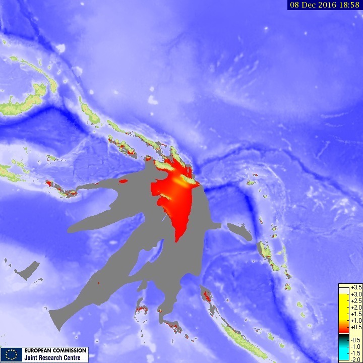
Credit: JRC
A Tsunami Watch was briefly in effect for Hawaii.
Professor Max Wyss, who specializes in theoretical prognoses of injuries and fatalities expects 0 to 50 fatalities and 30 to 270 injured, ER reported. This is quite a lot for the Solomon Islands.
USGS issued a green alert for shaking-related fatalities and economic losses. There is a low likelihood of casualties and damage.
Overall, the population in this region resides in structures that are vulnerable to earthquake shaking, though some resistant structures exist. The predominant vulnerable building types are mud wall and informal (metal, timber, GI etc.) construction.
Recent earthquakes in this area have caused secondary hazards such as tsunamis that might have contributed to losses.
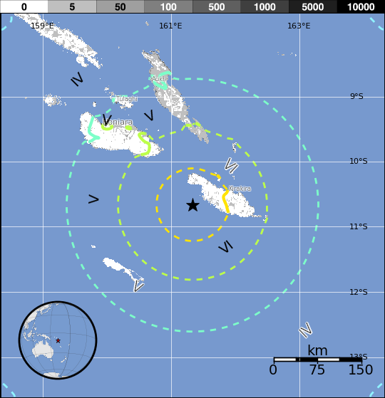
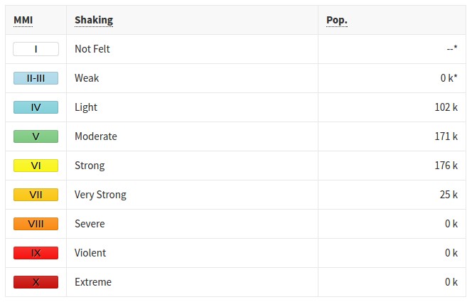
Estimated population exposure to earthquake shaking
Updates
December 9, 2016 @ 12:30 UTC
Tsunami warnings have been lifted off.
There are reports of collapsed buildings and landslides it the most affected Makira-Ulawa province. The police said 35 to 40 houses on the island of Makira were damaged, including the police barracks at the provincial capital Kirakira. About 3 000 people have been affected.
Read more: Damage assessment after M7.8 earthquake in Solomon Islands
19:43 UTC
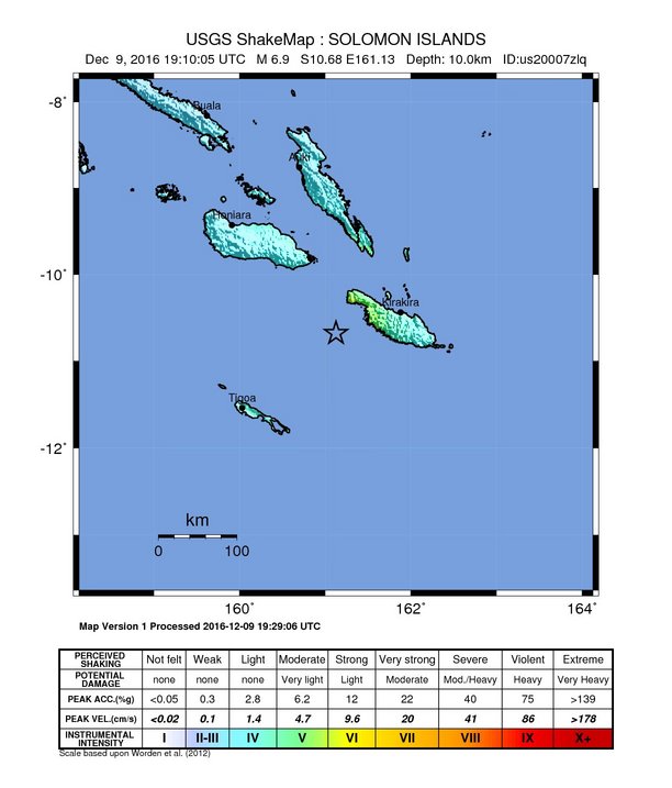
A powerful aftershock measuring M6.9 hit the region at 19:10 UTC at a depth of 10 km (6.2 miles).
This quake was not sufficient to generate a tsunami, PTWC said.
Seismotectonics of the eastern margin of the Australia Plate
The eastern margin of the Australia plate is one of the most seismically active areas of the world due to high rates of convergence between the Australia and Pacific plates. In the region of New Zealand, the 3000 km long Australia-Pacific plate boundary extends from south of Macquarie Island to the southern Kermadec Island chain. It includes an oceanic transform (the Macquarie Ridge), two oppositely verging subduction zones (Puysegur and Hikurangi), and a transpressive continental transform, the Alpine Fault through South Island, New Zealand.
Since 1900 there have been 15 M7.5+ earthquakes recorded near New Zealand. Nine of these, and the four largest, occurred along or near the Macquarie Ridge, including the 1989 M8.2 event on the ridge itself, and the 2004 M8.1 event 200 km to the west of the plate boundary, reflecting intraplate deformation. The largest recorded earthquake in New Zealand itself was the 1931 M7.8 Hawke's Bay earthquake, which killed 256 people. The last M7.5+ earthquake along the Alpine Fault was 170 years ago; studies of the faults' strain accumulation suggest that similar events are likely to occur again.
North of New Zealand, the Australia-Pacific boundary stretches east of Tonga and Fiji to 250 km south of Samoa. For 2,200 km the trench is approximately linear, and includes two segments where old (>120 Myr) Pacific oceanic lithosphere rapidly subducts westward (Kermadec and Tonga). At the northern end of the Tonga trench, the boundary curves sharply westward and changes along a 700 km-long segment from trench-normal subduction, to oblique subduction, to a left lateral transform-like structure.
Australia-Pacific convergence rates increase northward from 60 mm/yr at the southern Kermadec trench to 90 mm/yr at the northern Tonga trench; however, significant back arc extension (or equivalently, slab rollback) causes the consumption rate of subducting Pacific lithosphere to be much faster. The spreading rate in the Havre trough, west of the Kermadec trench, increases northward from 8 to 20 mm/yr. The southern tip of this spreading center is propagating into the North Island of New Zealand, rifting it apart. In the southern Lau Basin, west of the Tonga trench, the spreading rate increases northward from 60 to 90 mm/yr, and in the northern Lau Basin, multiple spreading centers result in an extension rate as high as 160 mm/yr. The overall subduction velocity of the Pacific plate is the vector sum of Australia-Pacific velocity and back arc spreading velocity: thus it increases northward along the Kermadec trench from 70 to 100 mm/yr, and along the Tonga trench from 150 to 240 mm/yr.
The Kermadec-Tonga subduction zone generates many large earthquakes on the interface between the descending Pacific and overriding Australia plates, within the two plates themselves and, less frequently, near the outer rise of the Pacific plate east of the trench. Since 1900, 40 M7.5+ earthquakes have been recorded, mostly north of 30°S. However, it is unclear whether any of the few historic M8+ events that have occurred close to the plate boundary were underthrusting events on the plate interface, or were intraplate earthquakes. On September 29, 2009, one of the largest normal fault (outer rise) earthquakes ever recorded (M8.1) occurred south of Samoa, 40 km east of the Tonga trench, generating a tsunami that killed at least 180 people.
Across the North Fiji Basin and to the west of the Vanuatu Islands, the Australia plate again subducts eastwards beneath the Pacific, at the North New Hebrides trench. At the southern end of this trench, east of the Loyalty Islands, the plate boundary curves east into an oceanic transform-like structure analogous to the one north of Tonga.
Australia-Pacific convergence rates increase northward from 80 to 90 mm/yr along the North New Hebrides trench, but the Australia plate consumption rate is increased by extension in the back arc and in the North Fiji Basin. Back arc spreading occurs at a rate of 50 mm/yr along most of the subduction zone, except near ~15°S, where the D'Entrecasteaux ridge intersects the trench and causes localized compression of 50 mm/yr in the back arc. Therefore, the Australia plate subduction velocity ranges from 120 mm/yr at the southern end of the North New Hebrides trench, to 40 mm/yr at the D'Entrecasteaux ridge-trench intersection, to 170 mm/yr at the northern end of the trench.
Large earthquakes are common along the North New Hebrides trench and have mechanisms associated with subduction tectonics, though occasional strike slip earthquakes occur near the subduction of the D'Entrecasteaux ridge. Within the subduction zone 34 M7.5+ earthquakes have been recorded since 1900. On October 7, 2009, a large interplate thrust fault earthquake (M7.6) in the northern North New Hebrides subduction zone was followed 15 minutes later by an even larger interplate event (M7.8) 60 km to the north. It is likely that the first event triggered the second of the so-called earthquake "doublet". More information on regional seismicity and tectonics
The Watchers team and our contributors bring the latest on extreme weather, earthquakes, volcanic eruptions, space weather, and all things science. We're all about making sense of the natural world and keeping you informed on what’s happening. Got a tip or a question? Hit us up using the form at newstips!
there is gona be a big bang soon