
Hermine became a hurricane before Florida landfall, life-threatening surge, tornadoes and flooding expected
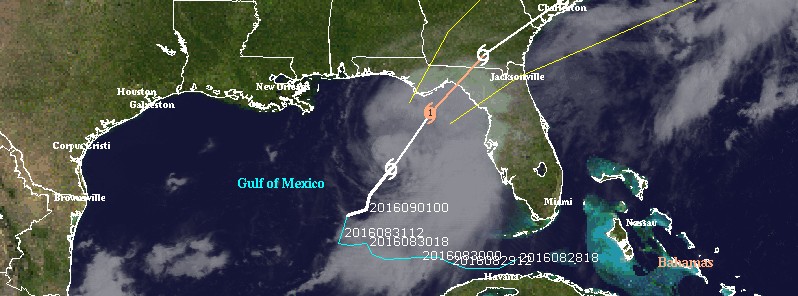
Image credit: Tropical Storm "Hermine" at 13:45 UTC on September 1, 2016
Tropical Storm "Hermine" officially became a hurricane at 18:00 UTC on September 1, 2016, just hours before Florida landfall. This will be Florida's first hurricane landfall in almost 11 years. Life-threatening surge, tornadoes, and flooding rains are expected.
Outer bands of Tropical Storm "Hermine" came ashore last night in SW Florida bringing extremely heavy rain that quickly flooded even major roads.
Video courtesy StormChasingVideos. Via Stormwall
At 15:00 UTC on September 1, 2016, Hermine's was located about 350 km (220 miles) west of Tampa and 275 km (170 miles) south-southwest of Apalachicola, Florida. The system is moving north-northeast at 22 km/h (14 mph), bringing very heavy rain. At the time, Hermine's maximum sustained winds were near 100 km/h (65 mph) with higher gusts. Hermine's NNE motion with a slight increase in forward speed is expected during the next day or so. Its minimum central pressure is currently 991 hPa.
Hermine officially became a hurricane at 18:00 UTC. Its center is expected to be near the Florida coast in the hurricane warning area tonight or early Friday, September 2, 2016 (local time).
Tropical-storm-force winds extend outward up to 220 km (140 miles) from the center.
As of 15:00 UTC today (10:00 CDT), a Hurricane Warning is in effect for Suwannee River to Mexico Beach. A Hurricane Watch is in effect for Anclote River to Suwannee River and west of Mexico Beach to the Walton/Bay County line. A Tropical Storm Warning is in effect for Anclote River to Suwannee River, west of Mexico Beach to the Walton/Bay County line, and Marineland to Surf City. A Tropical Storm Watch is in effect for north of Surf City to Oregon Inlet, including Pamlico Sound.
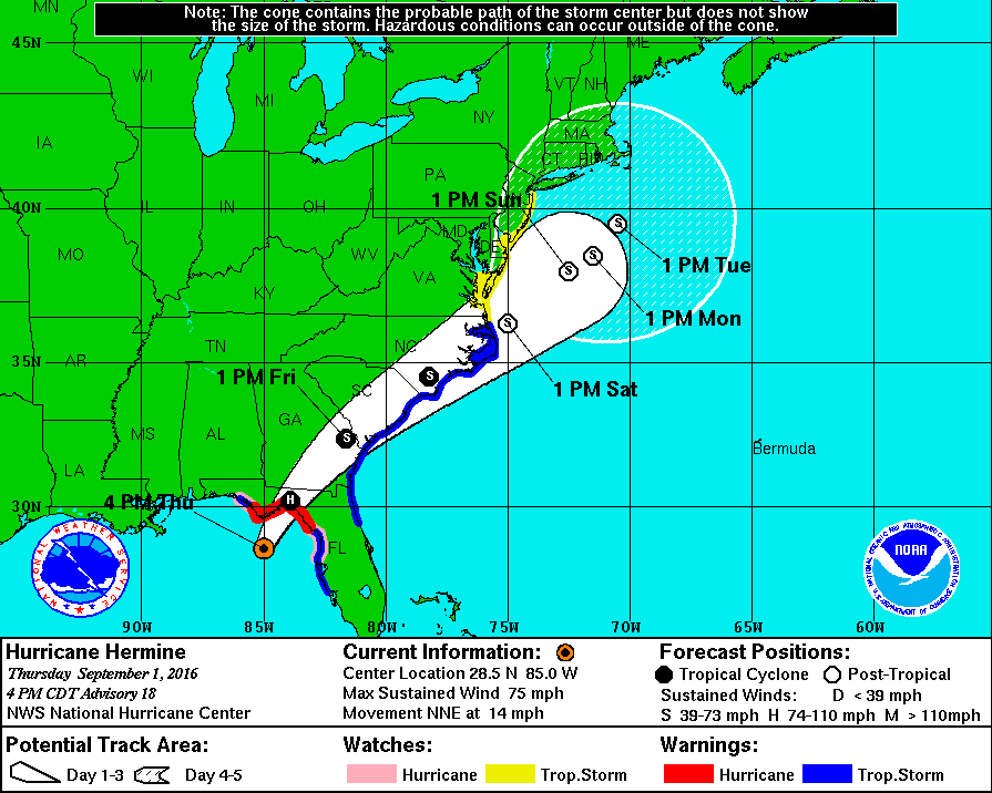
Hurricane "Hermine" forecast track by NWS/NHC on September 1, 2016
Hurricane conditions are expected to reach the coast within the warning area beginning tonight (local time). Winds are expected to first reach tropical storm strength by this afternoon, making outside preparations difficult or dangerous. Preparations to protect life and property should be rushed to completion. Tropical storm conditions are expected to begin within the warning area along the Atlantic coast on Friday, and spread northward through Friday evening. Tropical storm conditions are possible in the tropical storm watch area by Friday night and Saturday.
The combination of a dangerous storm surge and the tide will cause normally dry areas near the coast to be flooded by rising waters moving inland from the shoreline. There is a danger of life-threatening inundation within the next 12 to 24 hours along the Gulf coast of Florida from Aripeka to Indian Pass. For a depiction of areas at risk, please see the Prototype National Weather Service Storm Surge Watch/Warning Graphic. Persons located within these areas should take all necessary actions to protect life and property from rising water.
The water could reach the following heights above ground if the peak surge occurs at the time of high tide:
Destin to Indian Pass: 30.5 to 91.5 cm (1 to 3 feet)
Indian Pass to Ochlockonee River: 122 to 213 cm (4 to 7 feet)
Ochlockonee River to Keaton Beach: 152 to 244 cm (5 to 8 feet)
Keaton Beach to Chassahowitzka: 122 to 213 cm (4 to 7 feet)
Chassahowitzka to Aripeka: 61 to 122 cm (2 to 4 feet)
Aripeka to Bonita Beach…including Tampa Bay: 30.5 to 91.5 cm (1 to 3 feet)
Florida-Georgia line to Cape Fear: 30.5 to 91.5 cm (1 to 3 feet)
Below is a 3D flyby of Tropical Storm "Hermine" created using radar data from the GPM core satellite. On August 31 at 20:00 UTC (16:00 EDT) GPM found rainfall occurring at a rate of over 251 mm (9.9 inches) per hour in very powerful storms southwest of Hermine's center of circulation. Cloud tops were reaching heights above 16 km (9.9 miles).
Credit: NASA/JAXA, Hal Pierce
Hermine is expected to produce storm total rainfall accumulations of 127 to 254 (5 to 10 inches) over portions of northwest Florida and southern Georgia through Friday, with possible isolated maximum amounts of 508 mm (20 inches).
On Friday and Saturday, Hermine is expected to produce totals of 101.6 to 203.2 mm (4 to 8 inches) with isolated maximum amounts of 254 mm (10 inches) possible across portions of eastern Georgia, South Carolina, and eastern North Carolina through Saturday. These rains may cause life-threatening flash flooding.
A few tornadoes are possible this afternoon into Friday morning over north Florida and southeast Georgia. The tornado risk will continue across the eastern Carolinas from Friday morning into Friday night.
The last hurricane to make landfall in Florida was Wilma on October 24, 2005. The most recent September hurricane landfall in Florida was Jeanne in 2004.
It has been 3965 days since the last hurricane make landfall in Florida (Wilma on October 24, 2005). #Hermine pic.twitter.com/gPrItOZttM
— Philip Klotzbach (@philklotzbach) September 1, 2016
The Watchers team and our contributors bring the latest on extreme weather, earthquakes, volcanic eruptions, space weather, and all things science. We're all about making sense of the natural world and keeping you informed on what’s happening. Got a tip or a question? Hit us up using the form at newstips!
Commenting rules and guidelines
We value the thoughts and opinions of our readers and welcome healthy discussions on our website. In order to maintain a respectful and positive community, we ask that all commenters follow these rules.