
Severe weather outbreak from US Midwest to Mid-Atlantic, powerful storms sweep through Illinois

Image credit: Power flashes were reported at Pontiac, Illinois late June 22 (local time).
A severe weather outbreak is currently in progress from the US Midwest to the Mid-Atlantic. After ripping through Illinois on June 22 and 23, strong storms will continue impacting portions of the Midwest and Ohio River Valley before quickly spreading towards the Mid-Atlantic. On Thursday, June 23, the primary threat with these storms will be damaging winds, but large hail and even an isolated tornado cannot be ruled out.
Two rounds of storms have hit the US Midwest on Wednesday, June 22, 2016, bringing strong winds, large hail, and tornadoes. Hail the size of golf balls was reported in North Dakoda before the storms moved into Chicago area, canceling 140 flights around 12:00 CTD. By the end of the day, more than 400 flights were canceled.
Overview for June 22, 2016, and June 23 forecast
Storm chaser Scott Peake was driving near a tornado in the town of Earlville, Illinois when the twister whipped some debris back into his windshield, CBS Chicago reports. The event was captured on one of his cameras:
Scott Peake speaking to CBS Chicago
Around 01:30 UTC on June 23 (20:30 CDT, June 22), a large cone tornado moved into the town of Pontiac, Illinois. Power flashes were reported before much of the town lost power. Storm chasers reported mobile homes destroyed at a trailer park. The Weather Channel said it is unknown, at this time, if there were any injuries, but people were reportedly trapped. Fire officials reported a gas station canopy fell onto a semi truck near Interstate 55.

Frequent power flashes, Pontiac, IL – June 2016.
There were unconfirmed tornadoes near the Illinois towns of La Moille, Manlius, Leland, Troy Grove and Sheridan.
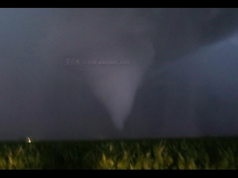
Video credit Dan Robinson
Forecast
Strong storms will continue impacting portions of the Midwest and Ohio River Valley before quickly spreading towards the Mid-Atlantic on Thursday, June 23. The primary threat with these storms will be damaging winds, but large hail and even an isolated tornado cannot be ruled out, NWS said.

Convective outlook valid: 12:00 UTC on June 22 – 12:00 UTC on June 23. Credit: NWS

Convective outlook valid 12:00 UTC on June 23 – 12:00 UTC on June 24. Credit: NWS
Scattered storms capable of damaging winds, large hail and tornadoes are expected. Particularly across the Mid-Ohio Valley and into West Virginia.
The risk for isolated hail and locally damaging wins is also apparent over portions of the Eastern Colorado vicinity. A more isolated risk for hail and locally damaging wind gusts are possible over the remainder of the High Plains, from Eastern Montana to Eastern New Mexico, and eastward across Kansas and into the Ozarks.

The Watchers team and our contributors bring the latest on extreme weather, earthquakes, volcanic eruptions, space weather, and all things science. We're all about making sense of the natural world and keeping you informed on what’s happening. Got a tip or a question? Hit us up using the form at newstips!
Earlier reporting
Nothing on Watchers was published in the last 24 hours. These are older articles.
- 2 atmospheric rivers to bring heavy Sierra snow and California flood risk
- CPC posts a slight risk of heavy rain from the Gulf Coast to the Northeast urban corridor November 25-29, and a moderate risk of West Coast wind and Sierra snow on November 25
- The storms drenching California this week are fed by a river in the sky, a band of water vapor that can carry up to 15 times the flow of the Mississippi River, and this winter’s near-record El Niño could keep aiming more of them at the West Coast
- Atmospheric river brings moderate risk of heavy rain, mountain snow and high winds to northern California and southwest Oregon on November 24-25
