
Eruption of Nevado del Ruiz volcano sends ash up to 9.1 km a.s.l., Colombia
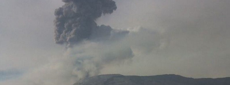
Featured image: Nevado del Ruiz erupting on March 31, 2016. Credit: SGC
A moderately strong explosion occurred at Nevado del Ruiz volcano, Colombia at around 13:04 UTC on March 31, 2016.
According to Washington VAAC, volcanic ash emission is reaching 9.1 km (30 000 feet) a.s.l. and is moving NW at 9 to 18 km/h (5.7 to 11.5 mph) and SW at 46.3 km/h to 55.5 km/h (28.7 to 34.5 mph). This is 3.8 km (12 685 feet) above the summit.
Volcanic ash moving to the NW is expected to dissipate within 6+ hours. Volcanic ash moving to the SW is expected to dissipate within 12+ hours.
A strong pulse in tremor accompanied the eruption which likely caused ash fall in nearby areas, Volcano Discovery said.
De esta manera se observó, a las 7am, la emisión de ceniza del #NevadodelRuiz desde #AnzoáteguiTol @cruzrojacol pic.twitter.com/xE7lSGjcNJ
— Alejandro Zuluaga (@alejzuluaga) March 31, 2016
Observatorio Vulcanológico y Sismológico de Manizales reported that a number of similar, but weaker tremor pulses were recorded at the volcano recently. When the summit of the volcano was not in clouds, it could be observed that at least some of them were also signs of small to moderate ash emissions.
Based on an ASHTAM (a special Notice to Airmen for airborne ash), the Washington VAAC reported a possible emission from Nevado del Ruiz on March 28. Ash was not identified in satellite images although a thermal anomaly was detected. A period of increased seismicity was detected the next day, and observers reported another possible ash emission.
Manizales observatory reported that an episode of volcanic tremor was associated with an ash emission that rose 1.7 km (5 577 feet) above the volcano on March 18. This is 6.9 km (22 892 feet) a.s.l.
Geological summary
Nevado del Ruiz is a broad, glacier-covered volcano in central Colombia that covers >200 sq km. Three major edifices, composed of andesitic and dacitic lavas and andesitic pyroclastics, have been constructed since the beginning of the Pleistocene. The modern cone consists of a broad cluster of lava domes built within the caldera of an older edifice. The 1-km-wide, 240-m-deep Arenas crater occupies the summit.
The prominent La Olleta pyroclastic cone located on the SW flank may also have been active in historical time. Steep headwalls of massive landslides cut the flanks. Melting of its summit icecap during historical eruptions, which date back to the 16th century, has resulted in devastating lahars, including one in 1985 that was South America's deadliest eruption. (GVP)
I'm a dedicated researcher, journalist, and editor at The Watchers. With over 20 years of experience in the media industry, I specialize in hard science news, focusing on extreme weather, seismic and volcanic activity, space weather, and astronomy, including near-Earth objects and planetary defense strategies. You can reach me at teo /at/ watchers.news.
hey buddy