
Joaquin lashes the Bahamas, historic flooding expected across southeast US
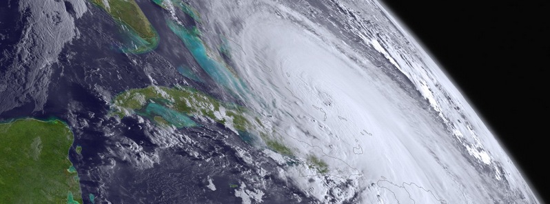
Featured image: Hurricane "Joaquin" on October 1, 2015. Credit: NOAA GOES/West
Major Hurricane "Joaquin" has weakened slightly as its eye passed near San Salvador island, and is now a category 3 hurricane, National Hurricane Center (NHC) reported. Although newest modeling results suggest the system most likely won't make landfall over the US, its moisture has combined with persistent slow moving front lurking over mainland, and will induce life-threatening floods across the southeast US coast. Emergency status has been declared for low lying coastal and inland areas, from Carolinas to Virginia, as citizens are warned to stay alert.
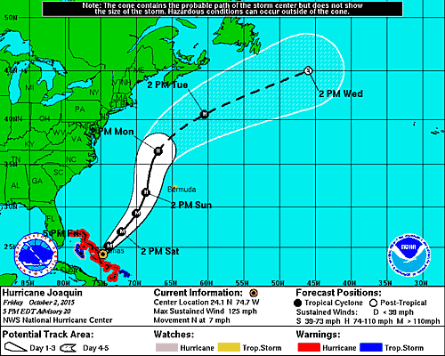
The system was located about 25 km (15 miles) west northwest of San Salvador and about 1 330 km (825 miles) from Bermuda on October 2, 21:00 UTC.
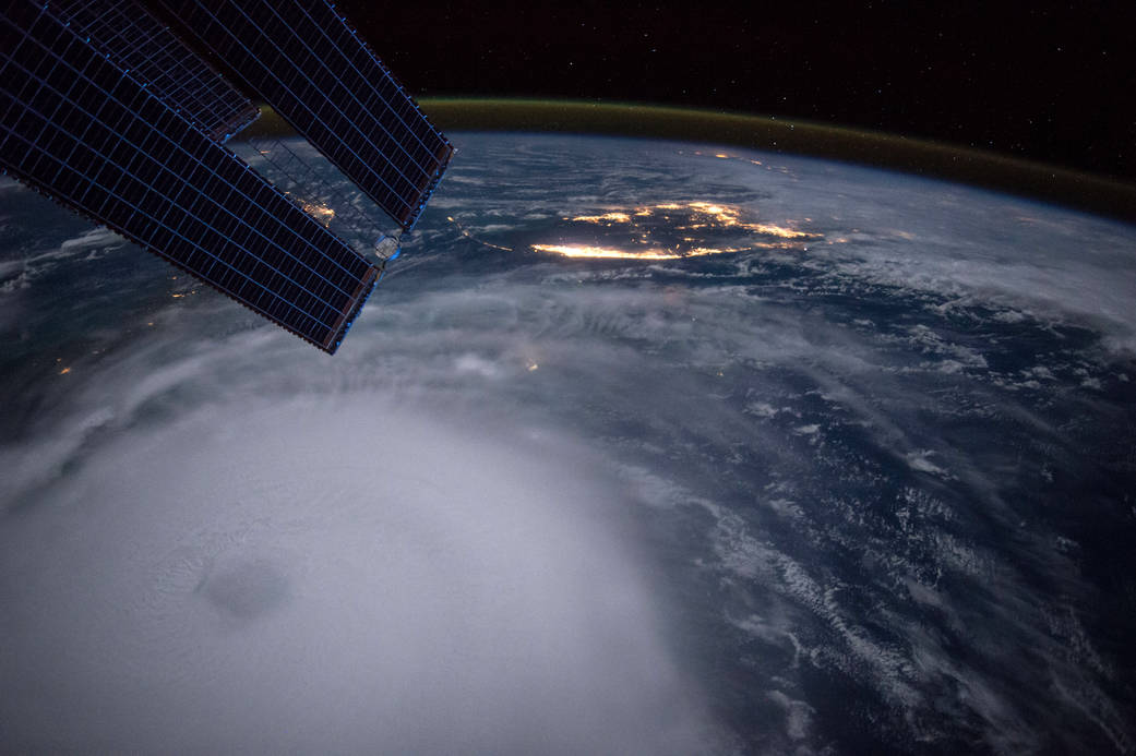
Hurricane "Joaquin" as viewed from the International Space Station, October 2, 2015. Image credit: Scott Kelly, NASA
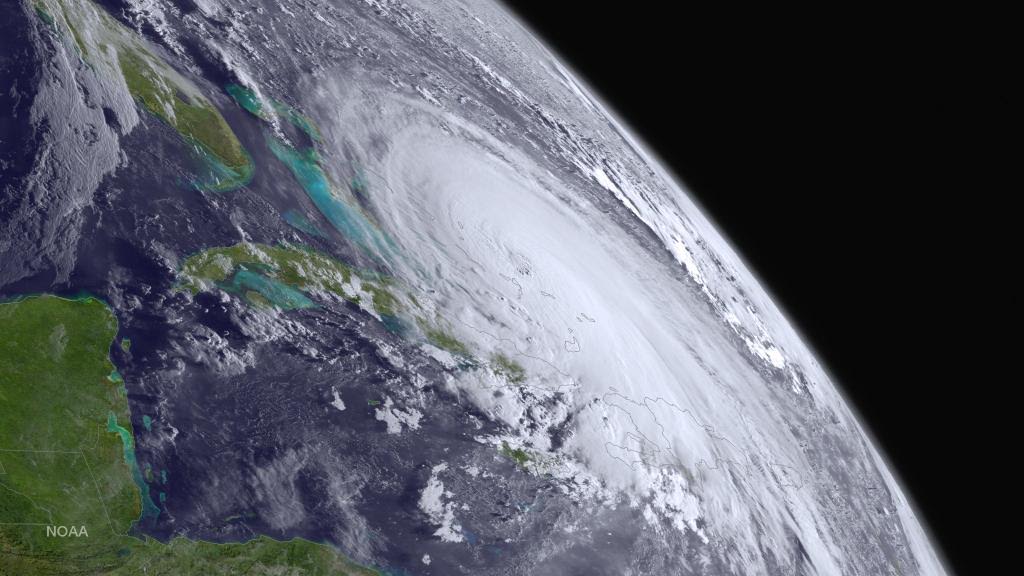
Hurricane "Joaquin", October 1, 2015. Image credit: NOAA GOES/West
At the time, Joaquin was packing maximum sustained winds of 205 km/h (125 mph) and moving northward at 11 km/h (7 mph). Minimum central pressure was reported at 942 hPa.
The hurricane is expected to turn northeastward and gain forward speed on the night of October 2 to 3, and this motion will most likely continue through October 4. Hurricane wind force extend up to 85 km ( 50 miles) outward from the center, with tropical storm winds reaching up to 355 km (205 miles) outward. Slow weakening is forecast over the next 48 hours, according to NHC.
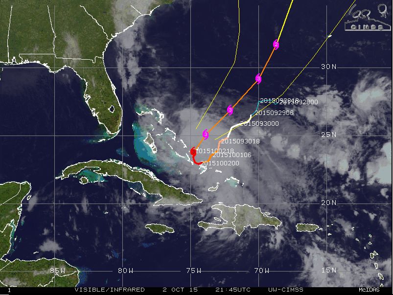
Hurricane "Joaquin", synoptic situation and track of movement, October 2, 2015, 21:45 UTC. Image credit: UW-CIMSS
Hurricane and tropical storm conditions will continue to affect part of Bahamas through the night of October 2 to 3. Tropical storm conditions are possible on Bermuda on October 4.
#Joaquin continues to batter Bahamas. Looks dangerous and impressive on satellite. http://t.co/dvXnJQN99G pic.twitter.com/AsjCtrBTbw
— Weather Underground (@wunderground) October 2, 2015
A very dangerous and life-threatening storm surge is expected to rise the water levels by 1.8 to 3.5 m (6 to 12 feet) above the usual tide levels in the central Bahamas, while 0.6 to 1.2 (2 to 4 feet) rise is possible across the rest of Bahamas within the hurricane warning area. The surge will be accompanied by large and dangerous waves near the shores.
A total of 304.8 to 457.2 mm (between 12 and 18 inches) of rain is expected to accumulate over the central Bahamas, locally up to 635 mm (25 inches), while the rest of the Bahamas will see 50.8 to 127 mm ( 2 to 5 inches) of precipitation. This rainfall could result in life-threatening flash floods.
Hurricane "Joaquin" 5-day track forecast. Image credit: NOAA/NWS
Joaquin will be generating large swells that will continue to affect the Bahamas in the next couple of days. Powerful swells have already began to affect parts of the southeast US coast and will spread toward the north through the weekend, starting on October 3. According to the latest modeling results, the system will pass well of the US coast, however a prolonged period of elevated water levels and large waves will affect the mid-Atlantic region, causing significant beach and dune erosion with likely moderate coastal flooding, NHC forecasts.
The southeast US is nevertheless in serious danger of record-breaking floods, as the moisture from Hurricane "Joaquin" is joining forces with a slow-moving front already affecting the shores with torrential rainfalls. Power outages, property damage and life-threatening situations are expected across the affected ares.
Video credit: AccuWeather
Residents in low-lying coastal and inland areas are warned to take precaution measures, closely follow further development and be ready to evacuate if necessary.
but global warming was suppose to bring more huricanes al gore said so! It’s all a Lie
This comment bypasses H. Sandy, perhaps the 2nd most-devastating hurricane in U.S. history, from 2012. Yes, it had weakened to a category II by landfall–small comfort to those who experienced it. It was still the largest Atlantic hurricane on record.
Joaquin Misses The US, Thus The 10-Year Hurricane Drought Continue
The U.S. has not seen a major hurricane — Category 3 or higher — make landfall since Hurricane Wilma hit on Oct. 24 2005. The nearly decade-long hurricane drought has come as a big surprise to climate scientists and environmentalists who have argued that global warming will make storms more frequent and intense