
Arctic air brings dangerously cold temperatures to much of the Central and Eastern U.S.
_end_jan_8.jpg)
Featured image: Minimum temperatures for January 8, 2015 expressed in degrees Celsisus (°C). Credit: NOAA / NWS
Arctic air is settling southward from Canada into the central and eastern U.S. This will cause dangerously cold temperatures to be felt by a large portion of country for the next few days, the U.S. National Weather Service (NWS) warns.
Temperatures will be 20 to 25 degrees below average from the Tennessee Valley to the Mid-Atlantic, their Short Range Public Discussion issued 07:48 UTC today says.
Heavy lake effect snow will develop downwind from the Great Lakes.
Cold high pressure over the Southern Plains to the Tennessee Valley will move eastward off the Southeast Coast by Friday morning, January 9, 2015.
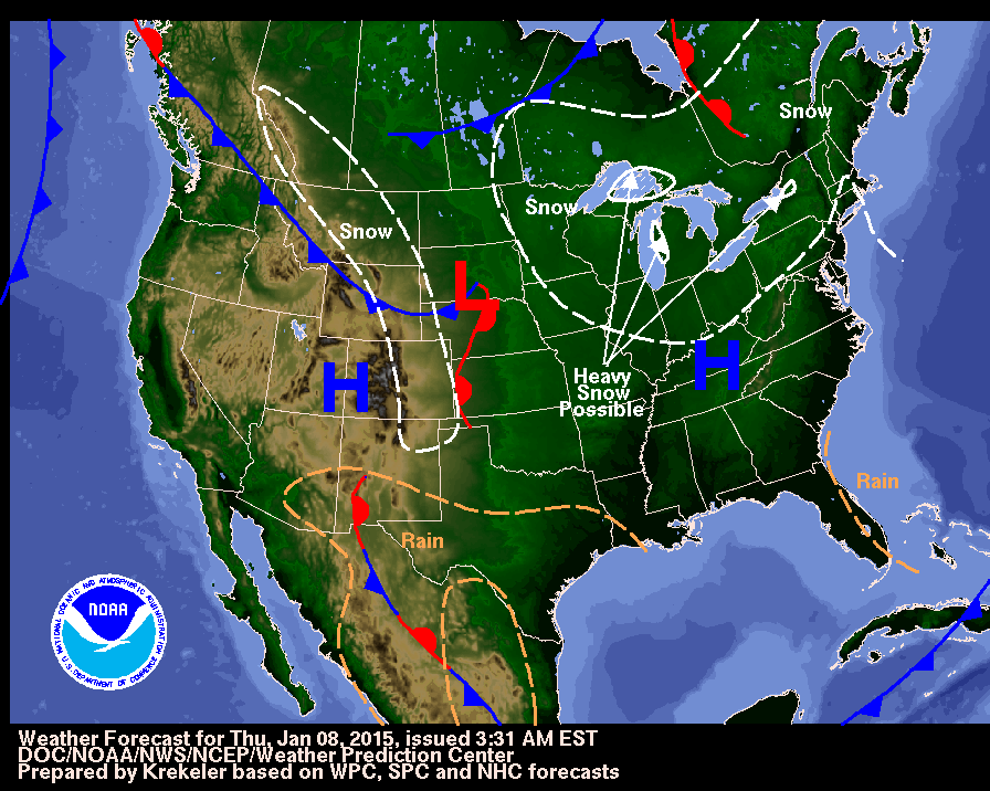
A second cold high pressure center over West-Central Canada will move southeastward to the Central/Southern Plains by Friday evening. Upslope flow associated with the circulation around the second high pressure will aid in producing light snow over parts of the Northern High Plains that will move to the Central High Plains by Friday morning before ending by Friday afternoon.

Minimum temperatures for January 8, 2015. Credit: NOAA / NWS. Note: values expressed in Metric units (°C)
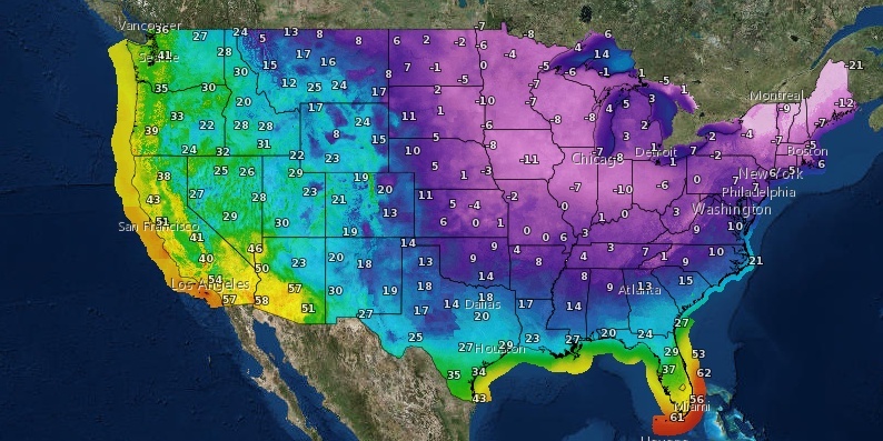
Minimum temperatures for January 8, 2015. Credit: NOAA / NWS. Note: values expressed in English units (°F)
Meanwhile, cold air moving over the Great Lakes and upper-level energy will aid in producing lake effect snow downwind from the Great Lakes on Thursday morning.
A developing clipper system will move eastward from the Northern Plains to the Great Lakes by early Friday morning and then northeastward to Eastern Canada by Friday evening.
The associated cold front will move eastward and off the East Coast by Friday afternoon. The system will produce light snow over parts of the Upper Mississippi Valley on Thursday morning and lake enhanced snow over the Great Lakes Thursday afternoon through Friday morning.
Hand warmers anyone? What a great photo of #Chiberia at -30 good morning Chitown 🙂 @cbschicago pic.twitter.com/Du5G5YbjVH
— Dave Savini (@davesavinicbs2) January 7, 2015
Where is cold air coming from? Air mass was near Arctic Circle in northern Canada as of 3-4 days ago. #ArcticBlast pic.twitter.com/qGKpyw0qAH
— NWS Tallahassee (@NWSTallahassee) January 7, 2015
Snow will be heavy downwind from the Great Lakes Friday morning into Friday evening.
Moisture trying to move northward from the Western Gulf of Mexico will produce areas of rain/freezing rain over parts of Southwest Texas on Thursday morning.
The moisture will continue to move northward and produce light rain over parts of Southern Texas and the Southwest Thursday evening into Friday morning. The rain will be restricted to Southern Texas by Friday evening. (NWS/Short Range Public Discussion issued 07:48 UTC on January 8, 2015)
See also
- Frigid temperatures arrive courtesy of Siberia; commute issues ahead, Canada
- Hazardous winter conditions expected in Newfoundland, Canada
I'm a dedicated researcher, journalist, and editor at The Watchers. With over 20 years of experience in the media industry, I specialize in hard science news, focusing on extreme weather, seismic and volcanic activity, space weather, and astronomy, including near-Earth objects and planetary defense strategies. You can reach me at teo /at/ watchers.news.
Why is it that cold in the USA? Cause of HAARP????