
Mount Gamalama eruption sends ash and rocks 2 km into the sky, Indonesia
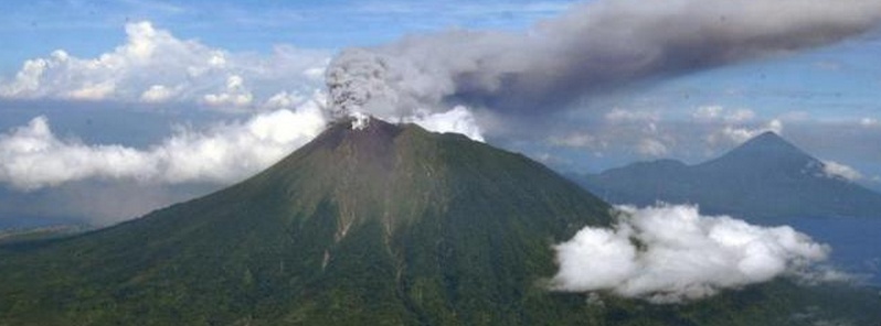
Image credit: Mount Gamalama eruption (via Viva.co.id)
Mount Gamalama in North Maluku province of Indonesia erupted at 13:41 UTC on Thursday, December 18, 2014, sending ash and rocks 2 km into the sky and forcing the authorities to close an airport and issue warnings to planes. Nine people were injured while running to escape the eruption. One person is still unaccounted for, authorities said.
Increased seismicity around the volcano was observed since 08:30 UTC. It then sharply increased at 13:09 UTC (22:09 local time), about 30 minutes before the eruption.
Evacuation orders are still not in place, however, a senior official from the disaster management agency in North Maluku province said the communities are ordered to be on alert of possible cool lava flowing in rivers as rain is frequent in recent days.
Sutopo Nugroho, a spokesman for the National Disaster Management Agency, said the volcanic ash was still blanketing much of the city of Ternate on Friday morning.
Meanwhile, USGS is registering a swarm of earthquakes about 150 km NW of Gamalama. They registered 67 moderate to strong earthquakes in the region (Molucca Sea) with magnitudes ranging from 4.0 – 6.8 in last 30 days.
http://t.co/S6CafrxESG 1 Pendaki Hilang Saat #gunung #gamalama Meletus pic.twitter.com/AzjEEidUn6
— Warta Mix (@wartamix) December 19, 2014
The last time this volcano appeared in GVP's weekly volcanic report was during the week of October 10 – 16, 2012:
CVGHM reported that eruptions at Gamalama during September 15 – 16 prompted CVGHM to raise the Alert Level to 3 (on a scale of 1-4) on September 16. An eruption on September 17 produced a white-and-gray plume that rose 300 m above the crater and drifted E and SE. Ashfall was reported in the ESE part of Ternate (S, SE, and E part of island). After the eruption through October 8 white plumes rose 10-50 m high. Seismicity decreased in early October. The Alert Level was decreased to 2 on October 9. Visitors and residents were warned not to approach the crater within a radius of 1.5 km.
Geologic summary
Gamalama (Peak of Ternate) is a near-conical stratovolcano that comprises the entire island of Ternate off the western coast of Halmahera and is one of Indonesia's most active volcanoes. The island of Ternate was a major regional center in the Portuguese and Dutch spice trade for several centuries, which contributed to the thorough documentation of Gamalama's historical activity.
Three cones, progressively younger to the north, form the summit of Gamalama, which reaches 1715 m. Several maars and vents define a rift zone, parallel to the Halmahera island arc, that cuts the volcano. Eruptions, recorded frequently since the 16th century, typically originated from the summit craters, although flank eruptions have occurred in 1763, 1770, 1775, and 1962-63. (GVP)
I'm a dedicated researcher, journalist, and editor at The Watchers. With over 20 years of experience in the media industry, I specialize in hard science news, focusing on extreme weather, seismic and volcanic activity, space weather, and astronomy, including near-Earth objects and planetary defense strategies. You can reach me at teo /at/ watchers.news.
Commenting rules and guidelines
We value the thoughts and opinions of our readers and welcome healthy discussions on our website. In order to maintain a respectful and positive community, we ask that all commenters follow these rules.