
Typhoon “Phanfone” intensifies, heading toward southern Japan
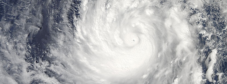
Featured image: Typhoon "Phanfone" on October 2, 2014. Image credit: NASA Aqua/MODIS
Tropical Storm "Phanfone" formed on September 29, 2014, east of Guam (Northwestern Pacific Ocean) and soon triggered tropical storm warnings for Saipan, Tinian, Pagan and Alamagan and a typhoon watch for the northern Marianas Islands, including Pagan and Alamagan.
At 15:00 UTC that day, Phanfone had maximum sustained winds near 40 knots (46 mph/74 km/h). It was centered about 270 nautical miles (310 miles/500 km) east-southeast of Saipan and moving west-northwest at 11 knots (12.6 mph/20.3 km/h).
The Joint Typhoon Warning Center (JTWC) noted that animated multi-spectral satellite imagery on September 30 revealed that the tropical storm had slightly unraveled as the bands of thunderstorms had become even more fragmented than they were on September 29. At 15:00 UTC, Phanfone's maximum sustained winds were near 45 knots (83.3 mph/51.7 km/h). It was centered about 103 nautical miles (118 miles/190 km) north of Saipan.
The system was intensifying and moving to the west-northwest toward the island of Iwo at 15 knots (17.2 mph/17.7 km/h).
NASA’s TRMM satellite saw Phanfone was producing rainfall over a very large area on October 1. Some storms in these bands were dropping rain at a rate of over 76 mm (almost 3 inches) per hour. Image credit: SSAI/NASA, Hal Pierce
Phanafone reached typhoon strength on Wednesday, October 1. At 15:00 UTC that day, it had maximum sustained winds near 70 knots (80 mph/129 km/h) and was centered about 348 nautical miles (400 miles/644.5 km) south of the island of Iwo To, Japan.
Its eye appeared the size of a pinhole on visible imagery from NASA's Aqua satellite earlier today (October 2). The tiny open eye of the storm was surrounded by a thick band of thunderstorms. The image also showed a very thick and large band of thunderstorms south of the center and spiraling into the eye.
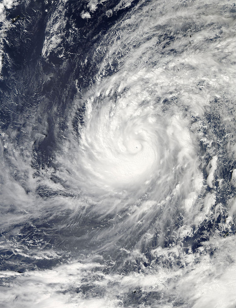
NASA's Aqua satellite captured this image of Typhoon Phanfone moving through the Northwestern Pacific Ocean on October 2 at 04:20 UTC. Image credit: NASA's Goddard Space Flight Center
Phanfone's maximum sustained winds strengthened to 110 knots (126.6 mph/ 203.7 km/h) at 18:00 UTC today. It was centered about 332 nautical miles (382.1 miles/614.9 km) southwest of the island of Iwo To. Its maximum significant wave height at the time was 40 feet (12 meters).
The system is expected to further intensify and reach maximum sustained winds of 125 knots (143 mph/231 km/h) and wind gusts of 150 knots (172 mph/277 km/h) on October 4 at ~06:00 UTC.
Phanfone is moving to the northwest and is expected to continue in that direction before turning to northeast on October 4 south of the Kyushu Province of Japan. Kyushu is the third largest island of Japan and most southwesterly of its four main islands.
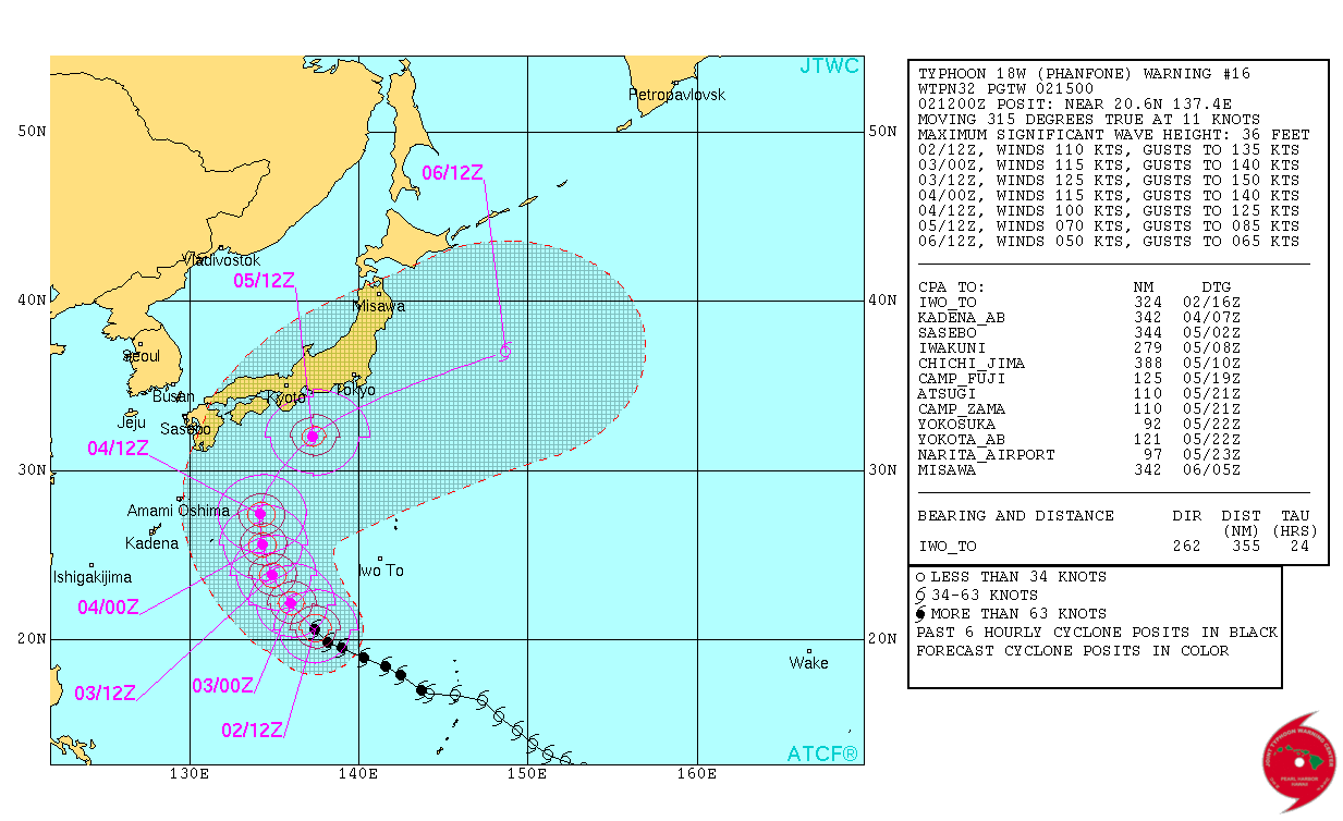
Typhoon "Phanfone" forecast track by JTWC on October 2, 2014.
JTWC expects it to begin weakening on October 4 as it begins a transition to an extra-tropical cyclone.
Satellite animations
- Storm-Centered Infrared (MTSAT2; NOAA/SSD)
- Storm-Centered Infrared (Aviation Color Enhancement) (MTSAT2; NOAA/SSD)
- Storm-Centered Water Vapor (MTSAT2; NOAA/SSD)
- Storm-Centered Visible (MTSAT2; NOAA/SSD)
- Storm-Centered Visible (Colorized) (MTSAT2; NOAA/SSD)
- Storm-Centered Infrared (MTSAT2; CIMSS)
- Storm-Centered Enhanced Infrared (MTSAT2; CIMSS)
- Storm-Centered Water Vapor (MTSAT2; CIMSS)
- Storm-Centered Visible (MTSAT2; CIMSS)
- Tropical West Pacific Infrared (MTSAT2; NOAA)
- Tropical West Pacific Enhanced Infrared (MTSAT2; NOAA)
- Tropical West Pacific Water Vapor (MTSAT2; NOAA)
- Tropical West Pacific Visible (MTSAT2; NOAA)
I'm a dedicated researcher, journalist, and editor at The Watchers. With over 20 years of experience in the media industry, I specialize in hard science news, focusing on extreme weather, seismic and volcanic activity, space weather, and astronomy, including near-Earth objects and planetary defense strategies. You can reach me at teo /at/ watchers.news.
Commenting rules and guidelines
We value the thoughts and opinions of our readers and welcome healthy discussions on our website. In order to maintain a respectful and positive community, we ask that all commenters follow these rules.