
Historic rainfall records broken – Eastern U.S. deluge in numbers
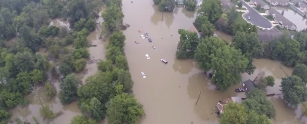
Image credit: Jake Schultz
In somewhat similar situation to major flooding in The Balkan Peninsula during May 2014 parts of American East experienced what some local officials call "unprecedented deluge" over the last couple of days when a slow-moving storm system dropped record breaking rainfall and caused historic flooding. Parts of New York state saw an entire summer's worth of rain in just 12 hours.
Detroit, Michigan
After thunderstorms and historic rainfall on Monday, August 11, Detroit metro area and parts of southeast Michigan experienced one of the worst flooding in their history. The Weather Channel reported that "some of the heaviest rain came in the 6 p.m. hour, when 1.24 inches (31.4 mm) of rain fell at Detroit Metropolitan Airport in just 24 minutes, part of a record-breaking 4.57 inches (116 mm) of total rainfall for the day."
Wow: Record-setting rain Monday flooded #Detroit freeways. PHOTOS via @FOX2News: http://t.co/jeBTY8JhK9 pic.twitter.com/aVQj4rpxdD
— FOX 5 DC (@fox5newsdc) August 13, 2014
It was Detroit's heaviest rain day in 89 years. Three people died and thousands of motorists were caught on flooded freeways during the afternoon rush.
Rainfall records for Detroit:
- (1) 4.74" (120 mm) on July 31, 1925
- (2) 4.57" (116 mm) on August 11, 2014
- (3) 4.51" (114.5 mm) on August 17, 1926
- (4) 4.34" (110.2 mm) on July 7, 1998
Flooding disaster in metro Detroit. Video courtesy of WXYZ-TV Detroit / Channel 7
Aerial Drone Video of flood waters over Hayes Road between Clinton River Road and Utica Road, August 12, 2014. The location is approximately 16.5 North of Detroit, Michigan, in Southeast Macomb County. Video courtesy of Jake Schultz.
Michigan Governor Rick Snyder issued a disaster declaration for the Detroit area on Wednesday, August 13.
Baltimore, Maryland
On Tuesday, August 12, the same storm caused major flooding events in Baltimore, Maryland. It was the second heaviest rainfall day in its recorded history with 6.30" (160 mm) of rain. Baltimore's wettest day in history is August 12, 1933, with 7.62" (193.5 mm).
Weather station at BWI airport measured 4.19" (106.4 mm) of rain in just two hours, between 11:54 a.m. and 1:54 p.m. According to NOAA data, Baltimore can expect a two-hour rainfall total of 4.19 inches about once every 100 years. (TWC)
#flooding at @BWI_Airport long term parking off of aviation Blvd from Trey Palmisano. Radar est. 3"+ rain so far pic.twitter.com/KhsHHhKFJf
— Justin Berk (@JustinWeather) August 12, 2014
Long Island, New York
On Wednesday, August 13, over 13 inches (330 mm) of rain fell in just over 9 hours in some parts of Long Island, New York. A state emergency has been declared in Suffolk County and the town of Islip which set a new 24-hour rainfall record for the state of New York with 13.57" (344.6 mm). The previous state record was from Hurricane/Tropical Storm Irene, which dropped 11.60" (294.6 mm) at Tannersville on August 27-28, 2011.
One person died in a traffic accident on Long Island Expressway.
Harrowing Scenes From The Flash Flooding On Long Island http://t.co/W6NR5g7jux pic.twitter.com/YOeks2sdBB
— Gothamist (@Gothamist) August 13, 2014
#Stormwatch In Bay Shore #longisland pic.twitter.com/EFEfh16MYW
— Anik Solaris (@AnikSolaris) August 13, 2014
Dramatic before and after photos of flooded backyard in West Islip, NY http://t.co/ENPFVICXTt pic.twitter.com/DCVmXq2lT7
— NBC New York (@NBCNewYork) August 13, 2014
Other parts of US
Nebraska
A hospital in Nebraska was dramatically flooded over the weekend. There were no injuries, but there was significant damage to the hospital which could remain closed for some time.
Video courtesy: Good Samaritan Hospital – Kearney, NE
Washington
Several houses were inundated with flood water thigh high after heavy rainfall early Wednesday, August 13. A storm dumped around 2 inches (50 mm) of rain in a two-hour period, pushing levels of the Kelsey Creek to overflow into nearby homes. The storm also caused damage elsewhere, leaving 4 000 homes without power.
Arizona
3.55 inches (90 mm) of rain fell in 24 hours between August 13 and 15 in the Phoenix area, Arizona. Several houses were inundated in the south Mountains area of the city. (Floodlist)
Signs of a wetter future
In their yesterday's article, The Weather Channel explains if the extremity of recent rainfall is solely a reflection of a favorable sluggish weather pattern, or is the Earth's changing climate also playing the role?
Quote from the article: "The National Climate Assessment, a report compiled by 300 scientists and experts released in May 2014, offered compelling evidence that, in fact, heavy rain events are becoming, well, heavier in parts of the U.S.
Specifically, the NCA report first concluded that the intensity of heavy rain events is increasing nationwide, with the greatest rises occurring in the Northeast and Midwest (see map at right). In other words, the heaviest rain events are producing more rain now than in the middle of the 20th Century, particularly in the eastern half of the nation."
They further explain that these heavy rain events are becoming more frequent, as you can see in the graph below, taking off particularly since the 1980s.
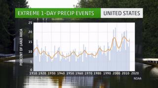
Image credit: The Weather Channel. Data: NOAA.
Future climate forecasts suggest the number of heavy rain events will continue to rise nationwide, even in regions where overall less precipitation is expected, such as the Desert Southwest, according to the NCA report. (TWC)
Read the rest of their article here.
I'm a dedicated researcher, journalist, and editor at The Watchers. With over 20 years of experience in the media industry, I specialize in hard science news, focusing on extreme weather, seismic and volcanic activity, space weather, and astronomy, including near-Earth objects and planetary defense strategies. You can reach me at teo /at/ watchers.news.
Commenting rules and guidelines
We value the thoughts and opinions of our readers and welcome healthy discussions on our website. In order to maintain a respectful and positive community, we ask that all commenters follow these rules.