
Very strong and shallow M 6.9 earthquake struck Greece (Aegean Sea) – strong aftershocks continue
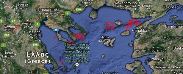
Image credit: Google Maps / EMSC
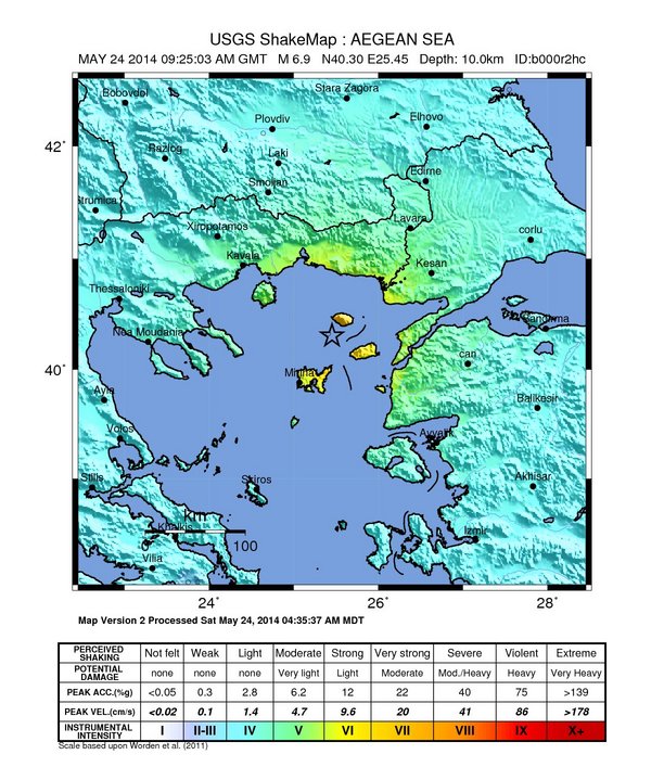
A very strong and shallow earthquake struck off the coast of Greece on May 24, 2014 at 09:25 UTC (11:25 local time). After preliminary analysis both USGS and EMSC report M 6.9 earthquake. EMSC is reporting depth of 29 km, USGS 10 km.
Epicenter was located 19 km (12 miles) S of Kamariotissa, 298 km (185 miles) NNE of capital Athens, Greece and 83 km (52 miles) WNW of Canakkale, Turkey.
There are 491 015 people living within 100 km radius. The tremors from this earthquake were felt in all surrounding countries and as far as Israel.
USGS issued green alert for shaking-related fatalities – there is a low likelihood of casualties. Yellow alert was issued for economic losses. Some damage is possible and the impact should be relatively localized. Estimated economic losses are less than 1% of GDP of Greece. Past events with this alert level have required a local or regional level response.
EMSC is reporting numerous aftershocks in the area. Many aftershocks are striking very close to the Canakkale coast, Turkey.
Overall, the population in this region resides in structures that are a mix of vulnerable and earthquake resistant construction.
The damage in Turkey is far bigger than in Greece.
ER reported there was huge panic while the shaking started in Canakkale Turkey – check this Hurryet video.
Seismologist Dr. Stephen Hicks said on his Twitter account that this earthquake occurred along the westernmost strand of the Northern Anatolian Fault system. Today’s earthquake looks to be the largest recorded in this part of the fault since detailed records are available (1970).
By 14:10 UTC official numbers are mentioning 266 people injured, 1 seriously, in Turkey. One person was injured in Greece.
Latest updates can be found on Earthquake-Report.com.
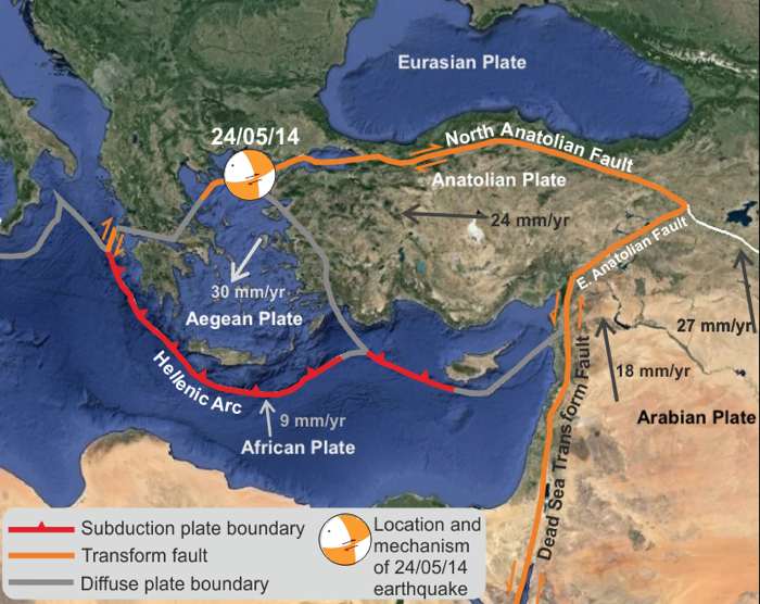
Image courtesy Dr. Stephen Hicks
Population exposure
Population per ˜1 sq. km. from LandScan
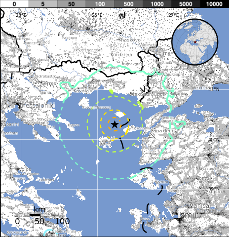
Selected cities exposed
from GeoNames Database of Cities with 1,000 or more residents.
| MMI | City | Population |
|---|---|---|
| VIII | Kamariotissa | 1k |
| VII | Samothraki | <1k |
| VI | Gokceada | 8k |
| VI | Alexandroupoli | 53k |
| VI | Enez | 4k |
| VI | Bozcaada | 3k |
| IV | Thessaloniki | 354k |
| IV | Balikesir | 238k |
| IV | Plovdiv | 340k |
| IV | Manisa | 244k |
| IV | Izmir | 2,501k |
(k = x1,000)
Seismotectonics of the Mediterranean Region and Vicinity
The Mediterranean region is seismically active due to the northward convergence (4-10 mm/yr) of the African plate with respect to the Eurasian plate along a complex plate boundary. This convergence began approximately 50 Ma and was associated with the closure of the Tethys Sea. The modern day remnant of the Tethys Sea is the Mediterranean Sea. The highest rates of seismicity in the Mediterranean region are found along the Hellenic subduction zone of southern Greece, along the North Anatolian Fault Zone of western Turkey and the Calabrian subduction zone of southern Italy. Local high rates of convergence at the Hellenic subduction zone (35mm/yr) are associated with back-arc spreading throughout Greece and western Turkey above the subducting Mediterranean oceanic crust. Crustal normal faulting throughout this region is a manifestation of extensional tectonics associated with the back-arc spreading. The region of the Marmara Sea is a transition zone between this extensional regime, to the west, and the strike-slip regime of the North Anatolian Fault Zone, to the east. The North Anatolian Fault accommodates much of the right-lateral horizontal motion (23-24 mm/yr) between the Anatolian micro-plate and Eurasian plate as the Anatolian micro-plate is being pushed westward to further accommodate closure of the Mediterranean basin caused by the collision of the African and Arabian plates in southeastern Turkey. Subduction of the Mediterranean Sea floor beneath the Tyrrhenian Sea at the Calabrian subduction zone causes a significant zone of seismicity around Sicily and southern Italy. Active volcanoes are located above intermediate depth earthquakes in the Cyclades of the Aegean Sea and in southern Italy.
In the Mediterranean region there is a written record, several centuries long, documenting pre-instrumental seismicity (pre-20th century). Earthquakes have historically caused widespread damage across central and southern Greece, Cyprus, Sicily, Crete, the Nile Delta, Northern Libya, the Atlas Mountains of North Africa and the Iberian Peninsula. The 1903 M8.2 Kythera earthquake and the 1926 M7.8 Rhodes earthquakes are the largest instrumentally recorded Mediterranean earthquakes, both of which are associated with subduction zone tectonics. Between 1939 and 1999 a series of devastating M7+ strike-slip earthquakes propagated westward along the North Anatolian Fault Zone, beginning with the 1939 M7.8 Erzincan earthquake on the eastern end of the North Anatolian Fault system. The 1999 M7.6 Izmit earthquake, located on the westward end of the fault, struck one of Turkey's most densely populated and industrialized urban areas killing, more than 17,000 people. Although seismicity rates are comparatively low along the northern margin of the African continent, large destructive earthquakes have been recorded and reported from Morocco in the western Mediterranean, to the Dead Sea in the eastern Mediterranean. The 1980 M7.3 El Asnam earthquake was one of Africa's largest and most destructive earthquakes within the 20th century.
Large earthquakes throughout the Mediterranean region have also been known to produce significant and damaging tsunamis. One of the more prominent historical earthquakes within the region is the Lisbon earthquake of November 1, 1755, whose magnitude has been estimated from non-instrumental data to be about 8.0. The 1755 Lisbon earthquake is thought to have occurred within or near the Azores-Gibraltar transform fault, which defines the boundary between the African and Eurasian plates off the west coast of Morocco and Portugal. The earthquake is notable for both a large death toll of approximately 60,000 people and for generating a tsunami that swept up the Portuguese coast inundating coastal villages and Lisbon. An earthquake of approximately M8.0 near Sicily in 1693 generated a large tsunami wave that destroyed numerous towns along Sicily's east coast. The M7.2 December 28, 1908 Messina earthquake is the deadliest documented European earthquake. The combination of severe ground shaking and a local tsunami caused an estimated 60,000 to 120,000 fatalities.
I'm a dedicated researcher, journalist, and editor at The Watchers. With over 20 years of experience in the media industry, I specialize in hard science news, focusing on extreme weather, seismic and volcanic activity, space weather, and astronomy, including near-Earth objects and planetary defense strategies. You can reach me at teo /at/ watchers.news.
shake rattle and roll
There are clues that it was a double shock: the waves from the western shock triggered another shock towards the east. The waves went on phase towards the east (Turkey) and this is why it did damage there. Here in Greece it was clearly felt as a double or multiple shock with 2 clusters. Very unusual earthquake, I have felt a lot of quakes but this one was unusual.