
Balkan continues to fight with historic floods
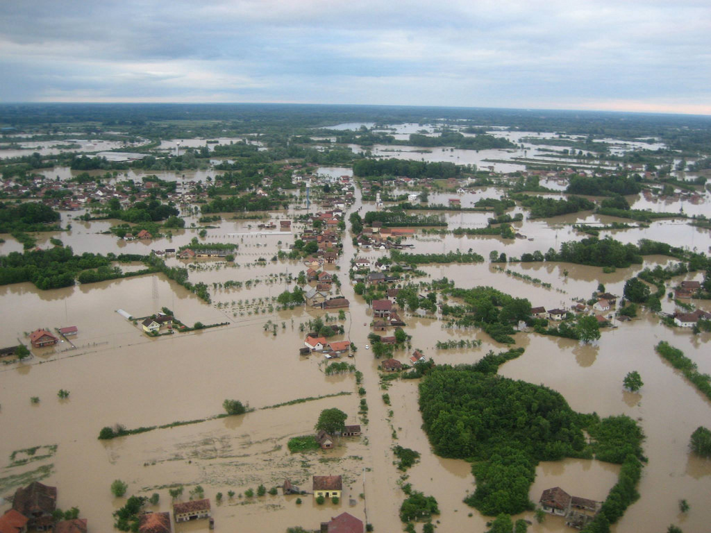
Image credit: EU Response to Serbia and Bosnia and Herzegovina floods by http://www.flickr.com/photos/69583224@N05/14218015071
Devastating floods continue to affect Croatia, Bosnia and Herzegovina and Serbia. More than 2.5 million people have been affected, nearly one million people have been displaced and lost access to clear water. At least 100 000 structures and homes were destroyed.
Continuous rainfall has caused landslides and severe flooding in Serbia and Bosnia-Herzegovina. This catastrophic flooding is considered the region’s worst flood in more than 120 years of record-keeping.
.png)
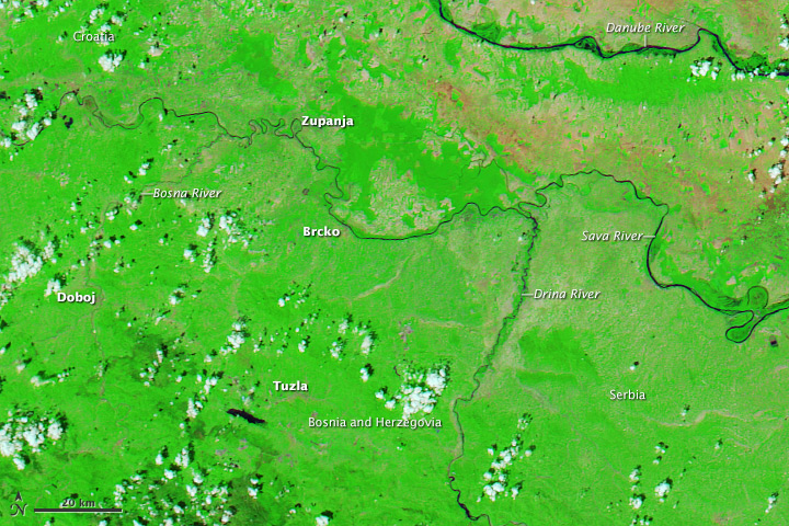
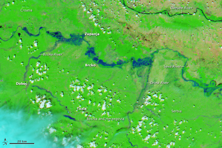
Suomi NPP satellite's VIIRS instrument captured this two satellite images. The top image was taken around 10: 50 UTCon May 7, 2014, and the bottom image around 12:07 UTC on May 19, 2014. (Credit: NASA/Suomi NPP)
More than 3000 landslides have been reported in Bosnia and Herzegovina and Serbia. The most pressing concerns are landslides, animal carcasses and debris. Another concern are old landmines shifted by the floods.
More than 40 people have lost their lives so far. Bosnia declared May 20, 2014, a day of mourning, while Serbia's government said it would mourn its dead from May 21 – 23, 2014.
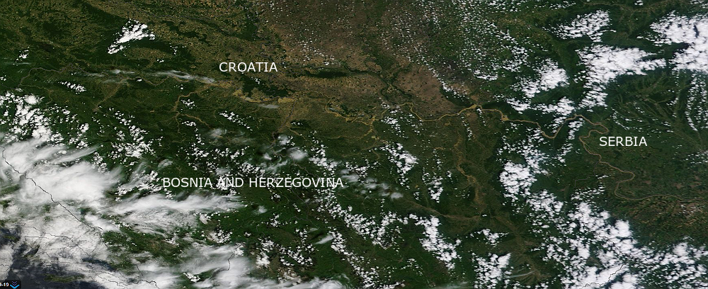
The Moderate Resolution Imaging Spectroradiometer (MODIS) on NASA’s Aqua satellite captured an image of affected area one year ago during a more typical spring, and again on May 19, 2014, showing catastrophic flooding in Croatia, Serbia, and Bosnia and Herzegovina. (NASA Earth Observatory/LANCE Rapid response/MODIS. Caption by Michael Carlowicz.)
Rivers in Serbia and Bosnia will continue rising this week, as rain-swollen tributaries still pour into river Sava. A new flood wave is expected to hit already hard hit areas. There are concerns that the Sava River, 18 miles downstream of Belgrade, will overwhelm the flood defenses of the Nikola Tesla complex – Serbia's largest power plant which provides half of the nation's power.
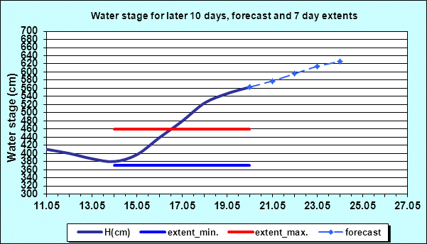
(Credit: Republic Hydrometeorological Service of Serbia)
Swollen river Sava and its tributaries seen on this MODIS satellite image taken on May 20, 2014 (Credit: LANCE Rapid Response/MODIS)
Extra-tropical storm Yvette (Tamara)
A strong and slow-moving upper-level low pressure area over Balkan Peninsula developed into an extra-tropical storm Yvette (locally called Tamara/Donat) and pulled in large amounts of moisture from the Mediterranean Sea from May 14 – 17, 2014. The area received three-months amount of rainfall in three days period. Torrential rains caused rivers to burst their banks and triggered hundreds of landslides.
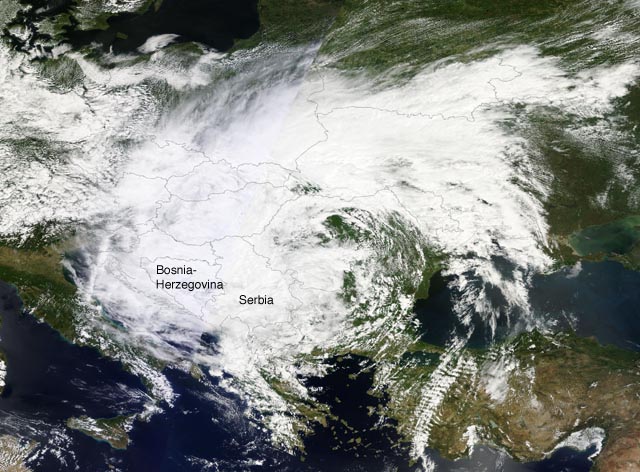
MODIS satellite image of Extratropical Storm Yvette (Tamara) taken on May 15, 2014. (Credit: LANCE Rapid Response/MODIS/NASA)
Q: Are there nuclear plants in this region?
Are they on back-up power?
Not in affected area FC