
Tropical Cyclone Edilson threatening Rodrigues Island and Mauritius
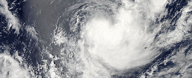
Featured image: TC Edilson on February 5, 2014. Image credit: NASA / Aqua
The thirteenth tropical cyclone of the Southern Indian Ocean season formed into a tropical storm named Edilson on February 5. The system formed north of Mauritius and is moving south. According to Goddard, it is threatening several land areas.
A Class I Cyclone Warning is now in effect for Rodrigues Island and a Class II Cyclone Warning is in effect for Mauritius.
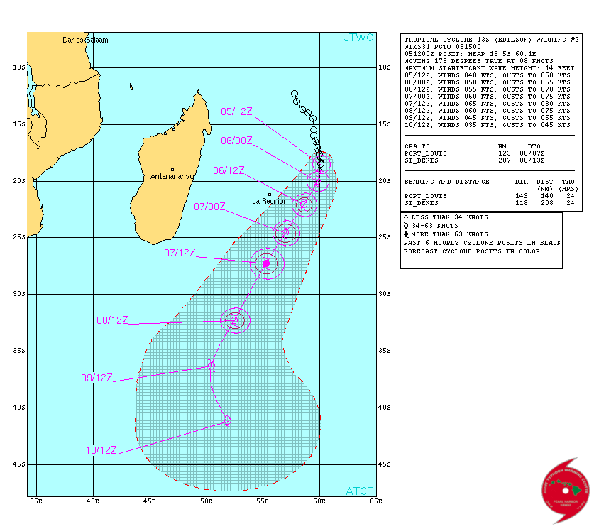
Edilson forecast track – February 5, 2014. Image credit: JTWC
At 09:50 UTC on February 5, NASA's Aqua satellite passed over Edilson and the Moderate Resolution Imaging Spectroradiometer or MODIS instrument captured a visible image of the storm.
The MODIS image showed a large broken band of thunderstorms to the north, and a large band of storms from the east, wrapping into the low-level center of circulation.
Edilson's center was to the northeast of the islands of Mauritius and La Reunion, and Edilson's eastern quadrant had spread clouds over Rodrigues Island of the Republic of Mauritius.
NASA's Aqua satellite captured this visible image of Tropical Cyclone Edilson in the Southern Indian Ocean on February 5 at 09:50 UTC, north of the islands of Mauritius and La Reunion (left). Image credit: NASA Goddard MODIS Rapid Response
The Atmospheric Infrared Sounder or AIRS instrument also aboard NASA's Aqua satellite captured infrared data on Edilson at the same time that showed strong thunderstorms with heavy rain potential around and north of the center. Cloud top temperatures in those areas were in excess of -63F/-52C.
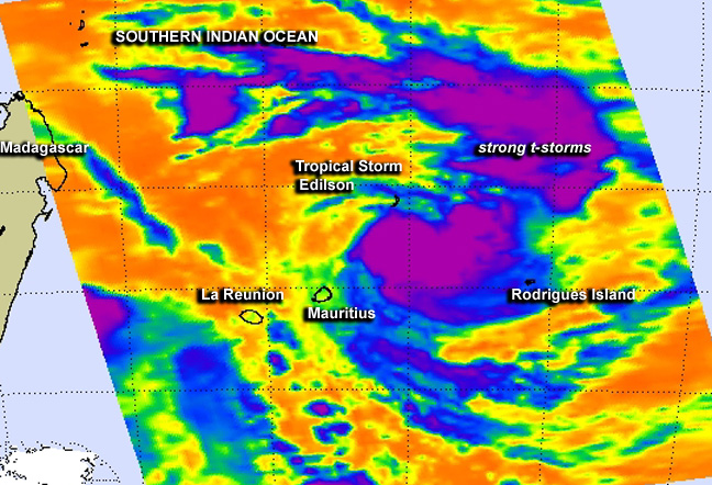
NASA's Aqua satellite captured this infrared image of Tropical Cyclone Edilson on February 5 at 09:47 UTC showing strong thunderstorms with heavy rain potential around and north of the center. Image credit: NASA JPL, Ed Olsen
On February 5 at 15:00 UTC, Edilson had maximum sustained winds near 40 knots/46 mph/73 km/h. The center of the tropical storm was about 297 nautical miles/341.8 miles/550 km northeast of Saint Denis, La Reunion Island, near 18.9 south latitude and 60.0 east longitude. Edilson is moving to the south at 8 knots/9.2 mph/14.8 kph.
Edilson is moving along the western edge of a mid-layered subtropical ridge (elongated area) of high pressure situated to the east of the tropical storm. As Edilson continues tracking along the high, it will begin to move more southward over the coming days.
The Joint Typhoon Warning Center expects Edilson to intensify to hurricane force briefly before weakening.
Source: Goddard / Rob Gutro
I'm a dedicated researcher, journalist, and editor at The Watchers. With over 20 years of experience in the media industry, I specialize in hard science news, focusing on extreme weather, seismic and volcanic activity, space weather, and astronomy, including near-Earth objects and planetary defense strategies. You can reach me at teo /at/ watchers.news.
Commenting rules and guidelines
We value the thoughts and opinions of our readers and welcome healthy discussions on our website. In order to maintain a respectful and positive community, we ask that all commenters follow these rules.