
Tropical Cyclone Helen makes landfall in India
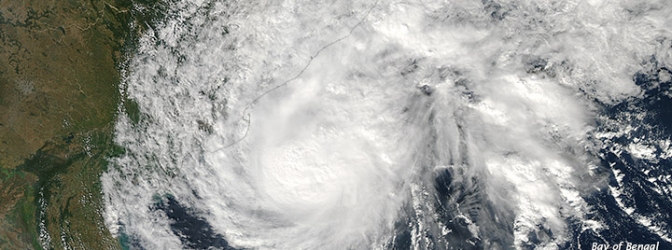
Image credit: The Moderate Resolution Imaging Spectroradiometer (MODIS) on NASA’s Aqua satellite captured this image of Cyclone 04B (Helen) on November 21, 2013. (NASA image by Jeff Schmaltz, LANCE/EOSDIS Rapid Response. Caption by Mike Carlowicz and Rob Gutro.)
Tropical Cyclone Helen, accompanied by strong winds and heavy rain, has made landfall near Machilipatnam, across the Andhra Pradesh in India. 8,000 people have been evacuated to safer places while two persons were killed in separate rain-related incidents as heavy rains lashed coastal districts of Andhra Pradesh. Wind gusts of 95 to 130 km/h (60 to 80 mph) were recorded.
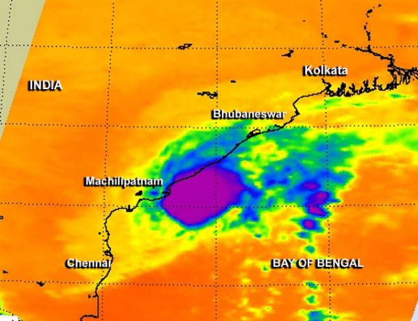
The AIRS instrument aboard NASA's Aqua satellite captured infrared data on Helen as it flew overhead on November 21 at 20:05 UTC. Helen's western cloud cover (yellow) extended from Kolkata south to Chennai at the time. (Credit: NASA JPL, Ed Olsen)
Rain amounts of around 100 mm (4 inches) with locally higher totals of 200 mm (8 inches) are expected across east-central Andhra Pradesh, significantly heightening the concern for flash flooding.
According to the latest report by Joint Typhoon Warning Center (JTWC), the center of Tropical Cyclone Helen was located approximately 193 nm north-northeastward of Chennai, India. The system is moving westward at speed of 7 knots. Tc Helen is expected to dissipate over land.
.jpg)
The Moderate Resolution Imaging Spectroradiometer (MODIS) on NASA’s Aqua satellite captured this image of Cyclone 04B (Helen) on November 21, 2013. (NASA image by Jeff Schmaltz, LANCE/EOSDIS Rapid Response. Caption by Mike Carlowicz and Rob Gutro.)
In the meantime, another tropical disturbance is taking shape in the Andaman Sea. Current indications point toward this possible cyclone taking aim at eastern India around the middle of next week.
.jpg)
Satellite Animations
- Storm-Centered Infrared (Meteosat 7; NOAA/SSD)
- Storm-Centered Infrared (Aviation Color Enhancement) (Meteosat 7; NOAA/SSD)
- Storm-Centered Water Vapor (Meteosat 7; NOAA/SSD)
- Storm-Centered Visible (Meteosat 7; NOAA/SSD)
- Storm-Centered Visible (Colorized) (Meteosat 7; NOAA/SSD)
- Storm-Centered Infrared (Meteosat 7; CIMSS)
- Storm-Centered Enhanced Infrared (Meteosat 7; CIMSS)
- Storm-Centered Water Vapor (Meteosat 7; CIMSS)
- Storm-Centered Visible (Meteosat 7; CIMSS)
- Meteosat 7 Infrared (Meteosat 7; CIMSS)
- Meteosat 7 Infrared (Color Background) (Meteosat 7; CIMSS)
- Meteosat 7 Infrared (NHC Color Enhancement) (Meteosat 7; CIMSS)
- Meteosat 7 Water Vapor (Meteosat 7; CIMSS)
- Meteosat 7 Water Vapor (Color Background) (Meteosat 7; CIMSS)
Commenting rules and guidelines
We value the thoughts and opinions of our readers and welcome healthy discussions on our website. In order to maintain a respectful and positive community, we ask that all commenters follow these rules.