
A portrait of global winds – GEOS-5
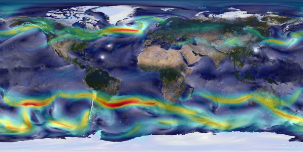
Image credit: William Putman/NASA Goddard Space Flight Center
New visualization by NASA’s Goddard Earth Observing System Model (GEOS-5) shows global winds simulation using 10-kilometer resolution. Surface winds (0 to 40 meters/second) are shown in white and trace features including Atlantic and Pacific cyclones. Upper-level winds (250 hectopascals) are colored by speed (0 to 175 meters/second), with red indicating faster.
High-resolution global atmospheric modeling provides a unique tool to study the role of weather within Earth’s climate system.

Image Credit: William Putman/NASA Goddard Space Flight Center
This simulation ran on the Discover supercomputer at the NASA Center for Climate Simulation. The complete 2-year “Nature Run” simulation—a computer model representation of Earth's atmosphere from basic inputs including observed sea-surface temperatures and surface emissions from biomass burning, volcanoes and anthropogenic sources—produces its own unique weather patterns including precipitation, aerosols and hurricanes. A follow-on Nature Run is simulating Earth’s atmosphere at 7 kilometers for 2 years and 3.5 kilometers for 3 months.

Published in the last 24 hours
- A Virginia park ranger was struck by lightning seven times and lived, even though three of the strikes set his hair on fire Epicenter
- The hole in the ozone layer over Antarctica was about twice the size of the US this year, and scientists say it would have been bigger still if ozone-eating chemicals were at their 2000 levels Epicenter

Commenting rules and guidelines
We value the thoughts and opinions of our readers and welcome healthy discussions on our website. In order to maintain a respectful and positive community, we ask that all commenters follow these rules.