
Active volcanoes in the world: June 26 – July 2, 2013
Image credit: TW
This week, 4 volcanoes had new activity, whereas ongoing activity was reported for 7 volcanoes. This report covers active volcanoes in the world recorded from June 26 – July 2, 2013 based on Smithsonian/USGS criteria.
New activity/unrest: | Chirinkotan, Kuril Islands | Pavlof, Alaska Peninsula | Shiveluch, Central Kamchatka (Russia) | Veniaminof, Alaska Peninsula
Ongoing activity: | Fuego, Guatemala | Kilauea, Hawaii (USA) | Kizimen, Eastern Kamchatka (Russia) | Pacaya, Guatemala | Sakura-jima, Kyushu | Santa María, Guatemala | Tolbachik, Central Kamchatka (Russia)
The Weekly Volcanic Activity Report is a cooperative project between the Smithsonian's Global Volcanism Program and the US Geological Survey's Volcano Hazards Program. Updated by 2300 UTC every Wednesday, notices of volcanic activity posted on these pages are preliminary and subject to change as events are studied in more detail. This is not a comprehensive list of all of Earth's volcanoes erupting during the week, but rather a summary of activity at volcanoes that meet criteria discussed in detail in the "Criteria and Disclaimers" section. Carefully reviewed, detailed reports on various volcanoes are published monthly in the Bulletin of the Global Volcanism Network.
New activity/unrest
CHIRINKOTAN, Kuril Islands
48.980°N, 153.480°E; summit elev. 724 m
Based on analysis of satellite images, SVERT reported that steam-and-gas emissions from Chirinkotan were detected on 25 and 26 June. The Aviation Color Code remained at Yellow.
Geologic summary: The small, mostly unvegetated 3-km-wide island of Chirinkotan occupies the far end of an E-W-trending volcanic chain that extends nearly 50 km west of the central part of the main Kuril Islands arc. Chirinkotan is the emergent summit of a volcano that rises 3000 m from the floor of the Kuril Basin. A small 1-km-wide caldera about 300-400 m deep is open to the SE. Lava flows from a cone within the breached crater reached the north shore of the island. Historical eruptions have been recorded at Chirinkotan since the 18th century. Fresh lava flows also descended the SE flank of Chirinkotan during an eruption in the 1880s that was observed by the English fur trader Captain Snow.
PAVLOF, Alaska Peninsula
55.42°N, 161.887°W; summit elev. 2519 m
According to news articles, ash plumes from Pavlof caused local airlines to cancel one flight and reroute six more on 25 June. AVO reported that during 25-26 June seismicity declined, and consisted of intermittent bursts of tremor and occasional small explosions. Satellite images showed a plume containing small amounts of ash drifting NW, and strong thermal anomalies at the summit. Pilot reports on 26 June indicated that plumes rose to altitudes between 6.1-7.6 km (20,000 to 25,000 ft) a.s.l., and then to heights just above the summit later that day. Seismicity during 26 June-1 July continued at low levels and consisted primarily of periodically continuous, low-level tremor. Thermal anomalies at the summit detected in satellite images were strong during 26-29 June and weak during 30 June-1 July.
Activity further declined during 1-2 July; tremor and explosions were no longer detected in seismic and pressure sensor data. Satellite images did not detect elevated surface temperatures, volcanic gas, or ash emissions, and there were no visual observations from pilots or from webcam images of any eruptive activity since 26 June. AVO lowered the Aviation Color Code to Yellow and the Volcano Alert Level to Advisory.
Geologic summary: The most active volcano of the Aleutian arc, Pavlof is a 2519-m-high Holocene stratovolcano that was constructed along a line of vents extending NE from the Emmons Lake caldera. Pavlof and its twin volcano to the NE, 2142-m-high Pavlof Sister, form a dramatic pair of symmetrical, glacier-covered stratovolcanoes that tower above Pavlof and Volcano bays. A third cone, Little Pavolf, is a smaller volcano on the SW flank of Pavlof volcano, near the rim of Emmons Lake caldera. Unlike Pavlof Sister, Pavlof has been frequently active in historical time, typically producing strombolian to vulcanian explosive eruptions from the summit vents and occasional lava flows. The active vents lie near the summit on the north and east sides. The largest historical eruption of Pavlof took place in 1911, at the end of a 5-year-long eruptive episode; a fissure opened on the northern flank of the volcano, ejecting large blocks and issuing lava flows.
SHIVELUCH, Central Kamchatka (Russia)
56.653°N, 161.360°E; summit elev. 3283 m
Based on visual observations and analyses of satellite data, KVERT reported that during 21-28 June a viscous lava flow effused on the N flank of Shiveluch's lava dome, accompanied by hot avalanches, incandescence, and fumarolic activity.
The seismic network detected a strong explosive eruption that occurred on 27 June from 0710 to 0800. The Aviation Color Code was raised to Red. Ash plumes drifted SE and SW, likely at altitudes of 10-12 km (33,000-39,400 ft) a.s.l. About 2 mm of red ash fell in Klyuchi Village, 50 km SW; ashfall was also reported in Lazo Village. Later that day the Alert Level was lowered back to Orange. Two ash explosions that occurred on 28 June at 0506 and 1001 produced ash plumes that rose to altitudes of 7 and 6 km (23,000 and 19,700 ft) a.s.l., respectively.
Based on analyses of satellite imagery, notices from Yelizovo Airport (UHPP), and the Kamchatka Branch of Geophysical Services (KBGS; Russian Academy of Sciences), the Tokyo VAAC reported that during 29-30 June an ash plume rose to altitudes of 5.5-6.4 km (18,000-21,000 ft) a.s.l. and drifted E and SE.
.jpg)
Ash covers the car in village beneath Shiveluch volcano on June 27, 2013 (Credit: Yu.Demyanchuk/Volkstat)
Geologic summary: The high, isolated massif of Shiveluch volcano (also spelled Sheveluch) rises above the lowlands NNE of the Kliuchevskaya volcano group and forms one of Kamchatka's largest and most active volcanoes. The currently active Molodoy Shiveluch lava-dome complex was constructed during the Holocene within a large breached caldera formed by collapse of the massive late-Pleistocene Strary Shiveluch volcano. At least 60 large eruptions of Shiveluch have occurred during the Holocene, making it the most vigorous andesitic volcano of the Kuril-Kamchatka arc. Frequent collapses of lava-dome complexes, most recently in 1964, have produced large debris avalanches whose deposits cover much of the floor of the breached caldera. Intermittent explosive eruptions began in the 1990s from a new lava dome that began growing in 1980. The largest historical eruptions from Shiveluch occurred in 1854 and 1964.
VENIAMINOF, Alaska Peninsula
56.17°N, 159.38°W; summit elev. 2507 m
AVO reported that the ongoing low-level eruption of Veniaminof, characterized by lava effusion and emission of minor amounts of ash and steam, continued during 26 June-2 July, indicated by nearly continuous volcanic tremor and occasional small explosions detected by the seismic network. Satellite images showed elevated surface temperatures at the cinder cone inside the caldera consistent with lava effusion. During 26-30 June web camera images from Perryville (32 km SSE) showed a small light-colored plume rising above the cone to just above the rim of the caldera, and night time images showed persistent incandescence from the cone. The Volcano Alert Level remained at Watch and the Aviation Color code remained at Orange.
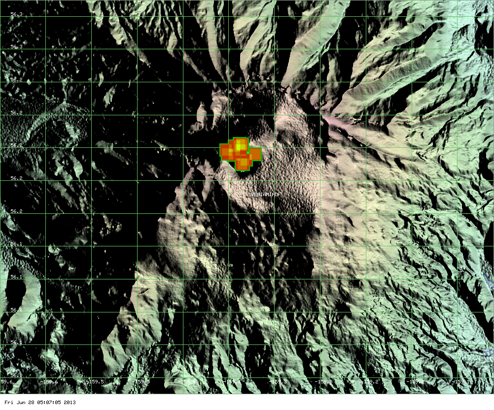
Image by MODIS showing the hot spot of Veniaminof volcano and the area of fresh lava flows on June 28, 2013 (ModVolc, Univ. Hawaii)
Geologic summary: Massive Veniaminof volcano, one of the highest and largest volcanoes on the Alaska Peninsula, is truncated by a steep-walled, 8 x 11 km, glacier-filled caldera that formed around 3,700 years ago. The caldera rim is up to 520 m high on the N, is deeply notched on the W by Cone Glacier, and is covered by an ice sheet on the S. Post-caldera vents are located along a NW-SE zone bisecting the caldera that extends 55 km from near the Bering Sea coast, across the caldera, and down the Pacific flank. Historical eruptions probably all originated from the westernmost and most prominent of two intra-caldera cones, which reaches an elevation of 2,156 m and rises about 300 m above the surrounding icefield. The other cone is larger, and has a summit crater or caldera that may reach 2.5 km in diameter, but is more subdued and barely rises above the glacier surface.
Ongoing activity
FUEGO, Guatemala
14.473°N, 90.880°W; summit elev. 3763 m
INSIVUMEH reported that explosions from Fuego on 26 June generated shock waves and ash plumes that rose 400 m and drifted SW. On 27 June explosions produced ash plumes that rose 550 m and drifted 10 km. Shock waves vibrated structures in areas including Sangre de Cristo (8 km WSW), Panimaché (8 km SW), and Morelia (9 km SW). Lahars descended the Las Lajas and El Jute drainages (SE), carrying blocks up to 1.5 m in diameter as well as tree trucks and branches.
On 28 June Vulcanian explosions produced shockwaves felt by local populations within 15 km. Explosions also generated ash plumes that rose 100-200 m and drifted W, and ejected incandescent tephra 150 m above the crater. Ashfall was reported in Panimaché, Morelia, and Sangre de Cristo. A lava flow was active on the flank. During 29 June-2 July explosions generated ash plumes that rose 500-600 m and mostly drifted W and NW.
.jpg)
Volcanic activity at Fuego volcano, Guatemala on June 28, 2013 (Credit:INSIVUMEH-OVFGO-IVM-FUND)
Geologic summary: Volcán Fuego, one of Central America's most active volcanoes, is one of three large stratovolcanoes overlooking Guatemala's former capital, Antigua. The scarp of an older edifice, Meseta, lies between 3,763-m-high Fuego and its twin volcano to the N, Acatenango. Construction of Meseta volcano continued until the late Pleistocene or early Holocene, after which growth of the modern Fuego volcano continued the southward migration of volcanism that began at Acatenango. Frequent vigorous historical eruptions have been recorded at Fuego since the onset of the Spanish era in 1524, and have produced major ashfalls, along with occasional pyroclastic flows and lava flows. The last major explosive eruption from Fuego took place in 1974, producing spectacular pyroclastic flows visible from Antigua.
KILAUEA, Hawaii (USA)
19.421°N, 155.287°W; summit elev. 1222 m
During 26 June-2 July HVO reported that the circulating lava lake occasionally rose and fell in the deep pit within Kilauea's Halema'uma'u Crater but remained about 40-45 m below the crater floor. The plume from the vent continued to deposit variable amounts of ash, spatter, and Pele's hair onto nearby areas.
At Pu'u 'O'o Crater, glow emanated from three spatter cones and a small lava pond on the E part of the crater floor. The Kahauale’a 2 lava flows (formerly known as the Kahauale’a II lava flow), fed by the NE spatter cone, were active as far N as 2.6 km and as far NNW as 1.9 km, and burned forest in both areas. At about 2230 on 18 June breakouts from the Kahauale’a 2 lava tube, near the NE spatter cone and high on the NE flank of Pu'u 'O'o cone, produced lava flows that traveled N down the flank. On 27 June the Kahauale’a 2 flow field was mapped and found to be 40 percent larger than when it was last mapped on 11 June.
Peace Day activity, fed by lava tubes extending from Pu'u 'O'o, consisted of some breakout activity on the pali and coastal plain, and ocean entries at locations inside and outside the National Park boundary.
Geologic summary: Kilauea, one of five coalescing volcanoes that comprise the island of Hawaii, is one of the world's most active volcanoes. Eruptions at Kilauea originate primarily from the summit caldera or along one of the lengthy E and SW rift zones that extend from the caldera to the sea. About 90% of the surface of Kilauea is formed of lava flows less than about 1,100 years old; 70% of the volcano's surface is younger than 600 years. A long-term eruption from the East rift zone that began in 1983 has produced lava flows covering more than 100 sq km, destroying nearly 200 houses and adding new coastline to the island.
KIZIMEN, Eastern Kamchatka (Russia)
55.130°N, 160.32°E; summit elev. 2376 m
KVERT reported that during 21-28 June moderate seismic activity continued at Kizimen. Video and satellite data showed that lava continued to extrude from the summit, producing incandescence, strong gas-and-steam activity, and hot avalanches on the W and E flanks. A thermal anomaly was detected in satellite images during 21-23 June; cloud cover prevented views of the volcano on the other days. The Aviation Color Code remained at Orange.
Geologic summary: Kizimen is an isolated, conical stratovolcano that is morphologically similar to Mount St. Helens prior to its 1980 eruption. The summit of Kizimen consists of overlapping lava domes, and blocky lava flows descend the flanks of the volcano, which is the westernmost of a volcanic chain north of Kronotsky volcano. The 2,376-m-high Kizimen was formed during four eruptive cycles beginning about 12,000 years ago and lasting 2,000-3,500 years. The largest eruptions took place about 10,000 and 8300-8400 years ago, and three periods of longterm lava-dome growth have occurred. The latest eruptive cycle began about 3,000 years ago with a large explosion and was followed by lava-dome growth lasting intermittently about 1,000 years. An explosive eruption about 1,100 years ago produced a lateral blast and created a 1.0 x 0.7 km wide crater breached to the NE, inside which a small lava dome (the fourth at Kizimen) has grown. A single explosive eruption, during 1927-28, has been recorded in historical time.
PACAYA, Guatemala
14.381°N, 90.601°W; summit elev. 2552 m
INSIVUMEH reported that blue-colored emissions from Pacaya were visible drifting SW and W at low altitudes on 26 June. Strombolian activity was observed from MacKenney cone the following day; weak-to-moderate explosions ejected small amounts of tephra 8 m above the crater that were then deposited on the W flank. Audible explosions were noted up to 5 km away. Incandescence was visible at night on 27 June. White fumarolic plumes rose 300 m above the cone on 28 and 30 June; white and blue fumarolic plumes drifted SW during 1-2 July. A recent investigation of MacKenney cone determined that a 15 m high cone had been the source of recent explosive activity.
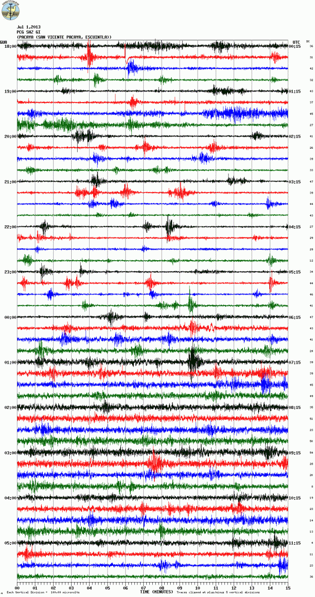
Seismic signal from Pacaya volcano, Guatemala on July 1, 2013 (Credit: PCG station, INSIVUMEH)
Geologic summary: Eruptions from Pacaya, one of Guatemala's most active volcanoes, are frequently visible from Guatemala City, the nation's capital. Pacaya is a complex volcano constructed on the southern rim of the 14 x 16 km Pleistocene Amatitlan caldera. A cluster of dacitic lava domes occupies the caldera floor. The Pacaya massif includes the Cerro Grande lava dome and a younger volcano to the SW. Collapse of Pacaya volcano about 1,100 years ago produced a debris-avalanche deposit that extends 25 km onto the Pacific coastal plain and left an arcuate somma rim inside which the modern Pacaya volcano (MacKenney cone) grew. During the past several decades, activity at Pacaya has consisted of frequent Strombolian eruptions with intermittent lava flow extrusion on the flanks of MacKenney cone, punctuated by occasional larger explosive eruptions.
SAKURA-JIMA, Kyushu
31.585°N, 130.657°E; summit elev. 1117 m
JMA reported that during 25-28 June Sakura-jima's Showa Crater had four explosions, ejecting tephra that fell at most 1.3 km from the crater. Crater incandescence was occasionally detected at night. Based on information from JMA, the Tokyo VAAC reported that on 26 June explosions were detected. Explosions on 1 July generated plumes that rose over 1.2 km (4,000 ft) a.s.l.
Geologic summary: Sakura-jima, one of Japan's most active volcanoes, is a post-caldera cone of the Aira caldera at the northern half of Kagoshima Bay. Eruption of the voluminous Ito pyroclastic flow was associated with the formation of the 17 x 23-km-wide Aira caldera about 22,000 years ago. The construction of Sakura-jima began about 13,000 years ago and built an island that was finally joined to the Osumi Peninsula during the major explosive and effusive eruption of 1914. Activity at the Kita-dake summit cone ended about 4,850 years ago, after which eruptions took place at Minami-dake. Frequent historical eruptions, recorded since the 8th century, have deposited ash on Kagoshima, one of Kyushu's largest cities, located across Kagoshima Bay only 8 km from the summit. The largest historical eruption took place during 1471-76.
SANTA MARIA, Guatemala
14.756°N, 91.552°W; summit elev. 3772 m
During 26 June-2 July, INSIVUMEH reported that ash plumes frequently rose from Santa María's Santiaguito lava-dome complex. Explosions during 26-28 June generated ash plumes that rose at most 900 m and drifted SW; ashfall was reported in Monte Claro (S) and Finca La Florida (5 km S) during 27-28 June. Avalanches originated from the lava flow on the S flank and from the SW lava dome, and produced pyroclastic flows on 27 June. An explosion at dawn on 28 June produced rumbling and degassing noises. Four moderate explosions during the morning of 30 June generated ash plumes that rose as high as 1 km and drifted S and SE. Rockfalls occurred on the flanks, and ash fell in San José, La Quina, and the region of Calahuaché. Explosions during 1-2 July generated incandescent avalanches from the S dome; a white plume rose 300 m above the crater. Gray plumes rose 400 m and drifted N.
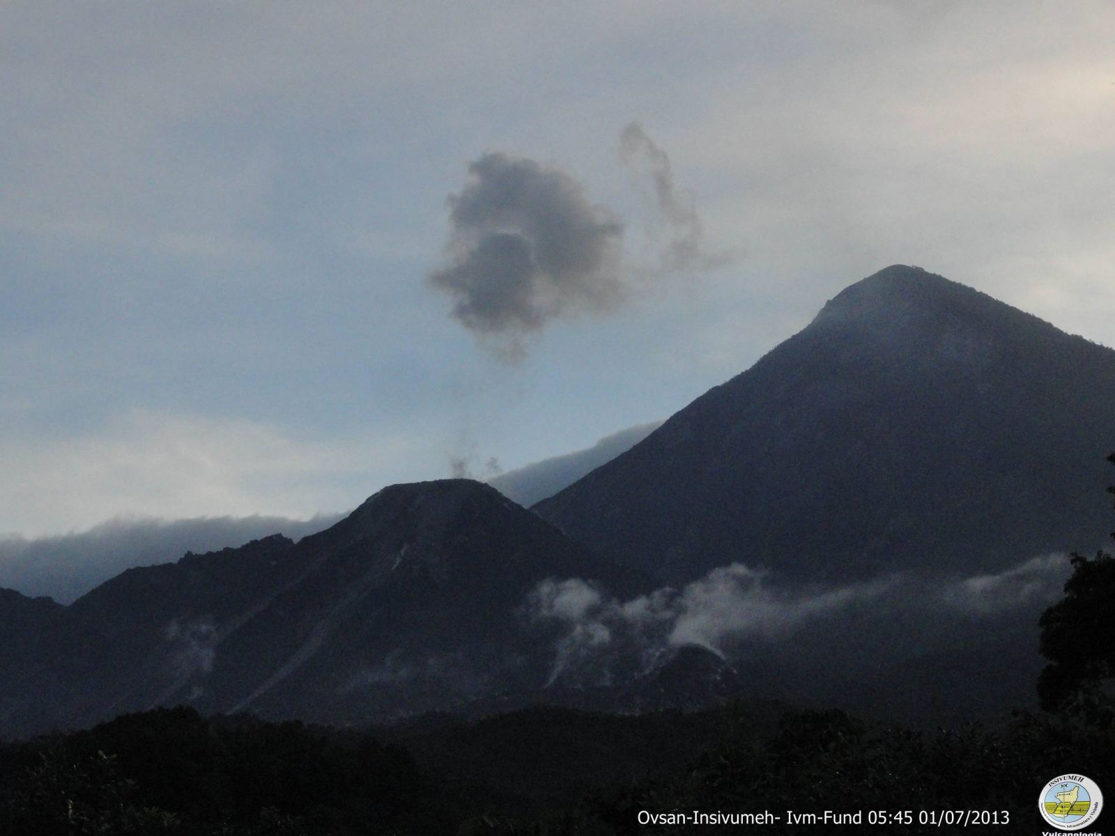
Eruption at Santiaguito volcano, Guatemala on July 1, 2013 (Credit: OVSAN-INSIVUMEH-IVM-FUND)
Geologic summary: Symmetrical, forest-covered Santa María volcano is one of a chain of large stratovolcanoes that rises dramatically above the Pacific coastal plain of Guatemala. The stratovolcano has a sharp-topped, conical profile that is cut on the SW flank by a large, 1-km-wide crater, which formed during a catastrophic eruption in 1902 and extends from just below the summit to the lower flank. The renowned Plinian eruption of 1902 followed a long repose period and devastated much of SW Guatemala. The large dacitic Santiaguito lava-dome complex has been growing at the base of the 1902 crater since 1922. Compound dome growth at Santiaguito has occurred episodically from four westward-younging vents, accompanied by almost continuous minor explosions and periodic lava extrusion, larger explosions, pyroclastic flows, and lahars.
TOLBACHIK, Central Kamchatka (Russia)
55.830°N, 160.330°E; summit elev. 3682 m
KVERT reported that the S fissure along the W side of Tolbachinsky Dol, a lava plateau on the SW side of Tolbachik, continued to produce very fluid lava flows during 21-28 June that traveled to the W, S, and E sides of the plateau. Cinder cones continued to grow along the S fissure and weak gas-and-steam plumes were observed. A large thermal anomaly on the N part of Tolbachinsky Dol was visible daily in satellite imagery. The Aviation Color Code remained at Orange.
Geologic summary: The massive Tolbachik basaltic volcano is located at the southern end of the dominantly andesitic Kliuchevskaya volcano group. The Tolbachik massif is composed of two overlapping, but morphologically dissimilar volcanoes. The flat-topped Plosky Tolbachik shield volcano with its nested Holocene Hawaiian-type calderas up to 3 km in diameter is located east of the older and higher sharp-topped Ostry Tolbachik stratovolcano. The summit caldera at Plosky Tolbachik was formed in association with major lava effusion about 6500 years ago and simultaneously with a major southward-directed sector collapse of Ostry Tolbachik volcano. Lengthy rift zones extending NE and SSW of the volcano have erupted voluminous basaltic lava flows during the Holocene, with activity during the past two thousand years being confined to the narrow axial zone of the rifts. The 1975-76 eruption originating from the SSW-flank fissure system and the summit was the largest historical basaltic eruption in Kamchatka.
Source: Global Volcanism Program
I actually counted over 60 active volcanoes worldwide, that's counting minor eruptions, right now. There are over 50 more volcanoes which are under watches…I posted a map that shows them all. Red means major eruption, oranges means minor eruption and yellow means, it might erupt.
Here is the Link again,
http://earthquakes.volcanodiscovery.com/
Way more volcanoes active than this. The world has gone active, not just this fault or that fault. I would watch the Pacific Northwest….there are volcanoes erupting all around the entire pacific except the West coast of the United States and Canada. here is a live view of the volcanic activity world wide….no way the eruptions stop at North America's Borders….WATCH..! http://earthquakes.volcanodiscovery.com/