
Active volcanoes in the world – May 29 – June 4, 2013
Image credit: TW
This week, 7 volcanoes were noticed to have new activity, whereas ongoing activity was reported for 13 volcanoes. This report covers active volcanoes in the world recorded from May 29 – June 4, 2013 based on Smithsonian/USGS criteria.
New activity/unrest: | Cleveland, Chuginadak Island | Copahue, Central Chile-Argentina border | Kikai, Japan | Mayon, Luzon | Pavlof, Alaska Peninsula | Popocatépetl, México | Turrialba, Costa Rica
Ongoing activity: | Bagana, Bougainville | Fuego, Guatemala | Karymsky, Eastern Kamchatka (Russia) | Kilauea, Hawaii (USA) | Kizimen, Eastern Kamchatka (Russia) | Pacaya, Guatemala | Poás, Costa Rica | Rabaul, New Britain | Reventador, Ecuador | Sakura-jima, Kyushu | Santa María, Guatemala | Shiveluch, Central Kamchatka (Russia) | Tolbachik, Central Kamchatka (Russia)
Global Volcanism Program and the US Geological Survey's Volcano Hazards Program. Updated by 2300 UTC every Wednesday, notices of volcanic activity posted on these pages are preliminary and subject to change as events are studied in more detail. This is not a comprehensive list of all of Earth's volcanoes erupting during the week, but rather a summary of activity at volcanoes that meet criteria discussed in detail in the "Criteria and Disclaimers" section. Carefully reviewed, detailed reports on various volcanoes are published monthly in the Bulletin of the Global Volcanism Network.
New activity/unrest
CLEVELAND, Chuginadak Island
52.825°N, 169.944°W; summit elev. 1730 m
On 4 June AVO reported that no explosions from Cleveland had been detected since 6 May, and there was no evidence of lava effusion since 13 May. Weakly elevated surface temperatures detected in recent clear-weather satellite images were consistent with cooling of a newly emplaced lava flow. AVO lowered the Volcanic Alert Level to Advisory and the Aviation Color Code to Yellow.
Geologic summary: Symmetrical Mount Cleveland stratovolcano is situated at the western end of the uninhabited dumbbell-shaped Chuginadak Island in the east-central Aleutians. The 1,730-m-high stratovolcano is the highest of the Islands of Four Mountains group and is one of the most active in the Aleutians. Numerous large lava flows descend its flanks. It is possible that some 18th to 19th century eruptions attributed to Carlisle (a volcano located across the Carlisle Pass Strait to the NW) should be ascribed to Cleveland. In 1944 Cleveland produced the only known fatality from an Aleutian eruption. Recent eruptions from Mt. Cleveland have been characterized by short-lived explosive ash emissions, at times accompanied by lava fountaining and lava flows down the flanks.
COPAHUE, Central Chile-Argentina border
37.85°S, 71.17°W; summit elev. 2997 m
OVDAS-SERNAGEOMIN reported that during 28-29 May seismicity at Copahue had decreased with respect to the previous 24-hour period; the majority of the signals were low-magnitude hybrid events, detected at an average rate of 127 per hour. Meteorological cloud cover prevented visual observations. During 29-30 May seismicity again decreased; earthquakes were detected at a rate of 40 events per hour. A camera near the volcano recorded a white plume that rose 100-200 m and drifted SE. The seismic network continued to record a downward trend during 30-31 May, with 120 events per hour detected during the night. By the time of the release of the report at 1700 on 31 May about 20 events per hour were being detected. Visual observations were again inhibited due to weather conditions. About 42 events per hour were recorded during 31 May-1 June, about 52 events per hour were detected during 1-2 June, and about 102 events per hour were detected during 2-3 June. A small plume rose 80 m above the crater during 2-3 June. ONEMI reported on 3 June that about 280 people, of 2,440 people, remained within the 25-km evacuation zone. That same day SERNAGEOMIN lowered the Alert Level to Orange.
Geologic summary: Volcán Copahue is an elongated composite cone constructed along the Chile-Argentina border within the 6.5 x 8.5 km wide Trapa-Trapa caldera that formed between 0.6 and 0.4 million years ago near the NW margin of the 20 x 15 km Pliocene Caviahue (Del Agrio) caldera. The eastern summit crater, part of a 2-km-long, ENE-WSW line of nine craters, contains a briny, acidic 300-m-wide crater lake (also referred to as El Agrio or Del Agrio) and displays intense fumarolic activity. Acidic hot springs occur below the eastern outlet of the crater lake, contributing to the acidity of the Río Agrio, and another geothermal zone is located within Caviahue caldera about 7 km NE of the summit. Infrequent mild-to-moderate explosive eruptions have been recorded at Copahue since the 18th century. Twentieth-century eruptions from the crater lake have ejected pyroclastic rocks and chilled liquid sulfur fragments.
KIKAI [SATSUMA-IWO-JIMA], Ryukyu Islands, Japan
30.78°N, 130.28°E; summit elev. 717 m
Based on information from JMA, the Tokyo VAAC reported that on 4 June an ash plume from Kikai drifted W.
Geologic summary: Kikai is a mostly submerged, 19-km-wide caldera near the northern end of the Ryukyu Islands south of Kyushu. Kikai was the source of one of the world's largest Holocene eruptions about 6,300 years ago. Pyroclastic flows traveled across the sea for a total distance of 100 km to southern Kyushu, and ashfall reached the northernmost Japanese island of Hokkaido. The eruption devastated southern and central Kyushu, which remained uninhabited for several centuries. Historical eruptions have occurred in the 20th century at or near Tokara-Iwo-Jima (also known as Satsuma-Iwo-jima), a small 3 x 6 km island forming part of the NW caldera rim. Showa-Iwo-jima (also known as Iwo-jima-Shinto), a small island 2 km E of Tokara-Iwo-jima, was formed during submarine eruptions in 1934 and 1935. Explosive eruptions have occurred during the past few decades from Iwo-dake, a rhyolitic lava dome at the eastern end of Tokara-Iwo-jima.
MAYON, Luzon
13.257°N, 123.685°E; summit elev. 2462 m
PHIVOLCS reported that during 30-31 May diffuse, short-lived, bluish, hydrogen sulfide emissions rose from Mayon, and incandescence from the crater was observed. Sulfur dioxide emissions fluctuated between 5 and 388 tonnes per day, remaining below the normal level of 500 tonnes per day. Seismicity was low, while a recently concluded ground deformation survey indicated slight inflation compared to February survey data. Based on the visual observations, and despite that most monitoring parameters remained within baseline levels, PHIVOLCS raised the Alert Level to 1 and reminded the public not to enter the 6-km-radius Permanent Danger Zone (PDZ).
On 1 June sulfur dioxide emissions were 131 tonnes per day. During 2-3 June the seismic network did not detect any volcanic earthquakes. Moderate emissions of white steam drifted WSW and SW, and weak crater incandescence was observed at night.
Geologic summary: Beautifully symmetrical Mayon volcano, which rises to 2,462 m above the Albay Gulf, is the Philippines' most active volcano. The structurally simple volcano has steep upper slopes that average 35-40° and is capped by a small summit crater. The historical eruptions of this basaltic-andesitic volcano date back to 1616 and range from Strombolian to basaltic Plinian. Eruptions occur predominately from the central conduit and have also produced lava flows that travel far down the flanks. Pyroclastic flows and mudflows have commonly swept down many of the approximately 40 ravines that radiate from the summit and have often devastated populated lowland areas. Mayon's most violent eruption, in 1814, killed more than 1,200 people and devastated several towns. Eruptions that began in February 2000 led PHIVOLCS to recommend on 23 February 2000 the evacuation of people within a radius of 7 km from the summit in the SE and within a 6 km radius for the rest of the volcano.
PAVLOF, Alaska Peninsula
55.42°N, 161.887°W; summit elev. 2519 m
AVO reported that ash emissions at Pavlof began at approximately 1100 on 4 June as observed in satellite images and by pilots. Satellite images showed an ash cloud drifting SE, and pilots estimated that the cloud was at an altitude of 5.8 km (19,000 ft) a.s.l. Weak seismicity that began at 1057 accompanied the emissions, and then continued. The Volcanic Alert Level was increased to Watch and the Aviation Color Code was increased Orange.
Geologic summary: The most active volcano of the Aleutian arc, Pavlof is a 2519-m-high Holocene stratovolcano that was constructed along a line of vents extending NE from the Emmons Lake caldera. Pavlof and its twin volcano to the NE, 2142-m-high Pavlof Sister, form a dramatic pair of symmetrical, glacier-covered stratovolcanoes that tower above Pavlof and Volcano bays. A third cone, Little Pavolf, is a smaller volcano on the SW flank of Pavlof volcano, near the rim of Emmons Lake caldera. Unlike Pavlof Sister, Pavlof has been frequently active in historical time, typically producing strombolian to vulcanian explosive eruptions from the summit vents and occasional lava flows. The active vents lie near the summit on the north and east sides. The largest historical eruption of Pavlof took place in 1911, at the end of a 5-year-long eruptive episode; a fissure opened on the northern flank of the volcano, ejecting large blocks and issuing lava flows.
POPOCATEPETL, México
19.023°N, 98.622°W; summit elev. 5426 m
CENAPRED reported that during 29 May-4 June seismicity at Popocatépetl indicated continuing gas-and-steam emissions that contained variable amounts of ash; cloud cover often prevented visual confirmation. Incandescence from the crater was often observed at night. On most days steam-and-gas plumes were observed drifting SW and SSW. Some periods of high-frequency and low-amplitude tremor were detected on 31 May and 1 June. During the early morning on 3 June a continuous plume of steam and ash was observed drifting SW. Later that day an ash plume rose 1 km on 3 June. The Alert Level remained at Yellow, Phase Three.

Ash emission from Popocatépel on June 3, 2013 (Credit:Tlamacas/CENAPRED)
Geologic summary: Popocatépetl, whose name is the Aztec word for smoking mountain, towers to 5,426 m 70 km SE of Mexico City and is North America's second-highest volcano. Frequent historical eruptions have been recorded since the beginning of the Spanish colonial era. A small eruption on 21 December 1994 ended five decades of quiescence. Since 1996 small lava domes have incrementally been constructed within the summit crater and destroyed by explosive eruptions. Intermittent small-to-moderate gas-and-ash eruptions have continued, occasionally producing ashfall in neighboring towns and villages.
TURRIALBA, Costa Rica
10.025°N, 83.767°W; summit elev. 3340 m
OVSICORI-UNA reported that on 29 May a pilot flying past Turrialba about 40 km away observed a blackish plume. Officials from the Parque Nacional Volcán Turrialba observed a gas plume that was slightly darker than usual between 0730 and 0745; seismic records showed no abnormal activity at those times or during the previous 48 hours. In addition, web camera images showed no noticeable ash emissions since 23 May. Gas plumes over 750 degrees Celsius were emitted from Boca 2010 (on the W wall) and Boca 2012 (on the E wall). The plume from Boca 2010 was whiter than the plume emitted from Boca 2012, mainly due to the difference in the ratio of magmatic gases and aerosols, and no ash.
On 4 June slight ashfall was reported in Pacayas and San Pablo in Oreamuno de Cartago (25 km SW). An observer in the National Park noted that between 1400 and 1500 gas emissions were slightly stronger and also grayish.
Geologic summary: Turrialba, the easternmost of Costa Rica's Holocene volcanoes, is a large vegetated basaltic-to-dacitic stratovolcano located across a broad saddle NE of Irazú volcano overlooking the city of Cartago. The massive 3340-m-high Turrialba is exceeded in height only by Irazú, covers an area of 500 sq km, and is one of Costa Rica's most voluminous volcanoes. Three well-defined craters occur at the upper SW end of a broad 800 x 2200 m wide summit depression that is breached to the NE. Most activity at Turrialba originated from the summit vent complex, but two pyroclastic cones are located on the SW flank. Five major explosive eruptions have occurred at Turrialba during the past 3500 years. Turrialba has been quiescent since a series of explosive eruptions during the 19th century that were sometimes accompanied by pyroclastic flows. Fumarolic activity continues at the central and SW summit craters.
Ongoing activity
BAGANA, Bougainville
6.140°S, 155.195°E; summit elev. 1750 m
Based on analyses of satellite imagery and wind data, the Darwin VAAC reported that on 4 June an ash plume from Bagana rose to an altitude of 2.4 km (8,000 ft) a.s.l. and drifted over 35 km W.
Geologic summary: Bagana volcano, occupying a remote portion of central Bougainville Island, is one of Melanesia's youngest and most active volcanoes. Bagana is a massive symmetrical lava cone largely constructed by an accumulation of viscous andesitic lava flows. The entire lava cone could have been constructed in about 300 years at its present rate of lava production. Eruptive activity at Bagana is characterized by non-explosive effusion of viscous lava that maintains a small lava dome in the summit crater, although explosive activity occasionally producing pyroclastic flows also occurs. Lava flows form dramatic, freshly preserved tongue-shaped lobes up to 50-m-thick with prominent levees that descend the volcano's flanks on all sides.
FUEGO, Guatemala
14.473°N, 90.880°W; summit elev. 3763 m
INSIVUMEH reported that rumbling and sounds resembling jet engines were heard from Fuego during 28-30 May; cloud cover often inhibited visual observations of the crater. On 29 May a lahar carrying blocks up to 50 cm in diameter traveled SE down the Las Lajas and El Jute drainages. On 30 May a plume was observed rising 200 m above the crater and drifting S. During 1-2 and 4 June explosions generated ash plumes that rose at most 800 m and drifted 5-8 km W and NW. Incandescent material was ejected 100 m above the crater and generated avalanches. On 2 June heavy rain caused lahars that traveled down the Ceniza drainage, carrying trees, logs, and blocks. On 3 June diffuse white plumes rose 200 m.
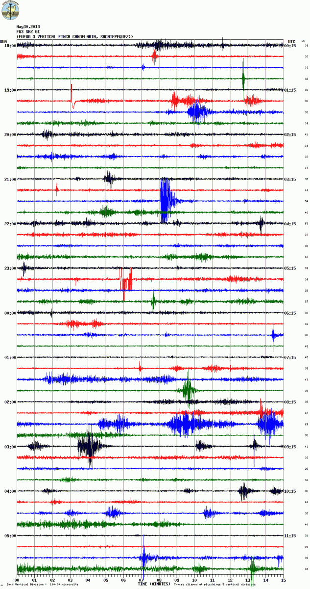
Seismic signal from Fuego volcano on May 30, 2013 (Credit: FG3 station, INSIVUMEH)
Geologic summary: Volcán Fuego, one of Central America's most active volcanoes, is one of three large stratovolcanoes overlooking Guatemala's former capital, Antigua. The scarp of an older edifice, Meseta, lies between 3,763-m-high Fuego and its twin volcano to the N, Acatenango. Construction of Meseta volcano continued until the late Pleistocene or early Holocene, after which growth of the modern Fuego volcano continued the southward migration of volcanism that began at Acatenango. Frequent vigorous historical eruptions have been recorded at Fuego since the onset of the Spanish era in 1524, and have produced major ashfalls, along with occasional pyroclastic flows and lava flows. The last major explosive eruption from Fuego took place in 1974, producing spectacular pyroclastic flows visible from Antigua.
KARYMSKY, Eastern Kamchatka (Russia)
54.05°N, 159.45°E; summit elev. 1536 m
KVERT reported that weak seismic activity was detected at Karymsky during 25-26 May; technical problems prevented seismic data collection on the other days during 24-31 May. Satellite data showed a thermal anomaly on the volcano on 25 and 28 May, during periods of clearer weather conditions. The Aviation Color Code remained at Orange.
Geologic summary: Karymsky, the most active volcano of Kamchatka's eastern volcanic zone, is a symmetrical stratovolcano constructed within a 5-km-wide caldera that formed about 7,600-7,700 radiocarbon years ago. Construction of the Karymsky stratovolcano began about 2,000 years later. The latest eruptive period began about 500 years ago, following a 2,300-year quiescence. Much of the cone is mantled by lava flows less than 200 years old. Historical eruptions have been Vulcanian or Vulcanian-Strombolian with moderate explosive activity and occasional lava flows from the summit crater. Most seismicity preceding Karymsky eruptions has originated beneath Akademia Nauk caldera, which is located immediately S of Karymsky volcano and erupted simultaneously with Karymsky in 1996.
KILAUEA, Hawaii (USA)
19.421°N, 155.287°W; summit elev. 1222 m
During 29 May-4 June HVO reported that the circulating lava lake occasionally rose and fell in the deep pit within Kilauea's Halema'uma'u Crater. The plume from the vent continued to deposit variable amounts of ash, spatter, and Pele's hair onto nearby areas.
At Pu'u 'O'o Crater, glow emanated from three spatter cones and a small lava pond on the E part of the crater floor. The Kahauale’a II lava flows traveled N from the base of Pu'u 'O'o cone. The most distal front of the flow was 1.8 km from its source at a spatter cone on the NE edge of Pu'u 'O'o's crater floor. At 0740 on 26 May lava began to spill from the N side of the NE spatter cone, feeding a new breakout on the N flank of Pu'u 'O'o.
Peace Day activity, fed by lava tubes extending from Pu'u 'O'o, consisted of some breakout activity on the pali and coastal plain, but mainly flows entering the ocean at locations inside and outside the National Park boundary.
Geologic summary: Kilauea, one of five coalescing volcanoes that comprise the island of Hawaii, is one of the world's most active volcanoes. Eruptions at Kilauea originate primarily from the summit caldera or along one of the lengthy E and SW rift zones that extend from the caldera to the sea. About 90% of the surface of Kilauea is formed of lava flows less than about 1,100 years old; 70% of the volcano's surface is younger than 600 years. A long-term eruption from the East rift zone that began in 1983 has produced lava flows covering more than 100 sq km, destroying nearly 200 houses and adding new coastline to the island.
KIZIMEN, Eastern Kamchatka (Russia)
55.130°N, 160.32°E; summit elev. 2376 m
KVERT reported that during 24-31 May moderate seismic activity continued at Kizimen. Video and satellite data showed that lava continued to extrude from the summit, producing incandescence, strong gas-and-steam activity, and hot avalanches on the W and E flanks. A thermal anomaly was detected daily in satellite images. The Aviation Color Code remained at Orange.
Geologic summary: Kizimen is an isolated, conical stratovolcano that is morphologically similar to Mount St. Helens prior to its 1980 eruption. The summit of Kizimen consists of overlapping lava domes, and blocky lava flows descend the flanks of the volcano, which is the westernmost of a volcanic chain north of Kronotsky volcano. The 2,376-m-high Kizimen was formed during four eruptive cycles beginning about 12,000 years ago and lasting 2,000-3,500 years. The largest eruptions took place about 10,000 and 8300-8400 years ago, and three periods of longterm lava-dome growth have occurred. The latest eruptive cycle began about 3,000 years ago with a large explosion and was followed by lava-dome growth lasting intermittently about 1,000 years. An explosive eruption about 1,100 years ago produced a lateral blast and created a 1.0 x 0.7 km wide crater breached to the NE, inside which a small lava dome (the fourth at Kizimen) has grown. A single explosive eruption, during 1927-28, has been recorded in historical time.
PACAYA, Guatemala
14.381°N, 90.601°W; summit elev. 2552 m
INSIVUMEH reported that incandescence from Pacaya's crater was observed late at night on 28 May. Weather conditions prevented observations the next day. On 30 May a small effusive eruption occurred for about two hours. A small explosion ejected ash and lapilli 200 m above the crater that was then deposited within 400 m of the crater. Inclement weather prevented observations the rest of the day; however, the seismic network detected tremor and weak explosions.
Geologic summary: Eruptions from Pacaya, one of Guatemala's most active volcanoes, are frequently visible from Guatemala City, the nation's capital. Pacaya is a complex volcano constructed on the southern rim of the 14 x 16 km Pleistocene Amatitlan caldera. A cluster of dacitic lava domes occupies the caldera floor. The Pacaya massif includes the Cerro Grande lava dome and a younger volcano to the SW. Collapse of Pacaya volcano about 1,100 years ago produced a debris-avalanche deposit that extends 25 km onto the Pacific coastal plain and left an arcuate somma rim inside which the modern Pacaya volcano (MacKenney cone) grew. During the past several decades, activity at Pacaya has consisted of frequent Strombolian eruptions with intermittent lava flow extrusion on the flanks of MacKenney cone, punctuated by occasional larger explosive eruptions.
POAS, Costa Rica
10.20°N, 84.233°W; summit elev. 2708 m
OVSICORI-UNA reported that during May temperatures of the cryptodome at Poás were high enough to produce nighttime incandescence. Maximum temperatures of 575 and 450 degrees Celsius were recorded on 8 and 30 May, respectively. Activity of the lake was very similar to that reported for May 2012, characterized by sporadic phreatic eruptions and a slow decline in the water level. On 8 May 2013 the water level was 0.5 m below the level measured on 8 May 2012. Phreatic eruptions occurred at 1100 on 1 May, at 1700 on 8 May, and at 1125 and 1510 on 28 May. Fumarolic activity was variable.
During the early morning hours on 2 and 3 June, residents reported a gas plume rising 1 km above the crater floor. OVSICORI-UNA noted that recent plumes were high-temperature (450-575 degrees Celsius) and rich in sulfur dioxide, giving the plumes a bluish-white color.
Geologic summary: The broad, well-vegetated edifice of Poás, one of the most active volcanoes of Costa Rica, contains three craters along a N-S line. The frequently visited multi-hued summit crater lakes of the basaltic-to-dacitic volcano, which is one of Costa Rica's most prominent natural landmarks, are easily accessible by vehicle from the nearby capital city of San José. A N-S-trending fissure cutting the 2,708-m-high complex stratovolcano extends to the lower northern flank, where it has produced the Congo stratovolcano and several lake-filled maars. The southernmost of the two summit crater lakes, Botos, is cold and clear and last erupted about 7,500 years ago. The more prominent geothermally heated northern lake, Laguna Caliente, is one of the world's most acidic natural lakes, with a pH of near zero. It has been the site of frequent phreatic and phreatomagmatic eruptions since the first historical eruption was reported in 1828. Poás eruptions often include geyser-like ejection of crater-lake water.
RABAUL, New Britain
4.271°S, 152.203°E; summit elev. 688 m
RVO reported that during 17-31 May white vapor plumes sometimes containing fine ash rose at most 800 m from Rabaul caldera's Tavurvur cone and drifted NW and SE. Ashfall was reported in areas downwind including Rabaul town (3-5 km NW). Roaring and rumbling noises also continued. Seismicity was low, and slight inflation was detected at a station on Matupit Island (2 km W).
Geologic summary: The low-lying Rabaul caldera on the tip of the Gazelle Peninsula at the NE end of New Britain forms a broad sheltered harbor. The outer flanks of the 688-m-high asymmetrical pyroclastic shield volcano are formed by thick pyroclastic-flow deposits. The 8 x 14 km caldera is widely breached on the E, where its floor is flooded by Blanche Bay. Two major Holocene caldera-forming eruptions at Rabaul took place as recently as 3,500 and 1,400 years ago. Three small stratovolcanoes lie outside the northern and NE caldera rims. Post-caldera eruptions built basaltic-to-dacitic pyroclastic cones on the caldera floor near the NE and western caldera walls. Several of these, including Vulcan cone, which was formed during a large eruption in 1878, have produced major explosive activity during historical time. A powerful explosive eruption in 1994 occurred simultaneously from Vulcan and Tavurvur volcanoes and forced the temporary abandonment of Rabaul city.
REVENTADOR, Ecuador
0.077°S, 77.656°W; summit elev. 3562 m
The Washington VAAC reported that on 1 June gas emissions from Reventador possibly contained diffuse ash. Ash was not detected in satellite images.
Geologic summary: Reventador is the most frequently active of a chain of Ecuadorian volcanoes in the Cordillera Real, well E of the principal volcanic axis. It is a forested stratovolcano that rises above the remote jungles of the western Amazon basin. A 3-km-wide caldera breached to the E was formed by edifice collapse and is partially filled by a young, unvegetated stratovolcano that rises about 1,300 m above the caldera floor. Reventador has been the source of numerous lava flows as well as explosive eruptions that were visible from Quito in historical time. Frequent lahars in this region of heavy rainfall have constructed a debris plain on the eastern floor of the caldera.
SAKURA-JIMA, Kyushu
31.585°N, 130.657°E; summit elev. 1117 m
JMA reported that during 27-31 May Sakura-jima's Showa Crater had four explosions, ejecting tephra that fell at most 1.3 km from the crater. Crater incandescence was occasionally detected at night. A small pyroclastic flow traveled 700 m down the E flank. A pyroclastic flow also occurred in the crater. Based on information from JMA, the Tokyo VAAC reported that on 30 May explosions produced plumes that rose to altitudes of 2.1-2.4 km (7,000-8,000 ft) a.s.l. and drifted E. An explosion was detected on 1 June, and on 2 June an explosion produced an ash plume that rose 1.5 km (5,000 ft) a.s.l.
Geologic summary: Sakura-jima, one of Japan's most active volcanoes, is a post-caldera cone of the Aira caldera at the northern half of Kagoshima Bay. Eruption of the voluminous Ito pyroclastic flow was associated with the formation of the 17 x 23-km-wide Aira caldera about 22,000 years ago. The construction of Sakura-jima began about 13,000 years ago and built an island that was finally joined to the Osumi Peninsula during the major explosive and effusive eruption of 1914. Activity at the Kita-dake summit cone ended about 4,850 years ago, after which eruptions took place at Minami-dake. Frequent historical eruptions, recorded since the 8th century, have deposited ash on Kagoshima, one of Kyushu's largest cities, located across Kagoshima Bay only 8 km from the summit. The largest historical eruption took place during 1471-76.
SANTA MARIA, Guatemala
14.756°N, 91.552°W; summit elev. 3772 m
INSIVUMEH reported that on 29 May white gas plumes rose 200 m above Santa María's Santiaguito lava-dome complex and drifted W. Avalanches occurred on the NE and S flanks of the dome. An explosion on 30 May generated an ash plume that rose 500 m; ashfall was reported in Calahuaché village. On 1 June a weak lahar descended the Nima I drainage on the SE flank, and on 2 June dense white plumes rose from the dome. At 1855 on 4 June a lahar again descended the Nima I drainage and was about 40 m wide and 2.5 m thick.
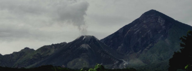
Webcam image of Santiaguito volcano captured on June 4, 2013 (Credit: OVSAN/INSIVUMEH/IVM/FUND)
Geologic summary: Symmetrical, forest-covered Santa María volcano is one of a chain of large stratovolcanoes that rises dramatically above the Pacific coastal plain of Guatemala. The stratovolcano has a sharp-topped, conical profile that is cut on the SW flank by a large, 1-km-wide crater, which formed during a catastrophic eruption in 1902 and extends from just below the summit to the lower flank. The renowned Plinian eruption of 1902 followed a long repose period and devastated much of SW Guatemala. The large dacitic Santiaguito lava-dome complex has been growing at the base of the 1902 crater since 1922. Compound dome growth at Santiaguito has occurred episodically from four westward-younging vents, accompanied by almost continuous minor explosions and periodic lava extrusion, larger explosions, pyroclastic flows, and lahars.
SHIVELUCH, Central Kamchatka (Russia)
56.653°N, 161.360°E; summit elev. 3283 m
Based on visual observations and analyses of satellite data, KVERT reported that during 24-31 May a viscous lava flow effused on the N flank of Shiveluch's lava dome, accompanied by hot avalanches, incandescence, and fumarolic activity. Satellite imagery showed a daily thermal anomaly on the lava dome. The Aviation Color Code remained at Orange.
Geologic summary: The high, isolated massif of Shiveluch volcano (also spelled Sheveluch) rises above the lowlands NNE of the Kliuchevskaya volcano group and forms one of Kamchatka's largest and most active volcanoes. The currently active Molodoy Shiveluch lava-dome complex was constructed during the Holocene within a large breached caldera formed by collapse of the massive late-Pleistocene Strary Shiveluch volcano. At least 60 large eruptions of Shiveluch have occurred during the Holocene, making it the most vigorous andesitic volcano of the Kuril-Kamchatka arc. Frequent collapses of lava-dome complexes, most recently in 1964, have produced large debris avalanches whose deposits cover much of the floor of the breached caldera. Intermittent explosive eruptions began in the 1990s from a new lava dome that began growing in 1980. The largest historical eruptions from Shiveluch occurred in 1854 and 1964.
TOLBACHIK, Central Kamchatka (Russia)
55.830°N, 160.330°E; summit elev. 3682 m
KVERT reported that the S fissure along the W side of Tolbachinsky Dol, a lava plateau on the SW side of Tolbachik, continued to produce very fluid lava flows during 24-31 May that traveled to the W, S, and E sides of the plateau. Cinder cones continued to grow along the S fissure and weak gas-and-steam plumes were observed. A large thermal anomaly on the N part of Tolbachinsky Dol was visible daily in satellite imagery. The Aviation Color Code remained at Orange.
Geologic summary: The massive Tolbachik basaltic volcano is located at the southern end of the dominantly andesitic Kliuchevskaya volcano group. The Tolbachik massif is composed of two overlapping, but morphologically dissimilar volcanoes. The flat-topped Plosky Tolbachik shield volcano with its nested Holocene Hawaiian-type calderas up to 3 km in diameter is located east of the older and higher sharp-topped Ostry Tolbachik stratovolcano. The summit caldera at Plosky Tolbachik was formed in association with major lava effusion about 6500 years ago and simultaneously with a major southward-directed sector collapse of Ostry Tolbachik volcano. Lengthy rift zones extending NE and SSW of the volcano have erupted voluminous basaltic lava flows during the Holocene, with activity during the past two thousand years being confined to the narrow axial zone of the rifts. The 1975-76 eruption originating from the SSW-flank fissure system and the summit was the largest historical basaltic eruption in Kamchatka.
Source: Global Volcanism Program
The reason for all this activity is the continued highly unusual planetary alignment of our solar system. I have looked at past years with strong volcanic eruptions and devastating quakes and there always is an overload of Sun and planets be it conjunction or opposition. The space probes of Jupiter and Saturn have shown that gravity waves cause there moons to be extra active in there volcanic activity. The experts tell me that gravity is to week a force to do this to earth but why then when we get these overloads of planetary alignment do we get so much activity? These last months have been a period of much activity and strong planetary alignment. I say there is a connection and that we should expect more activity with the chance for super eruptions at a high level.