
Tropical Cyclone Mahasen targets India, Bangladesh, Myanmar
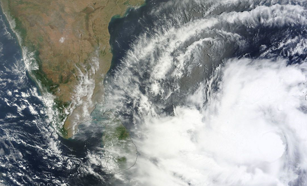
Featured image: MODIS satellite image of TC Mahasen on May 11, 2013 (Credit: LANCE/MODIS/Worldview)
Tropical Cyclone Mahasen (TC 01B) is getting better organized. Winds are predicted to increase to hurricane force as the system moves further northward into the Bay of Bengal. TC Mahasen is now located east-northeast of Sri Lanka and is expected to impact areas from northeast India to Bangladesh and Myanmar.
According to latest report by Joint Typhoon Warning Center (JTWC), TC Mahasen is located approximately 721 nm southward of Calcutta, India. The system is moving north-northwestward at speed of 6 knots. Maximum sustainable winds are 55 knots with gusts up to 70 knots.
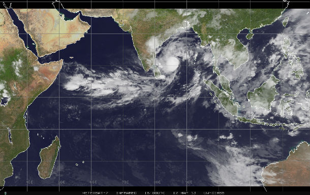
Indian Ocean IR satellite image of the system on May 12, 2013 (Credit: METEOSAT-7/CIMSS)
The cyclone is beginning to round the western edge of the subtropical ridge to the east. It is expected to slow down over the next 24 hours as it makes the turn before recurving northeastward on the poleward side of the ridge axis. TC Mahasen will gradually intensify as the vertical wind shear relaxes along the ridge axis. Additionally, the poleward outflow is expected to open up as the system becomes exposed to the prevailing westerlies.
Animated infrared satellite imagery shows the system has regained a central dense overcast feature that has, once again, obscured the low level circulation center. Upper level analysis indicates the system is 7 degrees south of the ridge axis in an area of moderate (20 knot) easterly vertical wind shear. However, the vertical wind shear is offset by robust westward outflow.
After the next 72 hours, TC Mahasen will gradually weaken as vertical wind shear increases before making landfall near Chittagong, Bangladesh. Land interaction will rapidly erode and dissipate the system.
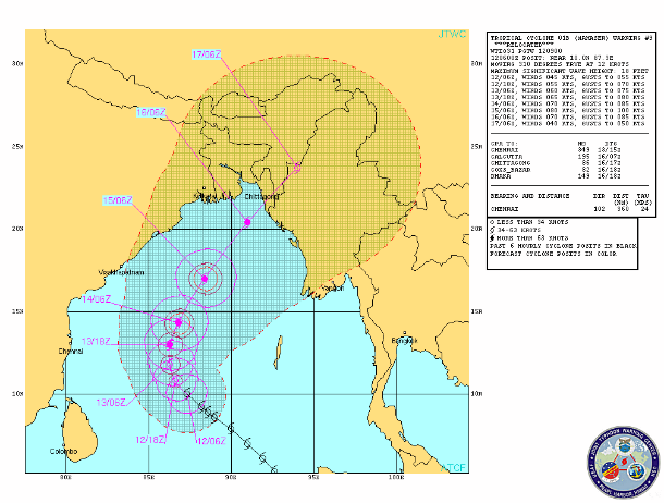
TC Mahasen forecast track (Source: JTWC)
According to Indian Meteorological Department (IMD), under the influence of this system, rainfall at many places with isolated heavy rainfall would occur over Andaman and Nicobar Islands during next 48 hours. Squally winds speed reaching 40-45 km/h gusting to 60 km/h would prevail along Andaman and Nicobar Islands during next 48 hours. Sea condition will be rough to very rough along and off Andaman and Nicobar Islands during this period.
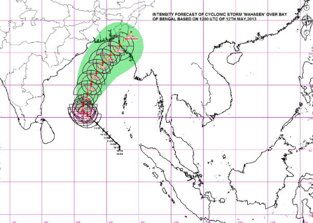
Cyclone wind intensity forecast map (Source: IMD)
Parts of Bangladesh and northeast India have received 6-12 inches of rainfall during the past week, so additional heavy rainfall from a tropical cyclone would likely produce widespread flooding and possible mudslides. Chittagong, coastal city of 2.5 million people in Bangladesh, received more than 15 inches of rain in the past 8 days.

The TRMM satellite flew almost directly above intensifying Tropical Cyclone Mahasen late on May 11, 2013. TRMM PR data found that the heaviest rainfall was falling at a rate of over 142 mm/h (~5.6 inches) in a band of powerful storms well to the southwest of Mahasen's center. (Credit: NASA/TRMM)
Tropical Cyclone Nargis devastated parts of Myanmar in 2008. The storm killed more than 100,000 people. Tropical Cyclone Bob in 1991 reportedly killed more than 100,000 people as well. TC Mahasen is not expected to be as powerful as either of these, however much damage can be expected.
.jpg)
Satellite Animations
- Storm-Centered Infrared (MTSAT; NOAA/SSD)
- Storm-Centered Infrared (Aviation Color Enhancement) (MTSAT; NOAA/SSD)
- Storm-Centered Water Vapor (MTSAT; NOAA/SSD)
- Storm-Centered Visible (MTSAT; NOAA/SSD)
- Storm-Centered Visible (Colorized) (MTSAT; NOAA/SSD)
- Meteosat 7 Infrared (Meteosat 7; CIMSS)
- Meteosat 7 Infrared (Color Background) (Meteosat 7; CIMSS)
- Meteosat 7 Infrared (NHC Color Enhancement) (Meteosat 7; CIMSS)
- Meteosat 7 Water Vapor (Meteosat 7; CIMSS)
- Meteosat 7 Water Vapor (Color Background) (Meteosat 7; CIMSS)
very good!!!!!!
a cool weather and even a news!!!!!!
Good News MAHASEN weakening and turn round.
Whats the recent update.
http://www.imd.gov.in/section/nhac/dynamic/cyclone.htm
http://www.usno.navy.mil/NOOC/nmfc-ph/RSS/jtwc/warnings/io0113web.txt
http://www.bmd.gov.bd/WarningDetails.php?WarningId=69