
Active volcanoes in the world: February 6 – February 12, 2013
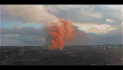
Image credit: Alan L - CC BY 2.0
This week, 9 volcanoes were noticed to have new activity, whereas ongoing activity was reported for 13 volcanoes. This report covers active volcanoes in the world recorded from February 6 – February 12, 2013 based on Smithsonian/USGS criteria.
New activity/unrest: | Aoba, Vanuatu (SW Pacific) | Cleveland, Chuginadak Island | Etna, Sicily (Italy) | Rabaul, New Britain | Rasshua, Kuril Islands (Russia) | Reventador, Ecuador | Soufrière Hills, Montserrat | Stromboli, Aeolian Islands (Italy) | White Island, New Zealand
Ongoing activity: | Bagana, Bougainville | Batu Tara, Komba Island (Indonesia) | Bezymianny, Central Kamchatka (Russia) | Chirpoi, Kuril Islands (Russia) | Karymsky, Eastern Kamchatka (Russia) | Kilauea, Hawaii (USA) | Kizimen, Eastern Kamchatka (Russia) | Manam, Northeast of New Guinea (SW Pacific) | Paluweh, Lesser Sunda Islands (Indonesia) | Sakura-jima, Kyushu | Santa María, Guatemala | Shiveluch, Central Kamchatka (Russia) | Tolbachik, Central Kamchatka (Russia)
The Weekly Volcanic Activity Report is a cooperative project between the Smithsonian’s Global Volcanism Program and the US Geological Survey’s Volcano Hazards Program. Updated by 2300 UTC every Wednesday, notices of volcanic activity posted on these pages are preliminary and subject to change as events are studied in more detail. This is not a comprehensive list of all of Earth’s volcanoes erupting during the week, but rather a summary of activity at volcanoes that meet criteria discussed in detail in the “Criteria and Disclaimers” section. Carefully reviewed, detailed reports on various volcanoes are published monthly in the Bulletin of the Global Volcanism Network.
New activity/unrest
AOBA, Vanuatu (SW Pacific)
15.40°S, 167.83°E; summit elev. 1496 m
According to the Vanuatu Geohazards Observatory, Ambanga villagers reported that minor activity at Aoba began in December 2012. The OMI instrument detected strong gas emissions on 18 and 25 January; the emissions continued at a lower level through 7 February. Field observations by the Geohazards team during 30 January-2 February confirmed that activity had significantly changed. Data retrieved from a monitoring station also confirmed ongoing activity. The Vanuatu Volcano Alert Level (VVAL) remained at 1 (on a scale of 0-4).
Geologic summary: Aoba, also known as Ambae, is a massive 2500 cu km basaltic shield volcano that is the most voluminous volcano of the New Hebrides archipelago. A pronounced NE-SW-trending rift zone dotted with scoriacones gives the 16 x 38 km island an elongated form. A broad pyroclastic cone containing three crater lakes is located at the summit of the Hawaiian-style shield volcano within the youngest of at least two nested calderas, the largest of which is 6 km in diameter. Post-caldera explosive eruptions formed the summit craters of Lake Voui (also spelled Vui) and Lake Manaro Ngoru about 360 years ago. A tuff cone was constructed within Lake Voui about 60 years later. The latest known flank eruption, about 300 years ago, destroyed the population of the Nduindui area near the western coast.
CLEVELAND, Chuginadak Island
52.825°N, 169.944°W; summit elev. 1730 m
On 6 February AVO reported that satellite imagery acquired on 30 January indicated that a lava dome had grown in Cleveland’s summit crater, prompting AVO to raise the Volcanic Alert Level to Watch and the Aviation Color Codeto Orange. The dome was about 100 m in diameter and may have begun forming as early as 24 January when elevated surface temperatures were observed in satellite images. The size and shape of the dome appeared to be unchanged based on satellite data acquired on 2 February. Elevated surface temperatures from the lava dome were detected during 5-6 and 8-11 February.
Geologic summary: Symmetrical Mount Cleveland stratovolcano is situated at the western end of the uninhabited dumbbell-shaped Chuginadak Island in the east-central Aleutians. The 1,730-m-high stratovolcano is the highest of the Islands of Four Mountains group and is one of the most active in the Aleutians. Numerous large lava flows descend its flanks. It is possible that some 18th to 19th century eruptions attributed to Carlisle (a volcano located across the Carlisle Pass Strait to the NW) should be ascribed to Cleveland. In 1944 Cleveland produced the only known fatality from an Aleutian eruption. Recent eruptions from Mt. Cleveland have been characterized by short-lived explosive ash emissions, at times accompanied by lava fountaining and lava flows down the flanks.
ETNA, Sicily (Italy)
37.734°N, 15.004°E; summit elev. 3330 m
Sezione di Catania – Osservatorio Etneo reported that during the days following the 2 February eruptive episode at Etna intermittent emissions of small quantities of ash were repeatedly observed from both the New Southeast Crater (NSEC) and Bocca Nuova Crater.
Volcanologists visited Etna on 5 February and observed the recent changes that had taken place at Bocca Nuova Crater, notably the growth of a pyroclastic cone surrounding the eruptive vent in the SE portion of the crater. This cone had grown at least 50-70 m, about halfway up the inner crater wall, and was leaning into the wall. The entire crater floor was covered with recent lava.
Later in the evening of 5 February a webcam recorded weak Strombolian activity at NSEC, which continued until daybreak the next day, and then became invisible due to deteriorating weather conditions. Seismic data showed an instantaneous increase of tremor at 1020; volcanic tremor amplitude rose to a peak within a few minutes after the start of the activity, and began to descend after less than one hour. People in the ski area on the NE flank of the volcano briefly saw a dense but ash-free gas plume rising from the summit.
After the episode on 6 February through most of 8 February sporadic ash emissions from NSEC were observed, although poor weather conditions often prevented observations. On the evening of 8 February weak glow from NSEC was intermittently visible. At 2100 a webcam recorded fluctuating glow from within Bocca Nuova which became more intense over the next 10 minutes. Around 2125 jets of incandescent lava were repeatedly seen rising above a thick blanket of clouds drifting over the summit area of Etna. Contemporaneously, the volcanic tremor amplitude rose sharply. After 2200 the volcanic tremor amplitude began to decrease, whereas the eruptive activity continued without showing signs of diminishing until about 30 minutes later. After 2230 on 8 February and during 9-10 cloud cover prevented observations. A brief ash emission was observed on 10 February.
Geologic summary: Mount Etna, towering above Catania, Sicily’s second largest city, has one of the world’s longest documented records of historical volcanism, dating back to 1500 BC. Historical lava flows cover much of the surface of this massive basaltic stratovolcano, the highest and most voluminous in Italy. Two styles of eruptive activity typically occur at Etna. Persistent explosive eruptions, sometimes with minor lava emissions, take place from one or more of the three prominent summit craters, the Central Crater, NE Crater, and SE Crater. Flank eruptions, typically with higher effusion rates, occur less frequently and originate from fissures that open progressively downward from near the summit. A period of more intense intermittent explosive eruptions from Etna’s summit craters began in 1995. The active volcano is monitored by the Instituto Nazionale di Geofisica e Volcanologia (INGV) in Catania.
RABAUL, New Britain
4.271°S, 152.203°E; summit elev. 688 m
RVO reported that during 4-5 February pale gray ash plumes rose from Rabaul caldera’s Tavurvur cone. On 5 February the ash plumes slowly rose 2 km a.s.l. and drifted E and ENE. On 6 February only white plumes rose from the crater during most of the day. In the evening a gray billowing ash cloud was followed by a sequence of “gentle puffs” of white to light gray ash emissions at irregular intervals into the night and through the morning of 7 February. Fine ashfall was reported in Rabaul town (3-5 km NW) in the late evening of 6 February.
Geologic summary: The low-lying Rabaul caldera on the tip of the Gazelle Peninsula at the NE end of New Britain forms a broad sheltered harbor. The outer flanks of the 688-m-high asymmetrical pyroclastic shield volcano are formed by thick pyroclastic-flow deposits. The 8 x 14 km caldera is widely breached on the E, where its floor is flooded by Blanche Bay. Two major Holocene caldera-forming eruptions at Rabaul took place as recently as 3,500 and 1,400 years ago. Three small stratovolcanoes lie outside the northern and NE caldera rims. Post-caldera eruptions built basaltic-to-dacitic pyroclastic cones on the caldera floor near the NE and western caldera walls. Several of these, including Vulcan cone, which was formed during a large eruption in 1878, have produced major explosive activity during historical time. A powerful explosive eruption in 1994 occurred simultaneously from Vulcan and Tavurvur volcanoes and forced the temporary abandonment of Rabaul city.
RASSHUA, Kuril Islands (Russia)
47.77°N, 153.02°E; summit elev. 956 m
SVERT reported that a thermal anomaly over Rasshua was detected in satellite images on 6 February.
Geologic summary: The elongated 6 x 13 km island of Rasshua in the central Kuriles contains three overlapping central cones within a 6 km caldera whose eastern margin is beyond the shoreline. An eroded central cone was constructed during the late Pleistocene, along with an isolated cone near the NW coast. Two Holocene cones were built within the crater of the central cone. The westernmost forms the 956 m high point of the island and is the source of lava flows that flooded the crater floor and descended to the coast. The easternmost cone, active during historicaltime, is truncated by a 500-m-wide crater that is breached to the SE. This crater may have formed during a violent eruption in 1846. The only other known historical eruption produced weak explosions in 1957. Fumarolic activity continues in the eastern crater and in the saddle between the two summit cones.
REVENTADOR, Ecuador
0.077°S, 77.656°W; summit elev. 3562 m
IG reported that seismicity at Reventador was high during 6-7 February and moderate during 8-12 February; explosions were detected daily. An ash plume rose 3 km and drifted S on 7 February, and ashfall was reported in areas near the volcano on 9 February. Cloud cover often prevented observations.
Geologic summary: Reventador is the most frequently active of a chain of Ecuadorian volcanoes in the Cordillera Real, well E of the principal volcanic axis. It is a forested stratovolcano that rises above the remote jungles of the western Amazon basin. A 3-km-wide caldera breached to the E was formed by edifice collapse and is partially filled by a young, unvegetated stratovolcano that rises about 1,300 m above the caldera floor. Reventador has been the source of numerous lava flows as well as explosive eruptions that were visible from Quito in historical time. Frequent lahars in this region of heavy rainfall have constructed a debris plain on the eastern floor of the caldera.
SOUFRIERE HILLS, Montserrat
16.72°N, 62.18°W; summit elev. 915 m
MVO reported that during 1-8 February activity at the Soufrière Hills lava dome was at a low level, although there was a slight increase during 3-6 February characterized by volcano-tectonic earthquakes, elevated gas flux, and possible light ash venting. The volcano-tectonic earthquakes occurred in four brief swarms: at 2220 on 3 February, at 0915 and 0950 on 4 February, and at 0620 on 5 February. The second swarm was the most intense, and was followed by a hybrid seismic event. Another hybrid event was not associated with a swarm.
After the second, and largest, volcano-tectonic swarm on 4 February, there were increases in the temperatures of several fumaroles inside the 11 February 2010 collapse scar, as observed using a handheld thermal infra-red camera at MVO, 5.7 km away. There was a further increase, as well as some loud roaring sounds, around the time of the third swarm. The activity likely included minor ash venting from a large fumarole in the floor of the collapse scar because fresh ash deposits were observed adjacent to this fumarole on the morning of 5 February. All fumaroles had returned to background levels of activity and temperature by later that day.
Sulfur dioxide measurements showed an average flux of 929 tonnes/day during the week, with a maximum of 2,381 tonnes/day and a minimum of 273. The flux was not steady, with peaks of 962, 1,266 and 2,381 on 1, 4 and 6 February, respectively. The last measurement is the highest daily value since the ash-venting episode that occurred during 23-25 March 2012. The Hazard Level remained at 2 (on a scale of 1-5).
Geologic summary: The complex dominantly andesitic Soufrière Hills volcano occupies the southern half of the island of Montserrat. The summit area consists primarily of a series of lava domes emplaced along an ESE-trending zone. English’s Crater, a 1-km-wide crater breached widely to the E, was formed during an eruption about 4,000 years ago in which the summit collapsed, producing a large submarine debris avalanche. Block-and-ash flow and surge deposits associated with dome growth predominate in flank deposits at Soufrière Hills. Non-eruptive seismic swarms occurred at 30-year intervals in the 20th century, but with the exception of a 17th-century eruption that produced the Castle Peak lava dome, no historical eruptions were recorded on Montserrat until 1995. Long-term small-to-moderate ash eruptions beginning in that year were later accompanied by lava-dome growth andpyroclastic flows that forced evacuation of the southern half of the island and ultimately destroyed the capital city of Plymouth, causing major social and economic disruption.
STROMBOLI, Aeolian Islands (Italy)
38.789°N, 15.213°E; summit elev. 924 m
On 9 February Sezione di Catania – Osservatorio Etneo reported that after about three weeks of normal explosive activity, new, small lava overflows again occurred on Stromboli’s crater terrace. The first overflow started in the morning of 8 February, producing a small lava flow that descended the upper NW slope of the Sciara del Fuoco, and ceased during the afternoon. The second overflow began shortly after midnight on 9 February and produced a lava flow that traveled N. Bad weather prevented surveillance video transmission after 0125; when the transmission resumed at 1000, the feeding of the lava flow had diminished, and the active flow front was retreating upslope, generating frequent rockfalls. In the late afternoon of 9 February lava effusion ceased altogether, but resumed once more during the early morning hours of 10 February, generating a small flow that slowly advanced downslope for a few tens of meters. The lava front continuously produced incandescent rockfalls. During the day, lava emission progressively diminished, and ceased completely in the late afternoon.
Geologic summary: Spectacular incandescent nighttime explosions at Stromboli volcano have long attracted visitors to the “Lighthouse of the Mediterranean.”Stromboli, the NE-most of the Aeolian Islands, has lent its name to the frequent mild explosive activity that has characterized its eruptions throughout historical time. The small, 926-m-high island of Stromboli is the emergent summit of a volcano that grew in two main eruptive cycles, the last of which formed the western portion of the island. The active summit vents are located at the head of the Sciara del Fuoco, a horseshoe-shaped scarp formed as a result of slope failure that extends to below sea level and funnels pyroclastic ejecta and lava flows to the NW. Essentially continuous mild Strombolian explosions, sometimes accompanied by lava flows, have been recorded at Stromboli since Roman times.
WHITE ISLAND, New Zealand
37.52°S, 177.18°E; summit elev. 321 m
On 11 February GeoNet Data Centre reported that analysis of recent changes and measurements from White Island indicated that activity was lower than the previous week; therefore, the Aviation Colour Code was lowered to Yellow and the Volcanic Alert Level remained at 1 (on a scale of 0-5). The report also stated that early during the previous week the level of volcanic tremor recorded at White Island dropped to less than half that of the week before. At the same time small explosive eruptions in the active crater, which had been occurring for about three weeks, became less intense. On 7 February sulfur dioxide and carbon dioxide gas measurements were similar to measurements from January: sulfur dioxide flux was 560 tonnes/day and carbon dioxide flux was 1,800 tonnes/day. A volcanologist that visited the lake area on 8 February noted that water had again filled the lake and small geysering was the only activity that he observed. The lake water was hot, about 80 degrees Celsius.
Geologic summary: The uninhabited 2 x 2.4 km White Island, one of New Zealand’s most active volcanoes, is the emergent summit of a 16 x 18 km submarine volcano in the Bay of Plenty about 50 km offshore of North Island. The 321-m-high island consists of two overlapping stratovolcanoes; the summit crater appears to be breached to the SE because the shoreline corresponds to the level of several notches in the SE crater wall. Throughout the shorthistorical period beginning in 1826 the volcano has had long periods of continuous hydrothermal activity and steam release, punctuated by small-to-medium eruptions. Its activity also forms a prominent part of Maori legends. The most recent eruptive episode, which began on 7 March 2000, included the largest eruption at White Island in the past 20 years on 27 July.
Ongoing activity
BAGANA, Bougainville
6.140°S, 155.195°E; summit elev. 1750 m
Based on analyses of satellite imagery and wind data, the Darwin VAAC reported that during 8-12 February ashplumes from Bagana rose to altitudes of 1.5-3 km (5,000-10,000 ft) a.s.l. and drifted 35-130 km E and NW.
Geologic summary: Bagana volcano, occupying a remote portion of central Bougainville Island, is one of Melanesia’s youngest and most active volcanoes. Bagana is a massive symmetrical lava cone largely constructed by an accumulation of viscous andesitic lava flows. The entire lava cone could have been constructed in about 300 years at its present rate of lava production. Eruptive activity at Bagana is characterized by non-explosive effusion of viscous lava that maintains a small lava dome in the summit crater, although explosive activity occasionally producing pyroclastic flows also occurs. Lava flows form dramatic, freshly preserved tongue-shaped lobes up to 50-m-thick with prominent levees that descend the volcano’s flanks on all sides.
BATU TARA, Komba Island (Indonesia)
7.792°S, 123.579°E; summit elev. 748 m
Based on analyses of satellite imagery and wind data, the Darwin Volcanic Ash Advisory Centre (VAAC) reported that during 6 and 8-12 February ash plumes from Batu Tara rose to altitudes of 2.1-3.7 km (7,000-12,000 ft) a.s.l.and drifted 35-75 km W, NW, and N.
Geologic summary: The small isolated island of Batu Tara in the Flores Sea about 50 km north of Lembata (formerly Lomblen) Island contains a scarp on the eastern side similar to the Sciara del Fuoco of Italy’s Stromboli volcano. Vegetation covers the flanks of Batu Tara to within 50 m of the 748-m-high summit. Batu Tara lies north of the main volcanic arc and is noted for its potassic leucite-bearing basanitic and tephritic rocks. The first historicaleruption from Batu Tara, during 1847-52, produced explosions and a lava flow.
BEZYMIANNY, Central Kamchatka (Russia)
55.978°N, 160.587°E; summit elev. 2882 m
KVERT reported that during 1-8 February seismic activity at Bezymianny was obscured by strong seismicity at Tolbachik. A viscous lava flow continued to effuse on the lava-dome flank, accompanied by gas-and-steam emissions. A thermal anomaly was detected in satellite imagery on 31 January and 1 February; cloud cover prevented views on the other days.
Geologic summary: Prior to its noted 1955-56 eruption, Bezymianny volcano had been considered extinct. Three periods of intensified activity have occurred during the past 3,000 years. The latest period, which was preceded by a 1,000-year quiescence, began with the dramatic 1955-56 eruption. That eruption, similar to the 1980 event at Mount St. Helens, produced a large horseshoe-shaped crater that was formed by collapse of the summit and an associated lateral blast. Subsequent episodic but ongoing lava-dome growth, accompanied by intermittent explosive activity and pyroclastic flows, has largely filled the 1956 crater.
CHIRPOI, Kuril Islands (Russia)
46.525°N, 150.875°E; summit elev. 742 m
SVERT reported that a thermal anomaly and steam-and-gas emissions from Snow, a volcano of Chirpoi, were detected in satellite images on 7 and 10 February; cloud cover prevented observations of the volcano on other days during 4-11 February.
Geologic summary: Chirpoi, a small island lying between the larger islands of Simushir and Urup, contains a half dozen volcanic edifices constructed within an 8-9 km wide, partially submerged caldera. The southern rim of thecaldera is exposed on nearby Brat Chirpoev Island. Two volcanoes on Chirpoi Island have been historically active. The symmetrical Cherny volcano, which forms the 691 m high point of the island, erupted twice during the 18th and 19th centuries. The youngest volcano, Snow, originated between 1770 and 1810. It is composed almost entirely oflava flows, many of which have reached the sea on the southern coast. No historical eruptions are known from 742-m-high Brat Chirpoev, but its youthful morphology suggests recent strombolian activity.
KARYMSKY, Eastern Kamchatka (Russia)
54.05°N, 159.45°E; summit elev. 1536 m
KVERT reported that weak seismic activity at Karymsky was detected during 1-8 February. Satellite imagery showed a thermal anomaly on the volcano on 31 January and 1 February. The Aviation Color Code remained at Orange.
Geologic summary: Karymsky, the most active volcano of Kamchatka’s eastern volcanic zone, is a symmetricalstratovolcano constructed within a 5-km-wide caldera that formed about 7,600-7,700 radiocarbon years ago. Construction of the Karymsky stratovolcano began about 2,000 years later. The latest eruptive period began about 500 years ago, following a 2,300-year quiescence. Much of the cone is mantled by lava flows less than 200 years old. Historical eruptions have been Vulcanian or Vulcanian-Strombolian with moderate explosive activity and occasional lava flows from the summit crater. Most seismicity preceding Karymsky eruptions has originated beneath Akademia Nauk caldera, which is located immediately S of Karymsky volcano and erupted simultaneously with Karymsky in 1996.
KILAUEA, Hawaii (USA)
19.421°N, 155.287°W; summit elev. 1222 m
During 6-12 February HVO reported that the circulating lava lake periodically rose and fell in the deep pit within Kilauea’s Halema’uma’u Crater. The plume from the vent continued to deposit variable amounts of ash, spatter, andPele’s hair onto nearby areas. The lake level was 27 m below the Halema’uma’u crater floor on 6 February, 25-27 m below the floor on 7 February, and 31 m below the floor on 11 February.
At Pu’u ‘O’o Crater, glow emanated from spatter cones on the SE part of the crater floor, from a spatter cone at the NW edge of the floor, and from a perched crusted lava lake on the NE part of the floor. Multiple lava flows from thelava lake (perched 5-6 m higher than the crater rim) traveled across the NE flank of Pu’u ‘O’o cone to the cone’s base and continued to advance over older flows. Lava flows were active on the pali and in a 1-km-wide area on the coastal plain. To the W, a 350-m-wide lava flow advanced more than 1.2 km from the base of the pali and remained active with scattered breakouts. Web cameras recorded steam plumes from lava sporadically entering the ocean at multiple locations.
Geologic summary: Kilauea, one of five coalescing volcanoes that comprise the island of Hawaii, is one of the world’s most active volcanoes. Eruptions at Kilauea originate primarily from the summit caldera or along one of the lengthy E and SW rift zones that extend from the caldera to the sea. About 90% of the surface of Kilauea is formed of lava flows less than about 1,100 years old; 70% of the volcano’s surface is younger than 600 years. A long-term eruption from the East rift zone that began in 1983 has produced lava flows covering more than 100 sq km, destroying nearly 200 houses and adding new coastline to the island.
KIZIMEN, Eastern Kamchatka (Russia)
55.130°N, 160.32°E; summit elev. 2376 m
KVERT reported that during 1-8 February moderate seismic activity continued at Kizimen. Video data showed thatlava continued to extrude from the summit onto the E and S flanks. Summit incandescence, strong gas-and-steam activity, and hot avalanches on the W and E flanks accompanied the process. Satellite images detected a daily thermal anomaly over the volcano. The Aviation Color Code remained at Orange.
Geologic summary: Kizimen is an isolated, conical stratovolcano that is morphologically similar to Mount St. Helens prior to its 1980 eruption. The summit of Kizimen consists of overlapping lava domes, and blocky lava flows descend the flanks of the volcano, which is the westernmost of a volcanic chain north of Kronotsky volcano. The 2,376-m-high Kizimen was formed during four eruptive cycles beginning about 12,000 years ago and lasting 2,000-3,500 years. The largest eruptions took place about 10,000 and 8300-8400 years ago, and three periods of longterm lava-dome growth have occurred. The latest eruptive cycle began about 3,000 years ago with a large explosion and was followed by lava-dome growth lasting intermittently about 1,000 years. An explosive eruption about 1,100 years ago produced a lateral blast and created a 1.0 x 0.7 km wide crater breached to the NE, inside which a small lava dome (the fourth at Kizimen) has grown. A single explosive eruption, during 1927-28, has been recorded in historical time.
MANAM, Northeast of New Guinea (SW Pacific)
4.080°S, 145.037°E; summit elev. 1807 m
Based on observations of satellite imagery and wind data analyses, the Darwin VAAC reported that an ash plume from Manam rose to an altitude of 10.1 km (33,000 ft) a.s.l. on 12 February and drifted 55 km SW.
Geologic summary: The 10-km-wide island of Manam, lying 13 km off the northern coast of mainland Papua New Guinea, is one of the country’s most active volcanoes. Four large radial valleys extend from the unvegetated summit of the conical 1807-m-high basaltic-andesitic stratovolcano to its lower flanks. These “avalanche valleys,” regularly spaced 90 degrees apart, channel lava flows and pyroclastic avalanches that have sometimes reached the coast. Two summit craters are present; both are active, although most historical eruptions have originated from the southern crater, concentrating eruptive products during much of the past century into the SE avalanche valley. Frequent historical eruptions, typically of mild-to-moderate scale, have been recorded at Manam since 1616. Occasional larger eruptions have produced pyroclastic flows and lava flows that reached flat-lying coastal areas and entered the sea, sometimes impacting populated areas.
PALUWEH, Lesser Sunda Islands (Indonesia)
8.32°S, 121.708°E; summit elev. 875 m
Based on analyses of satellite imagery and wind data, the Darwin VAAC reported that during 8-12 February ashplumes from Paluweh rose to altitudes of 2.1-3.7 km (7,000-12,000 ft) a.s.l. and drifted 35-110 km NW, NNW, and N.
Geologic summary: Paluweh volcano, also known as Rokatenda, forms the 8-km-wide island of Paluweh N of the volcanic arc that cuts across Flores Island. Although the volcano rises about 3,000 m above the sea floor, its summit reaches only 875 m above sea level. The broad irregular summit region contains overlapping craters up to 900 m wide and several lava domes. Several flank vents occur along a NW-trending fissure. The largest historical eruption of Paluweh occurred in 1928, when a strong explosive eruption was accompanied by landslide-induced tsunamis and lava-dome emplacement.
SAKURA-JIMA, Kyushu
31.585°N, 130.657°E; summit elev. 1117 m
Based on information from JMA, explosions from Sakura-jima’s Showa Crater during 6-12 February generated plumes that rose to altitudes of 1.2-3.7 km (4,000-12,000 ft) a.s.l. and drifted SW, S, SE, E, and NE. The TokyoVAAC reported that pilots observed ash plumes at altitudes of 2.4-3.4 km (8,000-11,000 ft) a.s.l. on 8 and 11 February.
JMA reported that during 8-12 February 34 explosions from Showa Crater were detected and ejected tephra fell at most 1.8 km from the crater. Crater incandescence was clearly detected at night.
Geologic summary: Sakura-jima, one of Japan’s most active volcanoes, is a post-caldera cone of the Aira calderaat the northern half of Kagoshima Bay. Eruption of the voluminous Ito pyroclastic flow was associated with the formation of the 17 x 23-km-wide Aira caldera about 22,000 years ago. The construction of Sakura-jima began about 13,000 years ago and built an island that was finally joined to the Osumi Peninsula during the major explosive and effusive eruption of 1914. Activity at the Kita-dake summit cone ended about 4,850 years ago, after which eruptions took place at Minami-dake. Frequent historical eruptions, recorded since the 8th century, have depositedash on Kagoshima, one of Kyushu’s largest cities, located across Kagoshima Bay only 8 km from the summit. The largest historical eruption took place during 1471-76.
SANTA MARIA, Guatemala
14.756°N, 91.552°W; summit elev. 3772 m
INSIVUMEH reported that during 7-8 and 10-11 February explosions from Santa María’s Santiaguito lava-domecomplex produced ash plumes that rose 500-700 m and caused ashfall in La Florida (5 km S). Steam plumes rose 200 m and drifted SW, and avalanches from lava-flow fronts traveled SE down the Nima I drainage.
Geologic summary: Symmetrical, forest-covered Santa María volcano is one of a chain of large stratovolcanoesthat rises dramatically above the Pacific coastal plain of Guatemala. The stratovolcano has a sharp-topped, conical profile that is cut on the SW flank by a large, 1-km-wide crater, which formed during a catastrophic eruption in 1902 and extends from just below the summit to the lower flank. The renowned Plinian eruption of 1902 followed a long repose period and devastated much of SW Guatemala. The large dacitic Santiaguito lava-dome complex has been growing at the base of the 1902 crater since 1922. Compound dome growth at Santiaguito has occurred episodically from four westward-younging vents, accompanied by almost continuous minor explosions and periodiclava extrusion, larger explosions, pyroclastic flows, and lahars.
SHIVELUCH, Central Kamchatka (Russia)
56.653°N, 161.360°E; summit elev. 3283 m
Based on visual observations and analyses of satellite data, KVERT reported that during 1-8 February a viscouslava flow effused on the E flank of Shiveluch’s lava dome, accompanied by hot avalanches, incandescence, andfumarolic activity. Satellite imagery showed a daily thermal anomaly on the lava dome. The Aviation Color Coderemained at Orange.
Geologic summary: The high, isolated massif of Shiveluch volcano (also spelled Sheveluch) rises above the lowlands NNE of the Kliuchevskaya volcano group and forms one of Kamchatka’s largest and most active volcanoes. The currently active Molodoy Shiveluch lava-dome complex was constructed during the Holocene within a large breached caldera formed by collapse of the massive late-Pleistocene Strary Shiveluch volcano. At least 60 large eruptions of Shiveluch have occurred during the Holocene, making it the most vigorous andesitic volcano of the Kuril-Kamchatka arc. Frequent collapses of lava-dome complexes, most recently in 1964, have produced large debris avalanches whose deposits cover much of the floor of the breached caldera. Intermittent explosive eruptions began in the 1990s from a new lava dome that began growing in 1980. The largest historical eruptions from Shiveluch occurred in 1854 and 1964.
TOLBACHIK, Central Kamchatka (Russia)
55.830°N, 160.330°E; summit elev. 3682 m
KVERT reported that the S fissure along the W side of Tolbachinsky Dol, a lava plateau on the SW side of Tolbachik, continued to produce very fluid lava flows during 1-8 February that traveled to the W and S sides of the plateau. Four cinder cones continued to grow on the S fissure above Krasny cone. Gas-and-ash plumes rose to an altitude of 3.5 km (11,500 ft) a.s.l. and drifted in multiple directions. A very large thermal anomaly on the N part of Tolbachinsky Dol was visible daily in satellite imagery. The Aviation Color Code remained at Orange.
Geologic summary: The massive Tolbachik basaltic volcano is located at the southern end of the dominantlyandesitic Kliuchevskaya volcano group. The Tolbachik massif is composed of two overlapping, but morphologically dissimilar volcanoes. The flat-topped Plosky Tolbachik shield volcano with its nested Holocene Hawaiian-typecalderas up to 3 km in diameter is located east of the older and higher sharp-topped Ostry Tolbachik stratovolcano. The summit caldera at Plosky Tolbachik was formed in association with major lava effusion about 6500 years ago and simultaneously with a major southward-directed sector collapse of Ostry Tolbachik volcano. Lengthy rift zones extending NE and SSW of the volcano have erupted voluminous basaltic lava flows during the Holocene, with activity during the past two thousand years being confined to the narrow axial zone of the rifts. The 1975-76 eruption originating from the SSW-flank fissure system and the summit was the largest historical basaltic eruption in Kamchatka.
Source: Global Volcanism Program
That looks like a fire volcano.