
Swarm of strong earthquakes hit Santa Cruz Islands
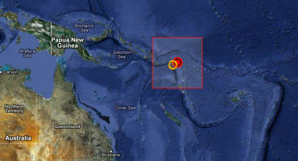
Image credit: TW
Swarm of strong and shallow earthquakes struck Santa Cruz Islands region, starting with January 30, 2013. Strong M 6.0 (USGS) hit island region on January 30, 2013 at 23:03 UTC.
The strongest earthquake was measured as M 6.2 on January 31, 2013 at 03:33 UTC, (four hours after M 6.0) with epicenter located 60 km (37 miles) E of Lata, Solomon Islands at depth of 9.2 km (5.7 miles). There was no tsunami alert issued.
| Magnitude | 6.2 |
|---|---|
| Date-Time |
|
| Location | 10.628°S, 166.382°E |
| Depth | 9.2 km (5.7 miles) |
| Region | SANTA CRUZ ISLANDS |
| Distances | 60 km (37 miles) E of Lata, Solomon Islands 544 km (338 miles) N of Luganville, Vanuatu 717 km (445 miles) ESE of Honiara, Solomon Islands 809 km (502 miles) NNW of Port-Vila, Vanuatu |
| Location Uncertainty | horizontal +/- 14.7 km (9.1 miles); depth +/- 3.2 km (2.0 miles) |
| Parameters | NST=414, Nph=420, Dmin=718 km, Rmss=0.82 sec, Gp= 25°, M-type=regional moment magnitude (Mw), Version=9 |
| Source |
|
| Event ID | usc000ez0w |
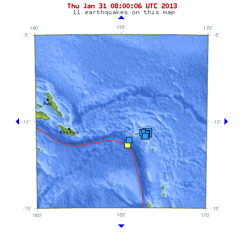
By the time of this report (January 31, 2013 – 08:40 UTC), Santa Cruz Islands experienced nine strong earthquakes ranging between M 4.6 and M 5.6. The Santa Cruz Islands are less than five million years old, and were pushed upward by the tectonic subduction of the northward-moving Indo-Australian Plate under the Pacific Plate. The islands are mostly composed of limestone and volcanic ash over limestone.
World earthquakes list
Update time = Thursday, January 31, 2013 at 9:37 UTC
Source: USGS
| MAG | UTC DATE-TIME y/m/d h:m:s | LAT deg | LON deg | DEPTH km | Region |
|---|---|---|---|---|---|
| 4.3 | 2013/01/31 08:27:29 | -7.271 | 144.084 | 33.3 | NEAR SOUTH COAST OF NEW GUINEA, P.N.G. |
| 2.9 | 2013/01/31 08:06:34 | 33.392 | -116.847 | 6.7 | SOUTHERN CALIFORNIA |
| 4.9 | 2013/01/31 06:50:17 | -10.418 | 166.251 | 35.0 | SANTA CRUZ ISLANDS |
| 5.1 | 2013/01/31 06:42:11 | -10.713 | 166.386 | 35.2 | SANTA CRUZ ISLANDS |
| 5.4 | 2013/01/31 05:18:15 | -10.567 | 166.446 | 45.7 | SANTA CRUZ ISLANDS |
| 5.0 | 2013/01/31 05:16:58 | -10.502 | 166.201 | 25.0 | SANTA CRUZ ISLANDS |
| 4.6 | 2013/01/31 05:10:53 | -28.053 | -70.927 | 46.1 | ATACAMA, CHILE |
| 2.6 | 2013/01/31 04:35:05 | 60.183 | -151.274 | 60.7 | KENAI PENINSULA, ALASKA |
| 5.6 | 2013/01/31 04:31:33 | -10.934 | 165.418 | 32.9 | SANTA CRUZ ISLANDS |
| 4.5 | 2013/01/31 04:15:56 | -27.878 | -70.941 | 26.8 | ATACAMA, CHILE |
| 5.0 | 2013/01/31 04:10:46 | -4.613 | 102.515 | 51.7 | SOUTHERN SUMATRA, INDONESIA |
| 2.6 | 2013/01/31 04:01:13 | 46.285 | -122.208 | 5.0 | MOUNT ST. HELENS AREA, WASHINGTON |
| 5.6 | 2013/01/31 03:58:00 | -10.680 | 166.391 | 35.1 | SANTA CRUZ ISLANDS |
| 6.2 | 2013/01/31 03:33:44 | -10.628 | 166.382 | 9.2 | SANTA CRUZ ISLANDS |
| 4.8 | 2013/01/31 02:45:00 | -28.504 | -67.365 | 117.7 | LA RIOJA, ARGENTINA |
| 4.3 | 2013/01/31 02:26:21 | 49.877 | 150.751 | 355.5 | NORTHWEST OF THE KURIL ISLANDS |
| 2.7 | 2013/01/31 01:48:18 | 60.371 | -152.835 | 119.7 | SOUTHERN ALASKA |
| 2.9 | 2013/01/31 01:12:08 | 18.890 | -64.453 | 38.0 | VIRGIN ISLANDS REGION |
| 3.7 | 2013/01/31 01:03:17 | 45.919 | -122.409 | 7.6 | WASHINGTON |
Commenting rules and guidelines
We value the thoughts and opinions of our readers and welcome healthy discussions on our website. In order to maintain a respectful and positive community, we ask that all commenters follow these rules.