
Smoke continues to plague India and Bangladesh even months after onset of fires
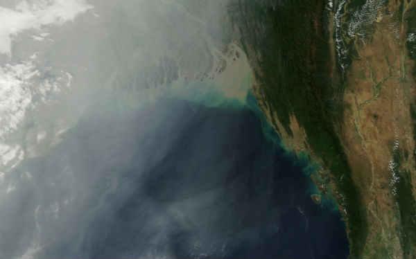
Image credit: TW
Smoke from agricultural fires continues to plague northern India and its eastern neighbor, Bangladesh. Thick clouds of smoke plague Indian subcontinent since late October, 2012.
 The cloud obscures northeastern India and much of Bangladesh on January 11, 2013. The mouths of the Ganges are partially visible below the image center. (Credit: LANCE/MODIS)
The haze likely resulted from a combination of urban and industrial pollution, agricultural fires, and a regional meteorological phenomenon known as a temperature inversion. Usually the air higher in the atmosphere is cooler than the air near the surface, a situation that allows warm air to rise and disperse pollutants. However, cold air often settles over northern India in the winter, trapping warmer air—and pollution—close to the surface, where it has the greatest impact on human health.
 On January 10, the Moderate Resolution Imaging Spectroradiometer (MODIS) on NASA’s Aqua satellite captured this image of haze hugging the Himalayas and spilling out into the Ganges delta and Bengal Sea. (Credit: LANCE/MODIS)
Air quality has emerged as a significant problem for India and Bangladesh in the past decade. A study conducted by Tel Aviv University researchers and published in the American Journal of Climate Change found that levels of air pollution in large Indian cities increased at some of the fastest rates in the world between 2002 and 2010—faster even than rapidly-growing Chinese cities.
Source: Earth Snapshots, Earth Observatory

Earlier reporting
Nothing on Watchers was published in the last 24 hours. These are older articles.
- Bay of Bengal system to become Cyclone Akvan, landfall forecast between Nellore and Tuni on November 20, India
- On October 22, 2017, a single flash of lightning stretched 515 miles from eastern Texas to near Kansas City, a distance that takes eight hours to drive, and nobody realized how far it had gone until scientists went back through the satellite data years later Epicenter
- CPC posts a slight risk of heavy rain from the Gulf Coast to the Northeast urban corridor November 25-29, and a moderate risk of West Coast wind and Sierra snow on November 25
- Florida's east coast faces a moderate flash flood risk Wednesday through Friday, with 4 to 8 inches of rain forecast and the St. Johns River near Cocoa already in major flood at 17.13 feet
