
Active volcanoes in the world: October 10 – October 16, 2012
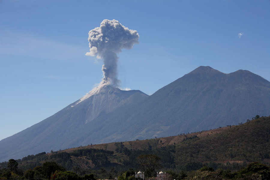
Image credit: TW
New unrest has been noticed around 5 volcanoes, ongoing activity was reported for 11 volcanoes. This report covers active volcanoes in the world recorded from October 10 – October 16, 2012 based on Smithsonian/USGS criteria.
The Weekly Volcanic Activity Report is a cooperative project between the Smithsonian’s Global Volcanism Program and the US Geological Survey’s Volcano Hazards Program. Updated by 23:00 UTC every Wednesday, notices of volcanic activity posted on these pages are preliminary and subject to change as events are studied in more detail. This is not a comprehensive list of all of Earth’s volcanoes erupting during the week, but rather a summary of activity at volcanoes that meet criteria discussed in detail in the “Criteria and Disclaimers” section. Carefully reviewed, detailed reports on various volcanoes are published monthly in the Bulletin of the Global Volcanism Network.
New activity/unrest: | Alaid, Kuril Islands (Russia) | Gamalama, Halmahera | Kliuchevskoi, Central Kamchatka (Russia) | Paluweh, Lesser Sunda Islands (Indonesia) | Sangeang Api, Lesser Sunda Islands (Indonesia)
Ongoing activity: | Etna, Sicily (Italy) | Fuego, Guatemala | Galeras, Colombia | Karymsky, Eastern Kamchatka (Russia) | Kilauea, Hawaii (USA) | Manam, Northeast of New Guinea (SW Pacific) |Popocatépetl, México | Sakura-jima, Kyushu | Santa María, Guatemala | Shiveluch, Central Kamchatka (Russia) | Tongariro, North Island (New Zealand)
Ongoing activity
ALAID, Kuril Islands (Russia)
50.858°N, 155.55°E; summit elev. 2339 m
According to KVERT, observers on Paramushir Island reported that on 5 October a large gas-and-steam plume from Alaid rose 200 m above the crater. A thermal anomaly on the volcano was detected in satellite imagery for 7.5 hours the next day. The increased activity prompted KVERT to raise the Aviation Color Code to Yellow on 7 October. Satellite imagery detected a thermal anomaly on 15 October.
Geologic summary: The highest and northernmost volcano of the Kurile Islands, 2,339-m-high Alaid is a symmetrical stratovolcano when viewed from the N, but has a 1.5-km-wide summit crater that is breached widely to the S. Alaid is the northernmost of a chain of volcanoes constructed W of the main Kuril archipelago and rises 3,000 m from the floor of the Sea of Okhotsk. Numerous pyroclastic cones dot the lower flanks of Alaid, particularly on the NW and SE sides, including an offshore cone formed during the 1933-34 eruption. Strong explosive eruptions have occurred from the summit crater beginning in the 18th century. Reports of eruptions in 1770, 1789, 1821, 1829, 1843, 1848, and 1858 were considered incorrect by Gorshkov (1970). Explosive eruptions in 1790 and 1981 were among the largest in the Kurile Islands.
GAMALAMA, Halmahera
0.80°N, 127.33°E; summit elev. 1715 m
CVGHM reported that eruptions at Gamalama during 15-16 September prompted CVGHM to raise the Alert Level to 3 (on a scale of 1-4) on 16 September. An eruption on 17 September produced a white-and-gray plume that rose 300 m above the crater and drifted E and SE. Ashfall was reported in the ESE part of Ternate (S, SE, and E part of island). After the eruption through 8 October white plumes rose 10-50 m high. Seismicity decreased in early October. The Alert Level was decreased to 2 on 9 October. Visitors and residents were warned not to approach the crater within a radius of 1.5 km.
Geologic summary: Gamalama (Peak of Ternate) is a near-conical stratovolcano that comprises the entire island of Ternate off the western coast of Halmahera and is one of Indonesia’s most active volcanoes. The island of Ternate was a major regional center in the Portuguese and Dutch spice trade for several centuries, which contributed to the thorough documentation of Gamalama’s historical activity. Three cones, progressively younger to the N, form the summit of Gamalama, which reaches 1,715 m. Several maars and vents define a rift zone, parallel to the Halmahera island arc, that cuts the volcano. Eruptions, recorded frequently since the 16th century, typically originated from the summit craters, although flank eruptions have occurred in 1763, 1770, 1775, and 1962-63.
KLIUCHEVSKOI, Central Kamchatka (Russia)
56.057°N, 160.638°E; summit elev. 4835 m
KVERT reported that seismic activity at Kliuchevskoi had been gradually increasing since June; episodes of volcanic tremor were first detected on 21 June and continued through 14 October. A weak thermal anomaly was detected in satellite imagery during 1 September-14 October. Strombolian activity was observed at night during 14-15 October. The Aviation Color Code was raised to Yellow.
Geologic summary: Kliuchevskoi is Kamchatka’s highest and most active volcano. Since its origin about 7,000 years ago, the beautifully symmetrical, 4,835-m-high basaltic stratovolcano has produced frequent moderate-volume explosive and effusive eruptions without major periods of inactivity. More than 100 flank eruptions, mostly on the NE and SE flanks of the conical volcano between 500 m and 3,600 m elevation, have occurred during the past 3,000 years. The morphology of its 700-m-wide summit crater has been frequently modified by historical eruptions, which have been recorded since the late-17th century. Historical eruptions have originated primarily from the summit crater, but have also included major explosive and effusive events from flank craters.
PALUWEH, Lesser Sunda Islands (Indonesia)
8.32°S, 121.708°E; summit elev. 875 m
Based on seismic data and visual observations, CVGHM raised the Alert Level for Paluweh from 2 to 3 (on a scale of 1-4) on 13 October. The Alert Level had been raised to 2 five days earlier.
Geologic summary: Paluweh volcano, also known as Rokatenda, forms the 8-km-wide island of Paluweh N of the volcanic arc that cuts across Flores Island. Although the volcano rises about 3,000 m above the sea floor, its summit reaches only 875 m above sea level. The broad irregular summit region contains overlapping craters up to 900 m wide and several lava domes. Several flank vents occur along a NW-trending fissure. The largest historical eruption of Paluweh occurred in 1928, when a strong explosive eruption was accompanied by landslide-induced tsunamis and lava-dome emplacement.
SANGEANG API, Lesser Sunda Islands (Indonesia)
8.20°S, 119.07°E; summit elev. 1949 m
CVGHM reported that during 1-10 October Sangeang Api was often not visible due to fog; occasionally plumes were visible and rose as high as 20 m above the crater. The lava dome and surrounding areas had not changed compared to the beginning of the year. Both the number and magnitude of earthquakes increased on 5 October, declined during 6-8 October, then again increased on 9 October. The Alert Level was raised to 3 (on a scale of 1-4) on 10 October.
Geologic summary: Sangeang Api volcano, one of the most active in the Lesser Sunda Islands, forms a small 13-km-wide island off the NE coast of Sumbawa Island. Two large trachybasaltic-to-tranchyandesitic volcanic cones, 1949-m-high Doro Api and 1795-m-high Doro Mantoi, were constructed in the center and on the eastern rim, respectively, of an older, largely obscured caldera. Flank vents occur on the south side of Doro Mantoi and near the northern coast. Intermittent historical eruptions have been recorded since 1512.
Ongoing activity
ETNA, Sicily (Italy)
37.734°N, 15.004°E; summit elev. 3330 m
Sezione di Catania – Osservatorio Etneo reported that on the evening of 2 October weak Strombolian activity resumed within Etna’s Bocca Nuova crater, from the same vent on the SE part of the crater floor that was active in July and August 2012. On 3 October the activity was accompanied by a small inter-crater lava flow on the S part of the floor. Over the next few days the activity slowly intensified and a small new cone developed over the old cone formed during July-August, which had subsequently nearly completely collapsed. Volcanic tremor amplitude rapidly increased on the evening of 6 October at the same time eruptive activity intensified. Lava flowed towards the W part of the crater floor and lava fountains pulsated. The intensity of both the eruptive activity and the volcanic tremor amplitude peaked just after midnight on 7 October, and strong glow from the crater was observed from nearby populated areas. Some of the lava jets rose well above the crater rim. Activity decreased at 0430, and the next day dropped to the lowest levels recorded for many weeks.
Geologic summary: Mount Etna, towering above Catania, Sicily’s second largest city, has one of the world’s longest documented records of historical volcanism, dating back to 1500 BC. Historical lava flows cover much of the surface of this massive basaltic stratovolcano, the highest and most voluminous in Italy. Two styles of eruptive activity typically occur at Etna. Persistent explosive eruptions, sometimes with minor lava emissions, take place from one or more of the three prominent summit craters, the Central Crater, NE Crater, and SE Crater. Flank eruptions, typically with higher effusion rates, occur less frequently and originate from fissures that open progressively downward from near the summit. A period of more intense intermittent explosive eruptions from Etna’s summit craters began in 1995. The active volcano is monitored by the Instituto Nazionale di Geofisica e Volcanologia (INGV) in Catania.
FUEGO, Guatemala
14.473°N, 90.880°W; summit elev. 3763 m
INSIVUMEH reported that during 10-11 October lava flows traveled 200 m down the Ceniza drainage, on Fuego’s SSW flank, producing incandescent block avalanches from the flow front and steam-and-tephra plumes. On 12 October a lava flow on the S flank traveled 800 m. Explosions produced ash plumes that rose 500 m and drifted 10 km S. During 14-16 October explosions produced ash plumes that rose 400 m and drifted W and SW. A lava flow traveled 800 m down the Ceniza drainage, producing incandescent block avalanches that reached vegetated areas.
Geologic summary: Volcán Fuego, one of Central America’s most active volcanoes, is one of three large stratovolcanoes overlooking Guatemala’s former capital, Antigua. The scarp of an older edifice, Meseta, lies between 3,763-m-high Fuego and its twin volcano to the N, Acatenango. Construction of Meseta volcano continued until the late Pleistocene or early Holocene, after which growth of the modern Fuego volcano continued the southward migration of volcanism that began at Acatenango. Frequent vigorous historical eruptions have been recorded at Fuego since the onset of the Spanish era in 1524, and have produced major ashfalls, along with occasional pyroclastic flows and lava flows. The last major explosive eruption from Fuego took place in 1974, producing spectacular pyroclastic flows visible from Antigua.
GALERAS, Colombia
1.22°N, 77.37°W; summit elev. 4276 m
INGEOMINAS reported that during 9-16 October cameras around Galeras recorded daily emissions; on 9 and 12 October ash was present in the emissions in small quantities. On 12 October a gas-and-ash plume rose 1 km above the crater, and staff at the Galeras National Park Wildlife Sanctuary reported sulfur gas odor in a cabin located on the E side of the volcano. Earthquakes were at most M 1.7 and occurred within 10 km of the crater at depths of less than 6 km. The Alert Level remained at III (Yellow; “changes in the behavior of volcanic activity”).
Geologic summary: Galeras, a stratovolcano with a large breached caldera located immediately W of the city of Pasto, is one of Colombia’s most frequently active volcanoes. The dominantly andesitic Galeras volcanic complex has been active for more than 1 million years, and two major caldera collapse eruptions took place during the late Pleistocene. Longterm extensive hydrothermal alteration has affected the volcano. This has contributed to large-scale edifice collapse that has occurred on at least three occasions, producing debris avalanches that swept to the W and left a large horseshoe-shaped caldera inside which the modern cone has been constructed. Major explosive eruptions since the mid Holocene have produced widespread tephra deposits and pyroclastic flows that swept all but the southern flanks. A central cone slightly lower than the caldera rim has been the site of numerous small-to-moderate historical eruptions since the time of the Spanish conquistadors.
KARYMSKY, Eastern Kamchatka (Russia)
54.05°N, 159.45°E; summit elev. 1536 m
KVERT reported moderate seismic activity from Karymsky during 5-12 October. Seismic data indicated that ash plumes possibly rose to an altitude of 6.5 km (21,300 ft) a.s.l. Satellite imagery showed an ash plume drifting 42 km SE on 6 October, and a thermal anomaly on the volcano on 7 and 11 October. The Aviation Color Code remained at Orange.
Based on analyses of satellite imagery, the Tokyo VAAC reported that on 16 October a possible eruption produced a plume that rose to an altitude of 4 km (13,000 ft) a.s.l. and drifted N. Ash was detected in a subsequent image.
Geologic summary: Karymsky, the most active volcano of Kamchatka’s eastern volcanic zone, is a symmetrical stratovolcano constructed within a 5-km-wide caldera that formed about 7,600-7,700 radiocarbon years ago. Construction of the Karymsky stratovolcano began about 2,000 years later. The latest eruptive period began about 500 years ago, following a 2,300-year quiescence. Much of the cone is mantled by lava flows less than 200 years old. Historical eruptions have been Vulcanian or Vulcanian-Strombolian with moderate explosive activity and occasional lava flows from the summit crater. Most seismicity preceding Karymsky eruptions has originated beneath Akademia Nauk caldera, which is located immediately S of Karymsky volcano and erupted simultaneously with Karymsky in 1996.
KILAUEA, Hawaii (USA)
19.421°N, 155.287°W; summit elev. 1222 m
During 10-16 October HVO reported that the circulating lava lake periodically rose and fell in the deep pit within Kilauea’s Halema’uma’u Crater. Occasional measurements indicated that the gas plume from the vent continued to deposit variable amounts of spatter and Pele’s hair onto nearby areas.
Lava flows accumulated at the base of the pali in the Royal Gardens subdivision and flowed across the coastal plain, but were 1.7 km from the coast on 10 October. Flows also remained active high on the pali. At Pu’u ‘O’o Crater, incandescence was visible from lava flows in the S pit, lava circulating in the NE pit, and from the W edge of the crusted N pit. On 12 October lava erupted from an incandescence spatter cone at the W edge of the N pit, filling a low depression on the N side of the crater floor and extending almost to the NE pit and lava lake. Small flows erupted from a spatter cone in the S pit during 13-14 and 16 October.
Geologic summary: Kilauea, one of five coalescing volcanoes that comprise the island of Hawaii, is one of the world’s most active volcanoes. Eruptions at Kilauea originate primarily from the summit caldera or along one of the lengthy E and SW rift zones that extend from the caldera to the sea. About 90% of the surface of Kilauea is formed of lava flows less than about 1,100 years old; 70% of the volcano’s surface is younger than 600 years. A long-term eruption from the East rift zone that began in 1983 has produced lava flows covering more than 100 sq km, destroying nearly 200 houses and adding new coastline to the island.
MANAM, Northeast of New Guinea (SW Pacific)
4.080°S, 145.037°E; summit elev. 1807 m
RVO reported that Manam’s Southern Crater continued to erupt during 1-15 October. Activity was low the first few days, characterized by emissions of light gray ash plumes, occasional dark gray plumes, and ejected incandescent tephra. The intensity of ejected incandescent tephra increased on 5 October, and peaked during 9-10 October when the ejections developed into Strombolian activity. Strong explosions during the Strombolian activity produced shock waves that rattled houses on the S part of the island. Activity subsided after 10 October; erupted material fell in the SE and SE valleys. There was a corresponding increase in emissions of ash clouds that drifted NW but the volume of ash appeared insignificant. White vapor plumes rose from Main Crater during the reporting period.
Based on analyses of satellite imagery, the Darwin VAAC reported that on 15 October an ash plume rose to an altitude of 3 km (10,000 ft) a.s.l. and drifted 37 km SW.
Geologic summary: The 10-km-wide island of Manam, lying 13 km off the northern coast of mainland Papua New Guinea, is one of the country’s most active volcanoes. Four large radial valleys extend from the unvegetated summit of the conical 1807-m-high basaltic-andesitic stratovolcano to its lower flanks. These “avalanche valleys,” regularly spaced 90 degrees apart, channel lava flows and pyroclastic avalanches that have sometimes reached the coast. Two summit craters are present; both are active, although most historical eruptions have originated from the southern crater, concentrating eruptive products during much of the past century into the SE avalanche valley. Frequent historical eruptions, typically of mild-to-moderate scale, have been recorded at Manam since 1616. Occasional larger eruptions have produced pyroclastic flows and lava flows that reached flat-lying coastal areas and entered the sea, sometimes impacting populated areas.
POPOCATEPETL, México
19.023°N, 98.622°W; summit elev. 5426 m
CENAPRED reported that during 10-16 October seismicity at Popocatépetl indicated continuing gas-and-steam emissions; during 10-13 the emissions observed drifting W and NW. During 14-16 October ash was present in the gas-and-steam plumes. Plumes rose 1.5 km above the crater and drifted W, WSW, and NW. Incandescence from the crater was observed at night. The Alert Level remained at Yellow, Phase Two.
Geologic summary: Popocatépetl, whose name is the Aztec word for smoking mountain, towers to 5,426 m 70 km SE of Mexico City and is North America’s second-highest volcano. Frequent historical eruptions have been recorded since the beginning of the Spanish colonial era. A small eruption on 21 December 1994 ended five decades of quiescence. Since 1996 small lava domes have incrementally been constructed within the summit crater and destroyed by explosive eruptions. Intermittent small-to-moderate gas-and-ash eruptions have continued, occasionally producing ashfall in neighboring towns and villages.
SAKURA-JIMA, Kyushu
31.585°N, 130.657°E; summit elev. 1117 m
Based on information from JMA, the Tokyo VAAC reported that explosions from Sakura-jima’s Showa Crater during 12 and 14-15 October produced plumes that rose to altitudes of 1.8-3 km (6,000-10,000 ft) a.s.l. and drifted W, SW, and SE. On 12 October a pilot observed an ash plume that rose to an altitude of 2.4 km (8,000 ft) a.s.l. and drifted SE. JMA reported that during 12-15 October explosions ejected tephra as far as 800 m from the crater.
Geologic summary: Sakura-jima, one of Japan’s most active volcanoes, is a post-caldera cone of the Aira caldera at the northern half of Kagoshima Bay. Eruption of the voluminous Ito pyroclastic flow was associated with the formation of the 17 x 23-km-wide Aira caldera about 22,000 years ago. The construction of Sakura-jima began about 13,000 years ago and built an island that was finally joined to the Osumi Peninsula during the major explosive and effusive eruption of 1914. Activity at the Kita-dake summit cone ended about 4,850 years ago, after which eruptions took place at Minami-dake. Frequent historical eruptions, recorded since the 8th century, have deposited ash on Kagoshima, one of Kyushu’s largest cities, located across Kagoshima Bay only 8 km from the summit. The largest historical eruption took place during 1471-76.
SANTA MARIA, Guatemala
14.756°N, 91.552°W; summit elev. 3772 m
INSIVUMEH reported that during 11-12 October white plumes from Santa María’s Caliente dome rose 3.9 km and drifted S and SE. According to the Washington VAAC, INSIVUMEH reported a lava-dome collapse on 14 October. An ash plume observed in satellite imagery drifted WSW and W, and then dissipated. INSIVUMEH noted that during 15-16 October white plumes rose 400 m and drifted SW and W. An explosion generated a white plume that rose 600 m, and white plumes rose 50 m above the fronts of active lava flows.
Geologic summary: Symmetrical, forest-covered Santa María volcano is one of a chain of large stratovolcanoes that rises dramatically above the Pacific coastal plain of Guatemala. The stratovolcano has a sharp-topped, conical profile that is cut on the SW flank by a large, 1-km-wide crater, which formed during a catastrophic eruption in 1902 and extends from just below the summit to the lower flank. The renowned Plinian eruption of 1902 followed a long repose period and devastated much of SW Guatemala. The large dacitic Santiaguito lava-dome complex has been growing at the base of the 1902 crater since 1922. Compound dome growth at Santiaguito has occurred episodically from four westward-younging vents, accompanied by almost continuous minor explosions and periodic lava extrusion, larger explosions, pyroclastic flows, and lahars.
SHIVELUCH, Central Kamchatka (Russia)
56.653°N, 161.360°E; summit elev. 3283 m
Based on visual observations and analyses of satellite data, KVERT reported that during 5-12 October a viscouslava flow continued to effuse on the NW flank of Shiveluch’s lava dome, accompanied by hot avalanches and fumarolic activity. Satellite imagery showed ash plumes drifting 360 km SE during 4-6 October, and a thermal anomaly on the lava dome during 5-7 October. A plume detected by the seismic network and observed rose to altitudes of 6-7 km (19,700-23,000 ft) a.s.l. on 6 October. The Aviation Color Code remained at Orange.
Geologic summary: The high, isolated massif of Shiveluch volcano (also spelled Sheveluch) rises above the lowlands NNE of the Kliuchevskaya volcano group and forms one of Kamchatka’s largest and most active volcanoes. The currently active Molodoy Shiveluch lava-dome complex was constructed during the Holocene within a large breached caldera formed by collapse of the massive late-Pleistocene Strary Shiveluch volcano. At least 60 large eruptions of Shiveluch have occurred during the Holocene, making it the most vigorous andesitic volcano of the Kuril-Kamchatka arc. Frequent collapses of lava-dome complexes, most recently in 1964, have produced large debris avalanches whose deposits cover much of the floor of the breached caldera. Intermittent explosive eruptions began in the 1990s from a new lava dome that began growing in 1980. The largest historical eruptions from Shiveluch occurred in 1854 and 1964.
TONGARIRO, North Island (New Zealand)
39.13°S, 175.642°E; summit elev. 1978 m
On 12 October, the GeoNet Data Centre reported that Tongariro had been degassing after the 6 August eruption from the Te Mari Craters. Gas plumes drifted downwind and were detected a hundred kilometers or more away. During the previous two weeks an odor was noticed in Manawatu (112 km S) and Hawke’s Bay (120 km ESE).
Geologic summary: Tongariro is a large andesitic volcanic massif, located immediately NE of Ruapehu volcano, that is composed of more than a dozen composite cones constructed over a period of 275,000 years. Vents along a NE-trending zone extending from Saddle Cone (below Ruapehu volcano) to Te Mari crater (including vents at the present-day location of Ngauruhoe) were active during a several hundred year long period around 10,000 years ago, producing the largest known eruptions at the Tongariro complex during the Holocene. The youngest cone of the complex, Ngauruhoe, has grown to become the highest peak of the massif since its birth about 2500 years ago. The symmetrical, steep-sided Ngauruhoe, along with its neighbor Ruapehu to the south, have been New Zealand’s most active volcanoes during historical time.
Source: Global Volcanism Program
I'm a dedicated researcher, journalist, and editor at The Watchers. With over 20 years of experience in the media industry, I specialize in hard science news, focusing on extreme weather, seismic and volcanic activity, space weather, and astronomy, including near-Earth objects and planetary defense strategies. You can reach me at teo /at/ watchers.news.
[…] https://watchers.news/2012/10/18/active-volcanoes-world-october-10-october-16-2012/ […]
[…] https://watchers.news/2012/10/18/active-volcanoes-world-october-10-october-16-2012/ […]