
Flooding along the Brahmaputra River in northeastern India (satellite view)
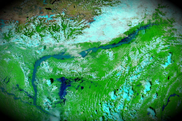
Image credit: Satellite view of flooding around Brahmaputra River captured on September 25, 2012 by MODIS/Aqua satellite (NASA image courtesy LANCE MODIS Rapid Response Team at NASA GSFC.)
Heavy monsoon rains caused flash floods and landslides in northeastern India. Flooding along Brahmaputra River caused displacement of more than 1.7 million people living around its banks. States of Sikkim, Assam and Arunachal Pradesh are the worst affected.
The fast-rising river affected settlements along its banks, including Tezpur and Guwahati. Satellite images by MODIS/Terra and Aqua satellites show a stretch of the Brahmaputra River, which flows through northeastern India en route to Bangladesh.

Military helicopters dropped packages of food and drinking water to displaced residents seeking higher ground.
This is the third time this year that Brahmaputra River is pushed over it banks. The Brahmaputra has flooded in June and in August.
I am of the firm opinion that-Advance Countries are doing all these things with the help of HAARP Weather war Star war technique from the sky to destabilize the world in regards to FOOD and WATER as a military strategy to create chaos in undeveloped and developing countries.