
Active volcanoes in the world: July 25 – July 31, 2012
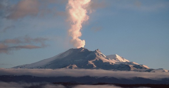
Image credit: Mt. Tongariro, New Zealand
New unrest has been noticed around 3 volcanoes, ongoing activity was reported for 14 volcanoes. This report covers active volcanoes in the world recorded from July 25 – July 31, 2012 based on Smithsonian/USGS criteria.
CUMBAL, Colombia
0.95°N, 77.87°W; summit elev. 4764 m
According to INGEOMINAS, the Observatorio de Pasto reported that during 25-31 July seismic signals related to movement of fluid decreased compared to the previous week; earthquake swarms were detected on 26, 27, 29, and 30 July. The number and magnitude of earthquakes generated by fracturing rock increased. Four of the events were located SW of the volcano at a depth of 10 km, and less than M 2.1. Weather conditions prevented observations of the volcano. The Alert Level remained at III (Yellow; “changes in the behavior of volcanic activity”).
Geologic summary: Many youthful lava flows extend from the glacier-capped Cumbal volcano, the southernmost historically active volcano of Colombia. The volcano is elongated in a NE-SW direction and is composed primarily of andesitic-dacitic lava flows. Two fumarolically active craters occupy the summit ridge; the main crater on the NE side and Mundo Nuevo crater on the SW side. A young lava dome occupies the 250-m-wide summit crater, and eruptions from the upper east flank produced a 6-km-long lava field. The oldest crater lies NNE of the summit crater, suggesting SW-ward migration of activity. Explosive eruptions in 1877 and 1926 are the only known historical activity from Cumbal. Fumarole fields are found in the two summit craters, and thermal springs are located on the SE flanks.
TONGARIRO, North Island (New Zealand)
39.13°S, 175.642°E; summit elev. 1978 m
On 31 July GeoNet reported that seismicity at Tongariro had declined the previous week but increased again during 28-29 July, and as of 31 July, between 3 and 10 events were being recorded daily. The earthquakes were clustered in a zone between Tongariro and the E side of Lake Rotoaira, at 2-7 km depth. The Alert Level remained at 1 (on a scale of 0-5) and the Aviation Colour Code remained at Yellow (on a four-color scale).
Geologic summary: Tongariro is a large andesitic volcanic massif, located immediately NE of Ruapehu volcano, that is composed of more than a dozen composite cones constructed over a period of 275,000 years. Vents along a NE-trending zone extending from Saddle Cone (below Ruapehu volcano) to Te Mari crater (including vents at the present-day location of Ngauruhoe) were active during a several hundred year long period around 10,000 years ago, producing the largest known eruptions at the Tongariro complex during the Holocene. The youngest cone of the complex, Ngauruhoe, has grown to become the highest peak of the massif since its birth about 2500 years ago. The symmetrical, steep-sided Ngauruhoe, along with its neighbor Ruapehu to the south, have been New Zealand’s most active volcanoes during historical time.
YASUR, Vanuatu (SW Pacific)
19.53°S, 169.442°E; summit elev. 361 m
Following an assessment during 7-12 July, the Geohazards Observatory team concluded that explosive activity at Yasur had slightly increased, becoming stronger and more frequent, and shifting from Strombolian to sub-Plinian. Bombs ejected from the vents fell in the crater, around the summit area, and on the tourist walk and parking area. The explosions were heard, felt, and observed from nearby villages and schools. Activity at all three volcanic vents was characterized by degassing, ash emissions, and ejection of bombs. On 13 July the Alert Level was raised to 3 (on a scale of 0-4).
Geologic summary: Yasur, the best-known and most frequently visited of the Vanuatu volcanoes, has been in more-or-less continuous Strombolian and vulcanian activity since Captain Cook observed ash eruptions in 1774. This style of activity may have continued for the past 800 years. Yasur is a mostly unvegetated pyroclastic cone with a nearly circular, 400-m-wide summit crater. Yasur is largely contained within the small Yenkahe caldera in SE Tanna Island. It is the youngest of a group of Holocene volcanic centers constructed over the down-dropped NE flank of the Pleistocene Tukosmeru volcano. Active tectonism along the Yenkahe horst accompanying eruptions of Yasur has raised Port Resolution harbor more than 20 m during the past century.
Ongoing activity
BATU TARA, Komba Island (Indonesia)
7.792°S, 123.579°E; summit elev. 748 m
Based on analyses of satellite imagery, the Darwin Volcanic Ash Advisory Centre (VAAC) reported that during 24-31 July ash plumes from Batu Tara rose to an altitude of 2.1 km (7,000 ft) a.s.l. and drifted 37-110 km W, NW, and N.
Geologic summary: The small isolated island of Batu Tara in the Flores Sea about 50 km north of Lembata (formerly Lomblen) Island contains a scarp on the eastern side similar to the Sciara del Fuoco of Italy’s Stromboli volcano. Vegetation covers the flanks of Batu Tara to within 50 m of the 748-m-high summit. Batu Tara lies north of the main volcanic arc and is noted for its potassic leucite-bearing basanitic and tephritic rocks. The firsthistorical eruption from Batu Tara, during 1847-52, produced explosions and a lava flow.
CLEVELAN, Chuginadak Island
52.825°N, 169.944°W; summit elev. 1730 m
AVO reported that cloud cover mostly prevented satellite and web camera observations of Cleveland during 25-31 July. Slightly elevated surface temperatures were detected in satellite images during 25-26 and 29-30 July. The Volcano Alert Level remained at Watch and the Aviation Color Code remained at Orange.
Geologic summary: Symmetrical Mount Cleveland stratovolcano is situated at the western end of the uninhabited dumbbell-shaped Chuginadak Island in the east-central Aleutians. The 1,730-m-high stratovolcano is the highest of the Islands of Four Mountains group and is one of the most active in the Aleutians. Numerous large lava flows descend its flanks. It is possible that some 18th to 19th century eruptions attributed to Carlisle (a volcano located across the Carlisle Pass Strait to the NW) should be ascribed to Cleveland. In 1944 Cleveland produced the only known fatality from an Aleutian eruption. Recent eruptions from Mt. Cleveland have been characterized by short-lived explosive ash emissions, at times accompanied by lava fountaining and lava flows down the flanks.
FUEGO, Guatemala
14.473°N, 90.880°W; summit elev. 3763 m
INSIVUMEH reported that during 26-27 and 29-31 July explosions from Fuego produced ash plumes that rose 200-500 m above the crater and drifted NW, W, and SW. Fumarolic plumes drifted the same direction. Explosions ejected incandescent tephra 100 m above the crater. Lava flows traveled 300 m down the Taniluyá drainage (SW) and 150 m down the Ceniza drainage (SSW); detached blocks from both lava-flow fronts produced incandescent avalanches.
Geologic summary: Volcán Fuego, one of Central America’s most active volcanoes, is one of three largestratovolcanoes overlooking Guatemala’s former capital, Antigua. The scarp of an older edifice, Meseta, lies between 3,763-m-high Fuego and its twin volcano to the N, Acatenango. Construction of Meseta volcano continued until the late Pleistocene or early Holocene, after which growth of the modern Fuego volcano continued the southward migration of volcanism that began at Acatenango. Frequent vigorous historicaleruptions have been recorded at Fuego since the onset of the Spanish era in 1524, and have produced major ashfalls, along with occasional pyroclastic flows and lava flows. The last major explosive eruption from Fuego took place in 1974, producing spectacular pyroclastic flows visible from Antigua.
KARYMSKY, Eastern Kamchatka (Russia)
54.05°N, 159.45°E; summit elev. 1536 m
KVERT reported moderate seismic activity from Karymsky during 20-27 July. Satellite imagery showed a weak thermal anomaly on the volcano on 22 and 25 July. The Aviation Color Code remained at Orange.
Geologic summary: Karymsky, the most active volcano of Kamchatka’s eastern volcanic zone, is a symmetricalstratovolcano constructed within a 5-km-wide caldera that formed about 7,600-7,700 radiocarbon years ago. Construction of the Karymsky stratovolcano began about 2,000 years later. The latest eruptive period began about 500 years ago, following a 2,300-year quiescence. Much of the cone is mantled by lava flows less than 200 years old. Historical eruptions have been Vulcanian or Vulcanian-Strombolian with moderate explosive activity and occasional lava flows from the summit crater. Most seismicity preceding Karymsky eruptions has originated beneath Akademia Nauk caldera, which is located immediately S of Karymsky volcano and erupted simultaneously with Karymsky in 1996.
KILAUEA, Hawaii (USA)
19.421°N, 155.287°W; summit elev. 1222 m
During 25-31 July HVO reported that the circulating lava lake periodically rose and fell in the deep pit within Kilauea’s Halema’uma’u Crater. Measurements indicated that the gas plume from the vent continued to deposit variable amounts of spatter and Pele’s hair onto nearby areas. The lava pond in a small pit on the E edge of the Pu’u ‘O’o crater floor and two vents along the S edge of the floor were visible with the web cameras. Lava flows were active on the pali and the coastal plain; the active lava-flow front was about 1.8 km from the ocean on 31 July.
Geologic summary: Kilauea, one of five coalescing volcanoes that comprise the island of Hawaii, is one of the world’s most active volcanoes. Eruptions at Kilauea originate primarily from the summit caldera or along one of the lengthy E and SW rift zones that extend from the caldera to the sea. About 90% of the surface of Kilauea is formed of lava flows less than about 1,100 years old; 70% of the volcano’s surface is younger than 600 years. A long-term eruption from the East rift zone that began in 1983 has produced lava flows covering more than 100 sq km, destroying nearly 200 houses and adding new coastline to the island.
MANAM, Northeast of New Guinea (SW Pacific)
4.080°S, 145.037°E; summit elev. 1807 m
RVO reported that activity at Manam increased slightly during 15-31 July, except from 18 to 20 July when there were fewer ash emissions. During most of the reporting period, when visibility was clear, gray-to-sometimes-black ash plumes were observed rising 300-700 m above the crater from two vents and drifting NW. Rumbling was often heard on the island; rumbling on 25 July was heard on the mainland 25 km SW. Bright glow visible at night was attributed to ejected incandescent tephra. Sub-Plinian activity occurred on most nights during 21-31 July. Small lava flows descended the SW flank. Four pyroclastic flows traveled down the SE flank on 30 July at 0638, 0640, during 1200-1300, and at 1428. The first event was the largest, and generated an ash plume that rose 1.8 km above the crater and drifted NW. Emissions from Main Crater were milder and mostly characterized by white and bluish plumes, and occasional gray ash plumes.
Geologic summary: The 10-km-wide island of Manam, lying 13 km off the northern coast of mainland Papua New Guinea, is one of the country’s most active volcanoes. Four large radial valleys extend from the unvegetated summit of the conical 1807-m-high basaltic-andesitic stratovolcano to its lower flanks. These “avalanche valleys,” regularly spaced 90 degrees apart, channel lava flows and pyroclastic avalanches that have sometimes reached the coast. Two summit craters are present; both are active, although most historicaleruptions have originated from the southern crater, concentrating eruptive products during much of the past century into the SE avalanche valley. Frequent historical eruptions, typically of mild-to-moderate scale, have been recorded at Manam since 1616. Occasional larger eruptions have produced pyroclastic flows and lava flows that reached flat-lying coastal areas and entered the sea, sometimes impacting populated areas.
NEVADO DEL RUIZ, Colombia
4.895°N, 75.322°W; summit elev. 5321 m
According to INGEOMINAS, the Observatorio Vulcanológico and Sismológico de Manizales reported that on 31 July web cameras at Nevado del Ruiz showed gas-and-ash plumes rising 300 m above the crater. Seismicity was low. The Alert Level remained at II (Orange; “eruption likely within days or weeks”).
Geologic summary: Nevado del Ruiz is a broad, glacier-covered volcano in central Colombia that covers >200 sq km. Three major edifices, composed of andesitic and dacitic lavas and andesitic pyroclastics, have been constructed since the beginning of the Pleistocene. The modern cone consists of a broad cluster of lava domesbuilt within the summit caldera of an older Ruiz volcano. The 1-km-wide, 240-m-deep Arenas crater occupies the summit. Steep headwalls of massive landslides cut the flanks of Nevado del Ruiz. Melting of its summit icecap during historical eruptions, which date back to the 16th century, has resulted in devastating lahars, including one in 1985 that was South America’s deadliest eruption.
PAGAN, Mariana Islands
18.13°N, 145.80°E; summit elev. 570 m
Minor steam-and-gas plumes from Pagan were observed in satellite images during clear periods from 20 to 27 July. The Aviation Color Code remained at Yellow and the Volcano Alert Level remained at Advisory.
Geologic summary: Pagan Island, the largest and one of the most active of the Mariana Islands volcanoes, consists of two stratovolcanoes connected by a narrow isthmus. Both North and South Pagan stratovolcanoes were constructed within calderas, 7 and 4 km in diameter, respectively. The 570-m-high Mount Pagan at the NE end of the island rises above the flat floor of the caldera, which probably formed during the early Holocene. South Pagan is a 548-m-high stratovolcano with an elongated summit containing four distinct craters. Almost all of the historical eruptions of Pagan, which date back to the 17th century, have originated from North Pagan volcano. The largest eruption of Pagan during historical time took place in 1981 and prompted the evacuation of the sparsely populated island.
POPOCATEPETL, México
19.023°N, 98.622°W; summit elev. 5426 m
CENAPRED reported that during 25-31 July seismicity at Popocatépetl indicated continuing gas-and-ash emissions that sometimes probably contained ash; cloud cover prevented observations during most of this period. Incandescence from the crater was periodically observed. Steam-and-gas plumes were observed daily rising from the crater as high as 1.5 km above the rim. The plumes drifted in multiple directions. The Alert Level remained at Yellow, Phase Three.
Geologic summary: Popocatépetl, whose name is the Aztec word for smoking mountain, towers to 5,426 m 70 km SE of Mexico City and is North America’s second-highest volcano. Frequent historical eruptions have been recorded since the beginning of the Spanish colonial era. A small eruption on 21 December 1994 ended five decades of quiescence. Since 1996 small lava domes have incrementally been constructed within the summit crater and destroyed by explosive eruptions. Intermittent small-to-moderate gas-and-ash eruptions have continued, occasionally producing ashfall in neighboring towns and villages.
SAKURA-JIMA, Kyushu
31.585°N, 130.657°E; summit elev. 1117 m
JMA reported that during 24-27 July twenty explosions from Sakura-jima’s Showa Crater ejected tephra as far as 1,300 m from the crater. An explosion on 26 July produced a large ash plume. Based on information from JMA, the Tokyo VAAC reported that explosions during 25-26 and 28-31 July produced plumes that rose to altitudes of 1.5-3.7 km (5,000-12,000 ft) a.s.l. and drifted SW, W, NW, and N. Pilots observed ash plumes during 25-26 and 29 July that rose to altitudes of 2.4-3.4 km (8,000-11,000 ft) a.s.l.
Geologic summary: Sakura-jima, one of Japan’s most active volcanoes, is a post-caldera cone of the Airacaldera at the northern half of Kagoshima Bay. Eruption of the voluminous Ito pyroclastic flow was associated with the formation of the 17 x 23-km-wide Aira caldera about 22,000 years ago. The construction of Sakura-jima began about 13,000 years ago and built an island that was finally joined to the Osumi Peninsula during the major explosive and effusive eruption of 1914. Activity at the Kita-dake summit cone ended about 4,850 years ago, after which eruptions took place at Minami-dake. Frequent historical eruptions, recorded since the 8th century, have deposited ash on Kagoshima, one of Kyushu’s largest cities, located across Kagoshima Bay only 8 km from the summit. The largest historical eruption took place during 1471-76.
SANGAY, Ecuador
2.002°S, 78.341°W; summit elev. 5230 m
According to the Washington VAAC, a pilot reported that on 29 July an ash plume from Sangay rose to an altitude of 6.7 km (22,000 ft) a.s.l. and drifted W. A plume that may have been mostly gas was detected in satellite images pushing through the metrological cloud deck and drifting W.
Geologic summary: The isolated Sangay volcano, located E of the Andean crest, is the southernmost of Ecuador’s volcanoes, and its most active. It has been in frequent eruption for the past several centuries. The steep-sided, 5,230-m-high glacier-covered volcano grew within horseshoe-shaped calderas of two previous edifices, which were destroyed by collapse to the E, producing large debris avalanches that reached the Amazonian lowlands. The modern edifice dates back to at least 14,000 years ago. Sangay towers above the tropical jungle on the E side; on the other sides flat plains of ash from the volcano have been sculpted by heavy rains into steep-walled canyons up to 600 m deep. The earliest report of an historical eruption was in 1628. More or less continuous eruptions were reported from 1728 until 1916, and again from 1934 to the present. The more or less constant eruptive activity has caused frequent changes to the morphology of the summit crater complex.
SANTA MARIA, Guatemala
14.756°N, 91.552°W; summit elev. 3772 m
INSIVUMEH reported that during 26-27 July an explosion from Santa María’s Santiaguito lava-dome complex produced an ash plume that rose 400 m above Caliente dome. White gas plumes rose 200 m and drifted SW; incandescence from the crater was reflected in the plume. On 29 July pyroclastic flows descended the S flank and generated ash plumes that rose 1.5 km above the crater and drifted 15 km SW. The next day explosions produced ash plumes that rose 1.5 km and drifted 12 km WSW. During 30-31 July explosions produced ash plumes that rose 1.5 km above Caliente dome and drifted 12 km WSW. Block avalanches on the S flank generated pyroclastic flows that traveled to the base of the volcano.
Geologic summary: Symmetrical, forest-covered Santa María volcano is one of a chain of large stratovolcanoesthat rises dramatically above the Pacific coastal plain of Guatemala. The stratovolcano has a sharp-topped, conical profile that is cut on the SW flank by a large, 1-km-wide crater, which formed during a catastrophic eruption in 1902 and extends from just below the summit to the lower flank. The renowned Plinian eruption of 1902 followed a long repose period and devastated much of SW Guatemala. The large dacitic Santiaguito lava-dome complex has been growing at the base of the 1902 crater since 1922. Compound dome growth at Santiaguito has occurred episodically from four westward-younging vents, accompanied by almost continuous minor explosions and periodic lava extrusion, larger explosions, pyroclastic flows, and lahars.
SHIVELUCH, Central Kamchatka (Russia)
56.653°N, 161.360°E; summit elev. 3283 m
KVERT reported that during 20-29 July explosive activity was detected at Shiveluch and observers noted gas-and-steam activity. Satellite imagery showed a thermal anomaly on the lava dome during 20, 22-26, and 28-29 July. Based on information from KEMSD and analyses of satellite images, the Tokyo VAAC reported that on 27 July an eruption produced an ash plume that rose to an altitude of 10.1 km (33,000 ft) a.s.l. The Aviation Color Code remained at Orange.
Geologic summary: The high, isolated massif of Shiveluch volcano (also spelled Sheveluch) rises above the lowlands NNE of the Kliuchevskaya volcano group and forms one of Kamchatka’s largest and most active volcanoes. The currently active Molodoy Shiveluch lava-dome complex was constructed during the Holocenewithin a large breached caldera formed by collapse of the massive late-Pleistocene Strary Shiveluch volcano. At least 60 large eruptions of Shiveluch have occurred during the Holocene, making it the most vigorous andesiticvolcano of the Kuril-Kamchatka arc. Frequent collapses of lava-dome complexes, most recently in 1964, have produced large debris avalanches whose deposits cover much of the floor of the breached caldera. Intermittent explosive eruptions began in the 1990s from a new lava dome that began growing in 1980. The largest historicaleruptions from Shiveluch occurred in 1854 and 1964.
TUNGURAHUA, Ecuador
1.467°S, 78.442°W; summit elev. 5023 m
IG reported that during 25-31 July visual observations of Tungurahua were limited due to cloud cover. On 25 July incandescence from the crater was observed at night, an explosion generated a “cannon shot” noise, and there were sounds resembling blocks rolling down the flanks. The next day a steam plume rose 200 m above the crater and drifted W. The Juive (NNW), La Pampa (S), and Mapayacu (SW) drainages contained muddy waters on 29 July; water on the Mapayacu drainage carried blocks that were 50 cm in diameter. An explosion on 30 July produced sounds resembling rolling blocks and caused vibrating windows in surrounding areas. One small explosion was detected on 31 July.
Geologic summary: The steep-sided Tungurahua stratovolcano towers more than 3 km above its northern base. It sits ~140 km S of Quito, Ecuador’s capital city, and is one of Ecuador’s most active volcanoes. Historical eruptions have all originated from the summit crater. They have been accompanied by strong explosions and sometimes by pyroclastic flows and lava flows that reached populated areas at the volcano’s base. The last major eruption took place from 1916 to 1918, although minor activity continued until 1925. The latest eruption began in October 1999 and prompted temporary evacuation of the town of Baños on the N side of the volcano.
Source: Global Volcanism Program
I'm a dedicated researcher, journalist, and editor at The Watchers. With over 20 years of experience in the media industry, I specialize in hard science news, focusing on extreme weather, seismic and volcanic activity, space weather, and astronomy, including near-Earth objects and planetary defense strategies. You can reach me at teo /at/ watchers.news.
Commenting rules and guidelines
We value the thoughts and opinions of our readers and welcome healthy discussions on our website. In order to maintain a respectful and positive community, we ask that all commenters follow these rules.