
Strong and damaging M 5.3 earthquake hit Turkey near Sirnak and Syria border
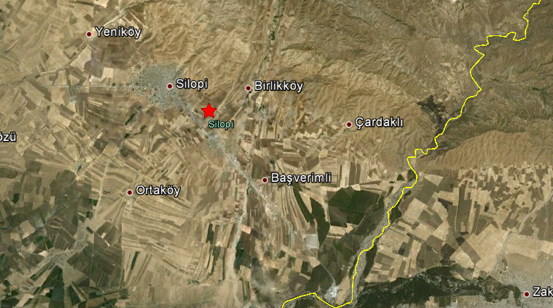
Image credit: Google Earth + USGS
Strong and damaging earthquake with recorded magnitude of 5.4 hit Turkey near Sirnak and Syria border on June 14, 2012 at 05:52 UTC according to USGS. Epicenter was located 31 km (19 miles) S of Sirnak, Turkey (37.237°N, 42.495°E). Recorded depth by USGS was 9.6 km (6.0 miles).
The Kandilli Observatory seismology center reported a magnitude 5.5 earthquake and depth of only 5.4 kilometers (3.3 miles).
The populated area Silopi (pop 74,798) is just 5 km far from epicenter area. Aftershocks continue.
At least 18 people have been injured by jumping out of windows and general panic in Silopi. Part of a minaret has also collapsed.
The 18 people wounded in various parts by the panic caused by the earthquake have been discharged from hospital. Aftershocks continue to occur and people are waiting outside. People have been warned not to go back into their homes. The Silopi State Hospital patients due to the earthquake were administered aid in tents.
An initial damage assessment will be undertaken with some slight damage to houses.
| Magnitude | 5.3 |
|---|---|
| Date-Time |
|
| Location | 37.237°N, 42.495°E |
| Depth | 9.6 km (6.0 miles) |
| Region | TURKEY-SYRIA-IRAQ BORDER REGION |
| Distances | 31 km (19 miles) S of Sirnak, Turkey 60 km (37 miles) NW of Dahuk, Iraq 114 km (70 miles) NNW of Mosul, Iraq 893 km (554 miles) ESE of ANKARA, Turkey |
| Location Uncertainty | horizontal +/- 14.6 km (9.1 miles); depth +/- 4.1 km (2.5 miles) |
| Parameters | NST=302, Nph=302, Dmin=378.5 km, Rmss=0.71 sec, Gp= 65°, M-type=body wave magnitude (Mb), Version=7 |
| Source |
|
| Event ID | usb000aflu |

Historical seismicity – since 1990

I'm a dedicated researcher, journalist, and editor at The Watchers. With over 20 years of experience in the media industry, I specialize in hard science news, focusing on extreme weather, seismic and volcanic activity, space weather, and astronomy, including near-Earth objects and planetary defense strategies. You can reach me at teo /at/ watchers.news.
[…] Visit site: The Watchers – Strong and damaging M5.3 earthquake hit Turkey … […]