
Active volcanoes in the world – April 25 – May 1, 2012
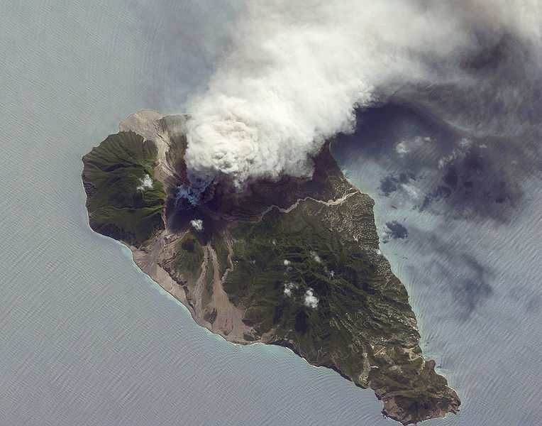
Image credit: Soufriere Hills, NASA Earth Observatory, 2009
This report covers active volcanoes recorded from April 25 – May 1, 2012 based on Smithsonian/USGS criteria. New unrest has been noticed around 5 volcanoes, ongoing activity was reported for 10 volcanoes.
BATU TARA
Komba Island (Indonesia) 7.792°S, 123.579°E; summit elev. 748 m
Based on analyses of satellite imagery, the Darwin VAAC reported that during 25-26 April ash plumes from Batu Tara rose to an altitude of 2.4 km (8,000 ft) a.s.l. and drifted 37 km W and SW. During 30 April-1 May ash plumes again rose to an altitude of 2.4 km (8,000 ft) a.s.l. then drifted 37-55 km NW.
Geologic summary: The small isolated island of Batu Tara in the Flores Sea about 50 km north of Lembata (formerly Lomblen) Island contains a scarp on the eastern side similar to the Sciara del Fuoco of Italy’s Stromboli volcano. Vegetation covers the flanks of Batu Tara to within 50 m of the 748-m-high summit. Batu Tara lies north of the main volcanic arc and is noted for its potassic leucite-bearing basanitic and tephritic rocks. The first historicaleruption from Batu Tara, during 1847-52, produced explosions and a lava flow.
CLEVELAND
Chuginadak Island 52.825°N, 169.944°W; summit elev. 1730 m
AVO reported that elevated surface temperatures were detected over Cleveland in satellite imagery during 25-29 April and possibly on 30 April. Observations showed that a small lava dome, 25 m across, had recently been emplaced.
Geologic summary: Symmetrical Mount Cleveland stratovolcano is situated at the western end of the uninhabited dumbbell-shaped Chuginadak Island in the east-central Aleutians. The 1,730-m-high stratovolcano is the highest of the Islands of Four Mountains group and is one of the most active in the Aleutians. Numerous large lava flows descend its flanks. It is possible that some 18th to 19th century eruptions attributed to Carlisle (a volcano located across the Carlisle Pass Strait to the NW) should be ascribed to Cleveland. In 1944 Cleveland produced the only known fatality from an Aleutian eruption. Recent eruptions from Mt. Cleveland have been characterized by short-lived explosive ash emissions, at times accompanied by lava fountaining and lava flows down the flanks.
IOTO
Volcano Islands (Japan) 24.754°N, 141.290°E; summit elev. 161 m
According to a JMA report on 2 May, an eruption at Ioto (Iwo-jima) caused water discoloration to the NE. A new fumarole was also confirmed.
Geologic summary: Ioto (also known as Iwo-jima) in the central Volcano Islands portion of the Izu-Marianas arc lies within a 9-km-wide submarine caldera. Ioto, Iwo-jima, and Io-jima are among many transliterations of the name, which means “Sulfur Island;” the volcano is also known as Ogasawara Io-jima to distinguish it from several other “Sulfur Island” volcanoes in Japan. The triangular, low-elevation, 8-km-long island narrows toward its SW tip and has produced trachyandesitic and trachytic rocks that are more alkalic than those of other Izu-Marianas arc volcanoes. The island has undergone dramatic uplift for at least the past 700 years accompanying resurgent doming of the caldera. A shoreline landed upon by Captain Cook’s surveying crew in 1779 is now 40 m above sea level. The Moto-yama plateau on the NE half of the island consists of submarine tuffs overlain by coral deposits and forms the island’s high point. Many fumaroles are oriented along a NE-SW zone cutting through Moto-yama. Numeroushistorical phreatic eruptions, many from vents on the west and NW sides of the island, have accompanied the remarkable uplift.
LOKON-EMPUNG
Sulawesi 1.358°N, 124.792°E; summit elev. 1580 m
According to the Darwin VAAC, ash plumes from Lokon-Empung, that rose to an altitude of 3.7 km (12,000 ft) a.s.l.and drifted 75 km N, were detected in satellite imagery and reported by ground-based observers.
Geologic summary: The twin volcanoes Lokon and Empung, rising about 800 m above the plain of Tondano, are among the most active volcanoes of Sulawesi. Lokon, the higher of the two peaks (whose summits are only 2.2 km apart) has a flat, craterless top. The morphologically younger Empung volcano has a 400-m-wide, 150-m-deep crater that erupted last in the 18th century, but all subsequent eruptions have originated from Tompaluan, a 150 x 250 m wide double crater situated in the saddle between the two peaks. Historical eruptions have primarily produced small-to-moderate ash plumes that have occasionally damaged croplands and houses, but lava-domegrowth and pyroclastic flows have also occurred.
POPOCATEPETL
México 19.023°N, 98.622°W; summit elev. 5426 m
CENAPRED reported that gas-and-steam plumes, occasionally containing ash, rose from Popocatépetl during 25-29 April. Gas-and-ash plumes rose 1.5 km above the crater on 25 and 27 April. On 28 April incandescent fragments ejected from the crater landed on E flank as far as 1 km. The next day steam-and-gas plume rose from the crater. On 1 May gas-and-steam plumes, that occasionally contained low amounts of ash, and rose 1 km above the crater. The Alert Level remained at Yellow Phase Three.
Geologic summary: Popocatépetl, whose name is the Aztec word for smoking mountain, towers to 5,426 m 70 km SE of Mexico City and is North America’s second-highest volcano. Frequent historical eruptions have been recorded since the beginning of the Spanish colonial era. A small eruption on 21 December 1994 ended five decades of quiescence. Since 1996 small lava domes have incrementally been constructed within the summit crater and destroyed by explosive eruptions. Intermittent small-to-moderate gas-and-ash eruptions have continued, occasionally producing ashfall in neighboring towns and villages.7
Ongoing activity
BULUSAN
Luzon 12.770°N, 124.05°E; summit elev. 1565 m
PHIVOLCS reported that the Alert Level for Bulusan was lowered to 0 (on a scale of 0-5) on 24 April following a decline in activity after a phreatic eruption on 13 May 2011. The frequency of earthquakes decreased to baseline levels of 0-2 per day, measurements indicated deflation since late November 2011, and steaming activity from the crater and known thermal vents had been frequently weak compared to more moderate steam emissions during periods of unrest. Entry into the permanent danger zone, defined by a 4-km radius around the volcano, remained prohibited.
Geologic summary: Luzon’s southernmost volcano, Bulusan, was constructed within the 11-km-diameter daciticIrosin caldera, which was formed more than 36,000 years ago. A broad, flat moat is located below the prominent SW caldera rim; the NE rim is buried by the andesitic Bulusan complex. Bulusan is flanked by several other large intracaldera lava domes and cones, including the prominent Mount Jormajan lava dome on the SW flank and Sharp Peak to the NE. The summit of Bulusan volcano is unvegetated and contains a 300-m-wide, 50-m-deep crater. Three small craters are located on the SE flank. Many moderate explosive eruptions have been recorded at Bulusan since the mid-19th century.
ETNA
Sicily (Italy) 37.734°N, 15.004°E; summit elev. 3330 m
Sezione di Catania – Osservatorio Etneo reported that the twenty-fifth paroxysmal eruptive episode since January 2011 took place at New SE Crater (New SEC) of Etna during the morning of 24 April following about 11 days of quiescence. During 21-22 April a series of small ash emissions observed by web cameras drifted downslope to the E. On 22 April prolonged emissions of white vapor rose from an area in the upper portion of the fissure that cuts the SE flank of the cone. At night several incandescent spots were visible on the NE and S crater rims, where hot gas heated the surrounding rocks. On 23 April a small thermal anomaly in the area of New SE Crater was produced by a tiny lava flow, which issued from the same vent that had produced the prolonged vapor emissions on the previous day. The lava flow slowly advanced a few hundred meters toward the Valle del Bove, but stagnated on the W rim. Another lava flow was produced later that day.
At around 1800 the effusive vent started to vigorously spatter. A second vent became active a few tens of meters further upslope, which initially ejected spatter, but activity rapidly evolved into frequent Strombolian explosions accompanied by a slow rise in the volcanic tremor amplitude. During the following hours, sporadic explosions were also observed from a vent located within the New SEC; the activity remained more or less consistent, while the volcanic tremor amplitude fluctuated at only slightly elevated levels. At 0210 0n 24 April the Strombolian activity showed a marked increase and turned into sustained lava fountaining at 0230. A plume with a heavy load of ashand lapilli rose a few kilometers, drifted NE, and produced ashfall 15-17 km NE in Linguaglossa, Piedimonte, and Presa. The upper part of the plume drifted E and produced pea-sized lapilli fall in the area between Fornazzo (10 km E) and Giarre (17 km E). The phase of most intense lava fountaining lasted approximately 25 minutes, from 0240 until 0305 on 24 April, after which the intensity rapidly decreased and returned to Strombolian activity, before ceasing completely around 0340.
Geologic summary: Mount Etna, towering above Catania, Sicily’s second largest city, has one of the world’s longest documented records of historical volcanism, dating back to 1500 BC. Historical lava flows cover much of the surface of this massive basaltic stratovolcano, the highest and most voluminous in Italy. Two styles of eruptive activity typically occur at Etna. Persistent explosive eruptions, sometimes with minor lava emissions, take place from one or more of the three prominent summit craters, the Central Crater, NE Crater, and SE Crater. Flank eruptions, typically with higher effusion rates, occur less frequently and originate from fissures that open progressively downward from near the summit. A period of more intense intermittent explosive eruptions from Etna’s summit craters began in 1995. The active volcano is monitored by the Instituto Nazionale di Geofisica e Volcanologia (INGV) in Catania.
KARYMSKY
Eastern Kamchatka (Russia) 54.05°N, 159.45°E; summit elev. 1536 m
KVERT reported that moderate seismic activity from Karymsky continued to be detected during 20-27 April, and indicated that possible ash plumes rose to an altitude of 2.5 km (8,200 ft) a.s.l. during 20 and 24-25 April. Satellite imagery showed a daily thermal anomaly on the volcano. The Aviation Color Code remained at Orange.
Geologic summary: Karymsky, the most active volcano of Kamchatka’s eastern volcanic zone, is a symmetricalstratovolcano constructed within a 5-km-wide caldera that formed about 7,600-7,700 radiocarbon years ago. Construction of the Karymsky stratovolcano began about 2,000 years later. The latest eruptive period began about 500 years ago, following a 2,300-year quiescence. Much of the cone is mantled by lava flows less than 200 years old. Historical eruptions have been Vulcanian or Vulcanian-Strombolian with moderate explosive activity and occasional lava flows from the summit crater. Most seismicity preceding Karymsky eruptions has originated beneath Akademia Nauk caldera, which is located immediately S of Karymsky volcano and erupted simultaneously with Karymsky in 1996.
KILAUEA
Hawaii (USA) 19.421°N, 155.287°W; summit elev. 1222 m
During 25 April-1 May HVO reported that the circulating lava lake periodically rose and fell in the deep pit within Kilauea’s Halema’uma’u Crater. Frequent measurements indicated that the gas plume from the vent continued to deposit variable amounts of ash, and occasionally fresh spatter, nearby. Incandescence was visible from both a lava pond in a small pit on the E edge and a small spatter cone on the SE edge of the Pu’u ‘O’o crater floor, and on the upper part of the lava-tube system on the E flank. Lava flows continued to advance down the pali and across the coastal plain, reaching about 900 m from the coast. New lava flows on the pali were observed on 30 April, while web cameras recorded decreasing incandescence on the coastal plain during 30 April-1 May.
Geologic summary: Kilauea, one of five coalescing volcanoes that comprise the island of Hawaii, is one of the world’s most active
NEVADO DEL RUIZ
Colombia 4.895°N, 75.322°W; summit elev. 5321 m
According to INGEOMINAS, the Observatorio Vulcanológico and Sismológico de Manizales reported that during 25-26 and 28-30 April video data and observers in the city of Manizales (25 km NW) indicated that gas-and-steam plumes rose 0.5-2 km above Nevado del Ruiz’s crater. Cloud cover prevented observations on 27 April. Seismic signals indicated that an ash plume was emitted at 1248 on 30 April however cloud cover prevented observations. Seismicity fluctuated, but decreased. The Alert Level remained at II (Orange; “eruption likely within days or weeks”).
Geologic summary: Nevado del Ruiz is a broad, glacier-covered volcano in central Colombia that covers >200 sq km. Three major edifices, composed of andesitic and dacitic lavas and andesitic pyroclastics, have been constructed since the beginning of the Pleistocene. The modern cone consists of a broad cluster of lava domes built within the summit caldera of an older Ruiz volcano. The 1-km-wide, 240-m-deep Arenas crater occupies the summit. Steep headwalls of massive landslides cut the flanks of Nevado del Ruiz. Melting of its summit icecap during historical eruptions, which date back to the 16th century, has resulted in devastating lahars, including one in 1985 that was South America’s deadliest eruption.
volcanoes. Eruptions at Kilauea originate primarily from the summit caldera or along one of the lengthy E and SW rift zones that extend from the caldera to the sea. About 90% of the surface of Kilauea is formed of lava flows less than about 1,100 years old; 70% of the volcano’s surface is younger than 600 years. A long-term eruption from the East rift zone that began in 1983 has produced lava flows covering more than 100 sq km, destroying nearly 200 houses and adding new coastline to the island.
SAKURA-JIMA
Kyushu 31.585°N, 130.657°E; summit elev. 1117 m
Based on information from JMA, the Tokyo VAAC reported that during 24 April-1 May explosions from Sakura-jima produced plumes that rose to altitudes of 1.8-2.7 km (6,000-9,000 ft) a.s.l. and drifted in multiple directions. A pilot observed an ash plume on 26 April that rose to an altitude of 2.7 (9,000 ft) a.s.l.
Geologic summary: Sakura-jima, one of Japan’s most active volcanoes, is a post-caldera cone of the Aira calderaat the northern half of Kagoshima Bay. Eruption of the voluminous Ito pyroclastic flow was associated with the formation of the 17 x 23-km-wide Aira caldera about 22,000 years ago. The construction of Sakura-jima began about 13,000 years ago and built an island that was finally joined to the Osumi Peninsula during the major explosive and effusive eruption of 1914. Activity at the Kita-dake summit cone ended about 4,850 years ago, after which eruptions took place at Minami-dake. Frequent historical eruptions, recorded since the 8th century, have deposited ash on Kagoshima, one of Kyushu’s largest cities, located across Kagoshima Bay only 8 km from the summit. The largest historical eruption took place during 1471-76.
SANTA MARIA
Guatemala 14.756°N, 91.552°W; summit elev. 3772 m
INSIVUMEH reported that on 25 April a lahar traveled down Santa María’s Rio Nima II drainage, carrying 1.5-m-wide blocks and tree branches. During 30 April-1 May white plumes rose 300-600 m above the lava dome. Lavaflows continued to produce avalanches that descended the flanks. Ashfall was reported in Quetzaltenango (18 km WNW) and surrounding areas.
Geologic summary: Symmetrical, forest-covered Santa María volcano is one of a chain of large stratovolcanoesthat rises dramatically above the Pacific coastal plain of Guatemala. The stratovolcano has a sharp-topped, conical profile that is cut on the SW flank by a large, 1-km-wide crater, which formed during a catastrophic eruption in 1902 and extends from just below the summit to the lower flank. The renowned Plinian eruption of 1902 followed a long repose period and devastated much of SW Guatemala. The large dacitic Santiaguito lava-dome complex has been growing at the base of the 1902 crater since 1922. Compound dome growth at Santiaguito has occurred episodically from four westward-younging vents, accompanied by almost continuous minor explosions and periodiclava extrusion, larger explosions, pyroclastic flows, and lahars.
SHIVELUCH
Central Kamchatka (Russia) 56.653°N, 161.360°E; summit elev. 3283 m
KVERT reported that explosive activity at Shiveluch continued during 20-27 April. Ground-based observers and satellite imagery indicated that a viscous lava flow continued to effuse in the crater formed during a 2010 eruption and was accompanied by fumarolic activity. Seismic data and visual observations showed that ash plumes rose to an altitude greater than 10 km (32,800 ft) a.s.l. on 24 April and were slight on the other days. Satellite imagery showed a weak thermal anomaly on the lava dome during 20-22 April, and ash plumes that drifted 396 km NE on 24 April. The Aviation Color Code remained at Orange.
Geologic summary: The high, isolated massif of Shiveluch volcano (also spelled Sheveluch) rises above the lowlands NNE of the Kliuchevskaya volcano group and forms one of Kamchatka’s largest and most active volcanoes. The currently active Molodoy Shiveluch lava-dome complex was constructed during the Holocene within a large breached caldera formed by collapse of the massive late-Pleistocene Strary Shiveluch volcano. At least 60 large eruptions of Shiveluch have occurred during the Holocene, making it the most vigorous andesitic volcano of the Kuril-Kamchatka arc. Frequent collapses of lava-dome complexes, most recently in 1964, have produced large debris avalanches whose deposits cover much of the floor of the breached caldera. Intermittent explosive eruptions began in the 1990s from a new lava dome that began growing in 1980. The largest historical eruptions from Shiveluch occurred in 1854 and 1964.
SOUFRIERE HILLS
Montserrat 16.72°N, 62.18°W; summit elev. 915 m
MVO reported that during 20-27 April activity at the Soufrière Hills lava dome was at a low level. Observations on 24 April revealed fresh rockfall and pyroclastic flow deposits SW, at the head of Gingoe’s Ghaut. The Hazard Level remained at 2.
Geologic summary: The complex dominantly andesitic Soufrière Hills volcano occupies the southern half of the island of Montserrat. The summit area consists primarily of a series of lava domes emplaced along an ESE-trending zone. English’s Crater, a 1-km-wide crater breached widely to the E, was formed during an eruption about 4,000 years ago in which the summit collapsed, producing a large submarine debris avalanche. Block-and-ash flow and surge deposits associated with dome growth predominate in flank deposits at Soufrière Hills. Non-eruptive seismic swarms occurred at 30-year intervals in the 20th century, but with the exception of a 17th-century eruption that produced the Castle Peak lava dome, no historical eruptions were recorded on Montserrat until 1995. Long-term small-to-moderate ash eruptions beginning in that year were later accompanied by lava-dome growth andpyroclastic flows that forced evacuation of the southern half of the island and ultimately destroyed the capital city of Plymouth, causing major social and economic disruption.
TUNGURAHUA
Ecuador 1.467°S, 78.442°W; summit elev. 5023 m
IG reported that during 25-30 April visual observations of Tungurahua were occasionally limited due to cloud cover. On 27 April a steam-and-ash plume rose 200 m above the crater and drifted WNW. On 30 April tremor was detected then followed by an ash plume that rose 4 km above the crater and drifted WNW. Ash fell in Manzano (8 km SW), Choglontus (SW), and Cahuají (8 km SW). At night observers in the SW noted incandescent blocks that that traveled 1.5 km down the flank. On 1 May steam-and-ash plumes drifted W producing ashfall in Bilbao (8 km W), Motilones (W), Cotaló (8 km NW), Pillate (7 km W), Chacuaco, Choglontus, Cahuají, and Manzano.
Geologic summary: The steep-sided Tungurahua stratovolcano towers more than 3 km above its northern base. It sits ~140 km S of Quito, Ecuador’s capital city, and is one of Ecuador’s most active volcanoes. Historical eruptions have all originated from the summit crater. They have been accompanied by strong explosions and sometimes bypyroclastic flows and lava flows that reached populated areas at the volcano’s base. The last major eruption took place from 1916 to 1918, although minor activity continued until 1925. The latest eruption began in October 1999 and prompted temporary evacuation of the town of Baños on the N side of the volcano.
Source: Global Volcanism Program
I'm a dedicated researcher, journalist, and editor at The Watchers. With over 20 years of experience in the media industry, I specialize in hard science news, focusing on extreme weather, seismic and volcanic activity, space weather, and astronomy, including near-Earth objects and planetary defense strategies. You can reach me at teo /at/ watchers.news.
Commenting rules and guidelines
We value the thoughts and opinions of our readers and welcome healthy discussions on our website. In order to maintain a respectful and positive community, we ask that all commenters follow these rules.