
Typhoon Pakhar headed for landfall in Vietnam
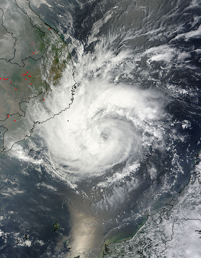
Image credit: The MODIS instrument on NASA's Terra satellite captured a true-color image of Typhoon Pakhar on March 30, 2012 at 03:20 UTC (March 29 at 11:20 p.m. EDT) moving through the South China Sea toward Vietnam. NASA Goddard MODIS Rapid Response Team
Typhoon-force winds, heavy rainfall, and very rough coastal conditions are expected as Pakhar nears the coast of Vietnam later today, Saturday and Sunday (March 31/April 1 UTC). After landfall, Pakhar is forecasted to move inland and dissipate quickly.
According to the Saffir-Simpson damage scale the potential property damage and flooding from a storm of Pakhar’s strength (category 1) at landfall includes:
Storm surge generally 1.2-1.5 metres (4-5 feet) above normal.
No real damage to building structures.
Damage primarily to unanchored mobile homes, shrubbery, and trees.
Some damage to poorly constructed signs.
Some coastal road flooding and minor pier damage.
There is also the potential for flooding further inland due to heavy rain.
The information above is provided for guidance only and should not be used to make life or death decisions or decisions relating to property. Anyone in the region who is concerned for their personal safety or property should contact their official national weather agency or warning centre for advice. (TropicalStorm Risk (TSR))
NASA’s Aqua and TRMM satellites have been providing forecasters with valuable data on Typhoon Pakhar, that includes rainfall rates, cloud extent and temperature.
The Tropical Rainfall Measuring Mission (TRMM) satellite flew almost directly over Pakhar when it was a newly formed tropical storm in the South China Sea on March 29, 2012 at 11:22 UTC/4:22 p.m. Asia local time (or 7:22 a.m. EDT). The intensifying storm had wind speeds of about 45 knots (~52 mph/~83 kph) and was moving toward the west-northwest when viewed by this TRMM pass. A rainfall analysis used data from TRMM’s Microwave Imager and Precipitation Radar (PR) instruments. It showed that moderate to heavy rainfall of about 35 mm/hr (~1.4 inches) was located in an area around Pakhar’s southwestern side.

As Pakhar continues to intensify while moving slowly west towards Vietnam, forecasters at the Joint Typhoon Warning Center expect the storm to peak near 80 knots (90 mph/148 kph) before landfall. Landfall is forecast to occur near Phan Thiet, Vietnam around 1 a.m. Asia/Ho Chi Minh local time on Sunday, April 1 (18:00 UTC / 2 p.m. EDT on Saturday, March 31).
Sources: TropicalStormRisk.com, Nasa.gov
I'm a dedicated researcher, journalist, and editor at The Watchers. With over 20 years of experience in the media industry, I specialize in hard science news, focusing on extreme weather, seismic and volcanic activity, space weather, and astronomy, including near-Earth objects and planetary defense strategies. You can reach me at teo /at/ watchers.news.
Commenting rules and guidelines
We value the thoughts and opinions of our readers and welcome healthy discussions on our website. In order to maintain a respectful and positive community, we ask that all commenters follow these rules.