
Shallow and very dangerous 6.1 magnitude earthquake struck South Australia
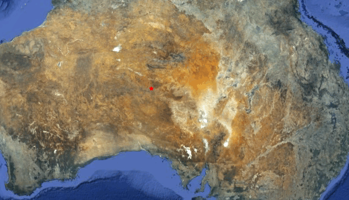
Image credit: Google Earth + USGS
Magnitude 6.1 earthquake struck sparsely populated area of South Australia’s Far North at 09:25:16 UTC on March 23, 2012 according to Geoscience, Australia. USGS reported magnitude 5.6 earthquake. The epicenter was located 317 km (196 miles) SSW of Alice Springs, Northern Terr., Australia (26.068°S, 132.123°E). The depth of epicenter reported by Geoscience was only 3 km! USGS reported depth at 10.7 km (6.6 miles). Australia’s Geoscience is the organization with multiple instruments installed all over Australia and has to be considered as most accurate.
Australian scientists have calculated that it was probably felt in a radius of 507 km around the epicenter. Damage might be inflicted in a radius of 40 km from the epicenter. “There are a number of Aboriginal communities near the epicentre and they would have felt the earthquake strongly,” he said.
This earthquake was the most powerful in Australia since a 6.3 magnitude quake off Collier Bay, on Western Australia’s north coast, on August 10, 1997.
It is the second largest quake to be recorded in South Australia. The biggest was a 6.5 magnitude jolt near Beachport in the South East in 1897, which caused chaos at the nearby town of Kingston and was felt in Adelaide.
Dr Jepsen (Seismologist at Geoscience), said a 4.3 magnitude earthquake struck near the same location about a week ago.

This earthquake has to be called VERY DANGEROUS for the people living in the immediate vicinity of the epicenter.
USGS has calculated that approx. 1,000 people will have experienced a strong shaking (MMI VI) and another 1,000 a moderate MMI V shaking. 3,000 people a light shaking.
We do not expect “experience reports” from this very remote area in Australia’s inland.
All world agencies are reporting almost similar magnitudes (in between 5.4 and 5.7).
I'm a dedicated researcher, journalist, and editor at The Watchers. With over 20 years of experience in the media industry, I specialize in hard science news, focusing on extreme weather, seismic and volcanic activity, space weather, and astronomy, including near-Earth objects and planetary defense strategies. You can reach me at teo /at/ watchers.news.
It reads like a field test of the Tesla Mechanical Oscillator.
And it reminds me of the Aum gang from Japan, testing the Tesla Magnifying Transmitter in the hinterlands of Oz in the late 1980s, per Tom Bearden…
http://www.rexresearch.com/teslamos/tmosc.htm
http://www.rexresearch.com/teslamt/tmagxmtr.htm
Why would we not expect ‘experience reports’ from the beautiful Anangu people of this region? They speak a number of languages including English and Telstra has telephone, mobile and internet coverage into this very community (Pukatja/Ernabella). The ABC has contact with various Aboriginal organisations in this area. Give NPY Women’s Council a bell and ask its Directors and members to facilitate comment/reports.
Have there been any fracking sites in the Amadeus Basin?
A quake of this magnitude and depth in this region could not possibly be due to fracking. However, I am puzzled by the discrepancies between the reporting agencies. Regardless, even USGS’s report of a 5.6 at 3+K depth is a certain anomally in this region. We must consider the recent E-quake activity surrounding this region.