
Tornado warnings may soon arrive far earlier than they do today
Researchers at the University of Kansas report that the National Severe Storms Laboratory’s Warn-on-Forecast System can extend tornado warning lead times beyond the current average of about 15 minutes, according to a study published in Weather and Forecasting.
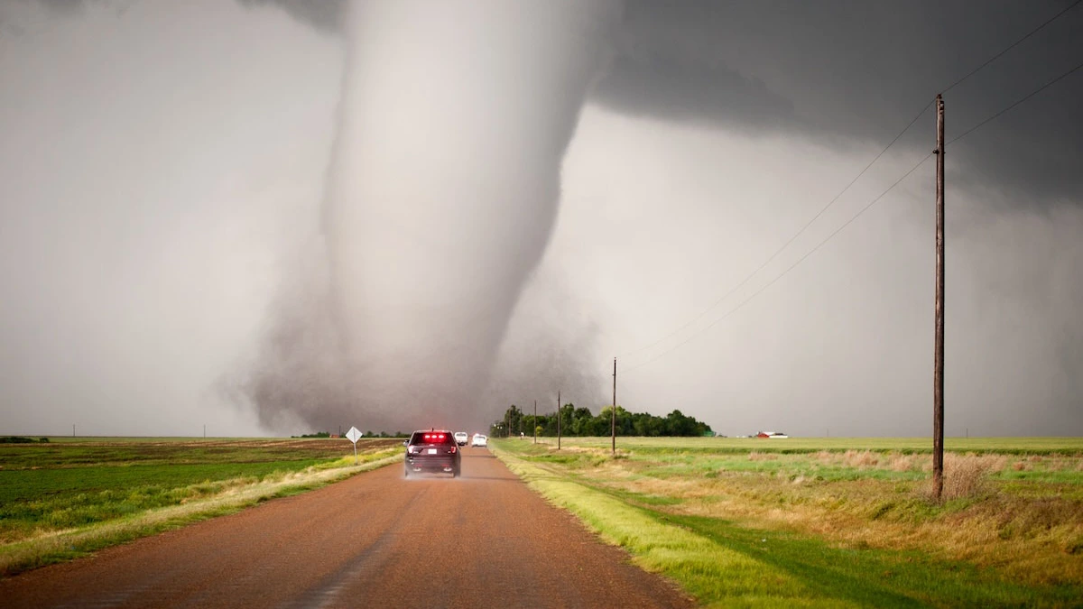
A tornado touches down near Dodge City on May 24, 2016. The current lead time on issuing tornado warnings is about 15 minutes. More lead time from the Warn-on-Forecast system could save lives and property across the Great Plains and beyond, KU researchers found. Credit: Lane Pearman
A tornado moved through farmland near Minden, Iowa, on April 26, 2024. For people living in that part of the Midwest, the sequence was familiar. Skies darkened, phones buzzed, sirens followed, and within minutes, the moment to act arrived. Across much of the United States, tornado warnings still have a narrow lead time, typically about 15 minutes before impact.
Researchers at the University of Kansas say that limited warning time is not only a matter of storm speed or radar coverage but largely a consequence of how warnings are issued. Their new study shows that a different forecasting approach could extend tornado warning lead times to nearly an hour in some cases, radically changing how communities prepare for severe weather.
The research examines the Warn-on-Forecast System (WoFS), developed at the National Severe Storms Laboratory. The findings were published in the peer-reviewed journal Weather and Forecasting.
Tornado forecasting already begins days before storms form. Meteorologists often know three or four days in advance when atmospheric conditions favor severe weather across Kansas, Oklahoma, or neighboring states. As the event approaches, forecasts are refined, and watches are issued to signal heightened risk. The final step, however, still depends on detection.
Under the current warn-on-detection approach, warnings are issued when strong rotation appears on radar or when storm spotters confirm a tornado on the ground. This ensures warnings are accurate, but it also means they arrive when danger is imminent or already unfolding.
WoFS is designed to work earlier in the timeline. Instead of waiting for confirmation, the system focuses on prediction. It continuously ingests real-time observations and runs high-resolution simulations that show how storms are likely to evolve over the next 30–60 minutes. Rather than producing a single outcome, it generates multiple scenarios that describe uncertainty and risk.
The system allows forecasters to see when a storm is trending toward tornado formation before traditional radar thresholds are reached, but human judgment remains significant. WoFS provides guidance, not automated warnings.
To evaluate the effectiveness of their approach, the research team analyzed 41 supercell thunderstorms across the Great Plains, commonly known as Tornado Alley. Each storm either produced a tornado rated EF-1 or stronger on the Fujita scale or significant hail without a tornado. Supercells are capable of both outcomes, making them difficult to distinguish in real time.
The study followed how such storms evolved over roughly one hour, examining changes in low-level wind rotation, radar reflectivity, and the flow of air into the storm. This time-evolving perspective helped researchers identify patterns that appear before tornado formation rather than at the moment it begins.
One of the clearest results was that isolated extreme values were often misleading. Metrics such as the single strongest wind shear or peak instability did not reliably separate tornadic storms from non-tornadic ones. What mattered more was the size and coherence of the environment surrounding the storm.
Storms that produced tornadoes tended to occur within larger, well-defined regions of favorable conditions that developed earlier and persisted longer. Storms that produced large hail alone were more often associated with smaller, fragmented pockets.
Storm-relative helicity was identified as the lead signal. This measure describes corkscrew-like motion in the lower atmosphere relative to a storm’s movement. When rotating air flows into a storm’s updraft, it can be tilted vertically, feeding the rotation that tornadoes draw energy from. Tornado-producing storms were consistently linked to broader and more persistent areas of enhanced storm-relative helicity.
Other factors that increased the likelihood of tornado formation include lower cloud bases, stronger low-level wind shear and small pockets of enhanced rotation near the storm’s inflow region.
Because WoFS resolves these features at very fine spatial scales, it was able to detect signals of tornado development earlier than radar-based detection alone. In several cases examined, guidance pointing to increased tornado potential appeared up to 60 minutes before a tornado formed. Compared with the typical 15-minute warning window, that additional time changes how decisions can be made.
For residents, earlier warnings reduce the need for last-minute decisions and allow more deliberate movement to a safe shelter. For county-level emergency managers, extra lead time allows resources to be positioned, hospitals to coordinate staffing, and search-and-rescue operations to be prepared before damage occurs.
WoFS remains in an experimental phase and is being evaluated in live forecasting environments. Its primary users are forecasters with the National Weather Service, who access the system through cloud-based platforms. As a public service, the National Weather Service makes its products freely available to meteorologists, researchers, and the public.
Tornadoes will always carry uncertainty, and no system can guarantee long warning times for every storm. What this research shows is that many of the signals pointing toward tornado formation are already present well before a funnel reaches the ground. Using those signals earlier could shift warnings from last-minute alerts to earlier calls to action.
For communities across the Great Plains and the Southeast, that shift aligns with the mission of the National Weather Service to protect lives and property. Time remains the most valuable resource when severe weather strikes, and gaining even part of an hour can make a big difference.
References:
1 Tornado-forecast system can increase warning lead times, study finds – KU News – January 27, 2025
2 A Comparative Analysis of Near-Storm Environments for Tornadic and Nontornadic Significant-Hail Supercells Using the Warn-on-Forecast System (WoFS) – Jerod W. Kaufman et al. – Weather and Forecasting – October 28, 2025 – https://doi.org/10.1175/WAF-D-25-0016.1 – OPEN ACCESS

I’m a science journalist and researcher at The Watchers, contributing to the Epicenter edition, where I cover peer-reviewed scientific research and emerging discoveries across Earth and space sciences. With a background in astronomy and a passion for environmental science, I’ve worked in shark and coral conservation in Fiji, conducting reef and shark-behavior research, contributing to mangrove restoration, and earning PADI Open Water and Coral Reef Certifications. I bring a blend of scientific rigor and storytelling to illuminate the discoveries shaping our planet and beyond.
Commenting rules and guidelines
We value the thoughts and opinions of our readers and welcome healthy discussions on our website. In order to maintain a respectful and positive community, we ask that all commenters follow these rules.