
New study redefines how continents split and why some never do
Tulane University and an international research team have discovered that parts of East Africa’s crust are too strong to split, revealing that ancient volcanic dehydration hardened the region’s lithosphere.

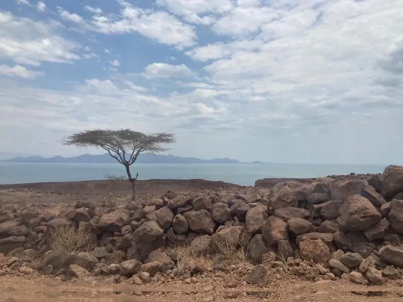
Lake Turkana, seen in the background in Kenya’s Rift Valley, sits within one of the most tectonically active regions on Earth. Tulane researchers studying the area discovered that parts of the crust here are stronger and more resistant to breaking apart than previously thought. Credit: Cynthia Ebinger
Tulane University researchers, working with an international team of scientists, have discovered why some parts of the Earth’s crust remain strong while others give way—overturning long-held assumptions about how continents split apart.
Published in Nature on November 5, 2025, the study examines a section of the East African Rift, one of the few places on Earth where the process of continental breakup can still be observed today. Tulane researchers focused on the Turkana Depression between Kenya and Ethiopia to understand why certain regions resist deformation or fail to break up at all.
Working with colleagues from the University of Montana, Imperial College London, Addis Ababa University in Ethiopia, and the University of Nairobi and Dedan Kimathi University in Kenya, the team found that an area of the African tectonic plate that had once been stretched and thinned was now resisting deformation—the opposite of what scientists expected.
“Our modeling systematically eliminated the possible factors controlling where plate rifting initiates,” said Cynthia Ebinger, Tulane professor in the Department of Earth and Environmental Sciences in the School of Science and Engineering.
The results show that a heating event about 80 million years ago dehydrated the plate, removing water and carbon dioxide from deep layers and leaving behind a stronger, more rigid crust.
“The team brought a wide range of skills and data sets to visualize the plate structure and its properties, and our modeling systematically eliminated the possible factors controlling where plate rifting initiates,” Ebinger added.
Mapping a hidden strength
Tulane scientists led the earthquake and GPS monitoring that revealed these hidden processes. By using networks of instruments to measure both steady plate motion and rapid shifts caused by earthquakes, the team created three-dimensional maps showing how deformation and volcanism divert around the previously thinned zones, leaving those thinner regions barely deforming at all.
“Our collaborative research shows that volcanism and plate stretching that form deep basins avoid the thin and dry parts of the continental plates,” said Martin Musila, whose PhD research at Tulane explored the tectonic conundrum that the paper resolves. “In this area, water and CO2 in the deep layers of the plate were extracted by volcanism 80 million years ago, and dehydration makes the plate stronger and seismic velocities faster.”
These findings indicate that volcanic and tectonic processes bypass parts of the crust that lost volatiles during earlier geological episodes. Rather than being weak points for future rifting, those dehydrated sections now act as barriers to deformation, reshaping how scientists understand the evolution of continental plates.
Ancient rifts that strengthened the Earth
The discovery helps explain how failed rifts, ancient attempts by continents to split, can actually make tectonic plates stronger and more resistant to future breakup. When a rifting episode fails and the area cools, dehydration from earlier volcanism leaves behind a dry, chemically stable lithosphere that resists later deformation.
The East African Rift is one of the few active examples on Earth where this can be observed in real time. The Turkana Depression, once part of the failed Anza Rift during the Late Cretaceous (about 100–66 million years ago), provides an exceptional natural laboratory for studying how crustal strength evolves through time.
By combining seismic data, GPS measurements, and plate motion models, the Tulane-led team demonstrated that deformation in the region now circumvents the older, thinned crust instead of exploiting it. This discovery overturns the long-held assumption that once-thinned lithosphere remains weak and prone to reactivation.
Global and practical implications
The research not only deepens understanding of how continents evolve but also improves models used to forecast earthquake and volcanic hazards. In East Africa, where population centers lie along tectonic boundaries, identifying stable and deforming zones can help assess where future seismic activity is most likely to occur.
Beyond hazard science, the results also inform the search for mineral and energy resources. Many of the world’s oil- and gas-bearing basins formed in ancient rifts that later stabilized. By showing that failed rifts can strengthen rather than weaken the crust, the study refines models for locating subsurface resources in similar geological settings, including ancient rift systems like those beneath the U.S. Gulf Coast.
The findings underscore that the Earth’s lithosphere carries a “memory” of its past. Ancient events, such as the volcanism that dehydrated the African plate tens of millions of years ago, continue to shape how modern rifting unfolds.
References:
1 Tulane researchers uncover why breaking up is hard for some continents – Tulane University – November 5, 2025
2 The importance of past rifting in large igneous province development – Kounoudis, R., Bastow, I.D., Ebinger, C.J. et al. – Nature – November 5, 2025 – https://doi.org/10.1038/s41586-025-09668-7 – OPEN ACCESS

I’m a science journalist and researcher at The Watchers, contributing to the Epicenter edition, where I cover peer-reviewed scientific research and emerging discoveries across Earth and space sciences. With a background in astronomy and a passion for environmental science, I’ve worked in shark and coral conservation in Fiji, conducting reef and shark-behavior research, contributing to mangrove restoration, and earning PADI Open Water and Coral Reef Certifications. I bring a blend of scientific rigor and storytelling to illuminate the discoveries shaping our planet and beyond.
Indeed.
I read through the paper, resisting the urge to request summaries.
Any fellow Watcher appreciating the stasis and contiguous nature of the underlying LLVP structure implied, including its relative shallowness and position with respect to the surface? Or at least this part of the LLVP; partiality maybe moot because flow dynamics, like wind up the side of an 8000m peak, not the same but analogous.
My understanding is data suggests there is no such shallow LLVP under the US Gulf, or anywhere else on Earth, just one counterpart, in the Pacific and deep, so a unique geomorphology in Ethiopia, yes this does speak to deep alkane and silane production, with other commodities but there may be more profound implications to:
Any one else suspecting behaviour in this location is one of our most accessible direct barometers globally on core-magma-asthenosphere kinetics? With its link to geomagnetics, and beyond. Cycles. Dhzanbenikov; asymmetric LLVPs.
Interesting that Lake Turkana is, as near as makes little difference, on the equator; Earth oblate-spheroid considerations inclusive.
Also interesting, Leakey etc. Omo I, II, ca. 230kyrs BP found in this region i.e. no massive energetic flooding or substantive substrate solubilising. Contrast Saharan dynamics. But, volcanic ash. Stunning Omo river and valley.