
Extreme subsidence in Mexico City exceeds 2 cm (0.8 inches) per month
Preliminary measurements from the NASA-ISRO Synthetic Aperture Radar (NISAR) satellite mapped parts of Mexico City and surrounding areas subsiding by more than 2 cm (0.8 inches) per month between October 25, 2025, and January 17, 2026, NASA’s Jet Propulsion Laboratory (JPL) reported. JPL attributed the deformation in large part to groundwater pumping and long-term compaction of the ancient lakebed beneath the metropolitan area.
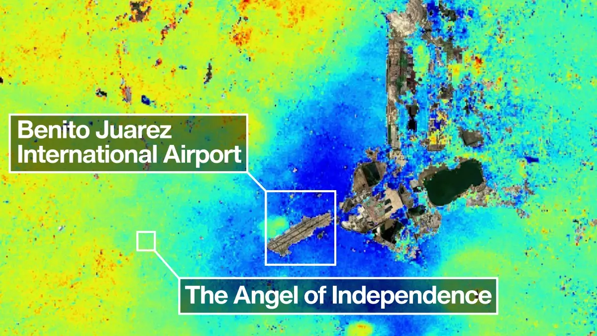
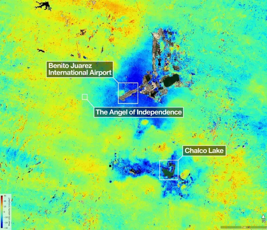
New data from NISAR shows where Mexico City and its environs subsided by up to a few centimeters per month (shown in blue) between Oct. 25, 2025, and Jan. 17, 2026. Uneven and seemingly small elevation changes have added up over the decades, fracturing roads, buildings, and water lines. Credit: NASA/JPL-Caltech/David Bekaert
NISAR mapped ground movement beneath Mexico City with L-band synthetic aperture radar, a long-wavelength instrument designed to measure small changes in land and ice surfaces from orbit.
The satellite can operate day and night and through cloud cover, allowing repeated measurement of land sinking, land uplift, glacier motion, and crop growth during multiple overpasses each month.
The analysis was based on preliminary measurements collected during Mexico City’s dry season. JPL said dark blue areas in the image provided mark zones subsiding by more than 2 cm (0.8 inches) per month, while yellow and red areas are likely residual noise signals and are expected to decrease as NISAR collects additional data.
Mexico City and its surrounding urban area are home to about 20 million people and sit above an aquifer in the basin of an ancient lake. JPL attributed more than a century of compaction to extensive groundwater pumping combined with the weight of urban development, with the issue first documented by an engineer in 1925. Uneven elevation loss has accumulated over decades, fracturing roads, buildings, and water lines.
By the 1990s and 2000s, parts of the metropolitan area were sinking by around 35 cm (14 inches) per year, further damaging infrastructure, including the Metro system. Peer-reviewed research has identified Metro-related vulnerabilities linked to subsidence deformation, including braking-safety design constraints, railway flooding hazard, railway bending, and reduced service life for elevated overpasses.
The NISAR image places Benito Juárez International Airport near the center of the mapped deformation field, with Lake Nabor Carrillo visible northeast of the airport.
Angel of Independence along Paseo de la Reforma, in particular, is a visible marker of long-term subsidence. This 35 m (114 feet) monument, built in 1910, has had 14 steps added to its base as the surrounding land gradually sank.
The satellite is a joint mission developed by the National Aeronautics and Space Administration (NASA) and the Indian Space Research Organisation (ISRO). JPL provided the L-band synthetic aperture radar and antenna reflector, while ISRO provided the spacecraft bus and S-band synthetic aperture radar; the mission launched from Satish Dhawan Space Centre on India’s southeastern coast in July 2025.
Peer-reviewed research supports the groundwater-pumping mechanism identified by JPL. Zapata-Norberto et al. (2025) reported total settlement of 3.661 m (12 feet) over 10 years at a Mexico City monitoring site, with an average rate of 0.314 m/year (1 foot/year), and found that most consolidation-related deformation was registered below 82 m (269 feet), within the regional aquifer system.
Solano-Rojas et al. (2024) reported that Mexico City subsidence rates reach 500 mm/year (20 inches/year) and that high subsidence-velocity gradients occur along transitions between stable and fast-subsiding zones, producing slope changes up to 3.5% over 20 years and differential displacements between columns.
References:
1 US-Indian Space Mission Maps Extreme Subsidence in Mexico City – NASA/JPL – April 29, 2026
I'm a dedicated researcher, journalist, and editor at The Watchers. With over 20 years of experience in the media industry, I specialize in hard science news, focusing on extreme weather, seismic and volcanic activity, space weather, and astronomy, including near-Earth objects and planetary defense strategies. You can reach me at teo /at/ watchers.news.
Commenting rules and guidelines
We value the thoughts and opinions of our readers and welcome healthy discussions on our website. In order to maintain a respectful and positive community, we ask that all commenters follow these rules.